
The Borough of Broxbourne is a local government district and borough in Hertfordshire, England. Its council is based in Cheshunt. Other towns include Broxbourne, Hoddesdon and Waltham Cross. The eastern boundary of the district is the River Lea. The borough covers 20 square miles (52 km2) in south east Hertfordshire having a population of about 96,000.

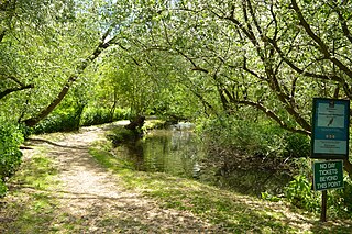
Cheshunt is a town in Hertfordshire, England, 13 miles (21 km) north of London on the River Lea and Lee Navigation and 11 miles north of Liverpool street. It contains a section of the Lee Valley Park, including much of the River Lee Country Park. To the north lies Broxbourne and Wormley, Waltham Abbey to the east, Waltham Cross and Enfield to the south, and Cuffley to the west.
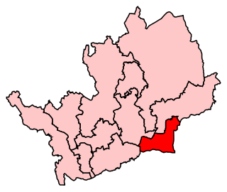
Broxbourne is a constituency in Hertfordshire represented in the House of Commons of the UK Parliament since 2005 by Charles Walker of the Conservative Party.
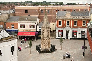
Waltham Cross is a town in the Borough of Broxbourne, Hertfordshire, England, located 12 miles (19 km) north of central London. In the south-eastern corner of Hertfordshire, it borders Cheshunt to the north, Waltham Abbey to the east, and Enfield to the south, forming part of the metropolitan area of London and the Greater London Urban Area.

Broxbourne is a town and former civil parish, now in the unparished area of Hoddesdon, in the Borough of Broxbourne district, in Hertfordshire, England, with a population of 15,303 at the 2011 Census. It is located to the south of Hoddesdon and to the north of Cheshunt, 17.1 miles (27.5 km) north of London. The town is near the River Lea, which forms the boundary with Essex, and 4.5 miles (7.2 km) north of the M25 motorway. To the west of the town are Broxbourne Woods, a national nature reserve. The Prime Meridian runs just east of Broxbourne.

Football Club Broxbourne Borough is a football club based in Broxbourne, Hertfordshire, England. They play at Goffs Lane in Cheshunt.

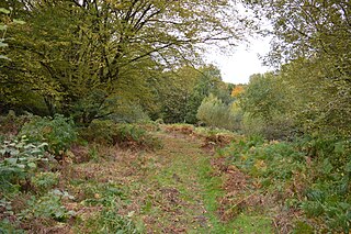
Wormley-Hoddesdonpark Wood South is a 192.5 hectare is a biological site of Special Scientific Interest near Cheshunt in Hertfordshire. It is part of Broxbourne Woods National Nature Reserve, and is listed in A Nature Conservation Review. Wormley Wood is owned and managed by the Woodland Trust. The site is also a Special Area of Conservation.

Wormley-Hoddesdonpark Wood North is a 143.9-hectare (356-acre) woodland area in Hertfordshire which has been designated as a biological site of Special Scientific Interest. The site is listed as Grade 1 in A Nature Conservation Review, and is also designated a Special Area of Conservation. It is in Hoddesdon in the borough of Broxbourne, but part of the site is in East Hertfordshire.

Wormley is a village and former civil parish, now in the unparished area of Hoddesdon, in the Broxbourne district, in the county of Hertfordshire, England. The village is part of the census ward of Wormley and Turnford, which had a population of 8,146 at the 2001 census. In 1931 the parish had a population of 930.

Turnford is a village in the Borough of Broxbourne, in Hertfordshire, England, in an area generally known as the Lee Valley. It is bounded by Wormley to the north, Cheshunt to the south and west, and its eastern boundary is formed largely by the Lee Navigation. Central London at Charing Cross is approximately 18 miles (29 km) south. At the 2001 census, together with Wormley, the village had a population of 8,146 in 3,399 households.

Northaw Great Wood is a 223.6-hectare (553-acre) biological Site of Special Scientific Interest (SSSI) near Cuffley in Hertfordshire, England. It covers Northaw Great Wood Country Park, which is managed by Welwyn Hatfield Borough Council, Well Wood, Justice Hill and Grimes Bottom. Part of the site is managed by Hertfordshire County Council as a schools' park. The country park is also a local nature reserve.

Mardley Heath is a 41.1 hectare Local Nature Reserve in Welwyn in Hertfordshire. It is owned by Welwyn Hatfield Borough Council and managed by the council together with the Friends of Mardley Heath.
Stanborough Reedmarsh is a 3.3 hectare Local Nature Reserve in Welwyn Garden City in Hertfordshire. It is owned by Welwyn Hatfield Borough Council and managed by the Herts and Middlesex Wildlife Trust.

Top Field and Cozens Grove is a 6.1 hectare Local Nature Reserve in Wormley in Hertfordshire. It is owned and managed by Broxbourne Borough Council.

Danesbury Park is a 24.5-hectare (61-acre) public park and Local Nature Reserve in Welwyn in Hertfordshire. It is owned and managed by Welwyn Hatfield Borough Council.

Garston Park is a park in Garston, Hertfordshire, a suburb of Watford in Hertfordshire. An area of 6.4 hectares, about half of the park, is a Local Nature Reserve. It is owned and managed by Watford Borough Council.

Harebreaks Wood is 5.1 hectare Local Nature Reserve in Watford in Hertfordshire. It is owned by Watford Borough Council and managed by the council and the Friends of Harebreaks Wood.
Danemead is a 5.6-hectare nature reserve west of Hoddesdon in Hertfordshire, managed by the Herts and Middlesex Wildlife Trust. It is part of the Wormley-Hoddesdonpark Wood North Site of Special Scientific Interest.
