Chester, Georgia

Last updated

Chester, Georgia
Dodge County Georgia Incorporated and Unincorporated areas Chester Highlighted.svg
Location in Dodge County and the state of Georgia
Coordinates: 32°23′42″N83°9′13″W / 32.39500°N 83.15361°W / 32.39500; -83.15361
Country United States
State Georgia
County Dodge
Incorporated (town)1912
Area
[1]
  Total0.88 sq mi (2.29 km2)
  Land0.88 sq mi (2.28 km2)
  Water0.00 sq mi (0.01 km2)
Elevation
367 ft (112 m)
Population
 (2020)
  Total525
  Density595.91/sq mi (230.21/km2)
Time zone UTC-5 (Eastern (EST))
  Summer (DST) UTC-4 (EDT)
ZIP code
31012
Area code 478
FIPS code 13-15900 [2]
GNIS feature ID0331384 [3]

Chester is a town in Dodge County, Georgia, United States. The population was 1,596 at the 2010 census, [4] up from 305 in 2000, due to inclusion of Dodge State Prison within the town limits. By 2020, its township population was 525.

Contents

History

The town takes its name from Chester, New York. [5] The Georgia General Assembly incorporated the place in 1902 as the "Town of Chester", with municipal corporate limits extending in a one-mile radius from the Wrightsville and Tennille Railroad depot. [6]

Geography

Chester is located in northern Dodge County at 32°23′42″N83°9′13″W / 32.39500°N 83.15361°W / 32.39500; -83.15361 (32.394965, -83.153610). [7] Georgia State Route 126 passes through the town as Main Street, leading west 13 miles (21 km) to Cochran and southeast 8 miles (13 km) to Cadwell. Georgia State Route 257 joins SR 126 on Main Street through the center of Chester, but leads northeast 7 miles (11 km) to Dexter and southwest 9 miles (14 km) to Empire. Eastman, the Dodge County seat, is 15 miles (24 km) to the south via Chester Highway.

According to the United States Census Bureau, Chester has a total area of 0.89 square miles (2.3 km2), all land. [4]

Demographics

Historical population
CensusPop.Note
1910 278
1920 39742.8%
1930 267−32.7%
1940 2815.2%
1950 31512.1%
1960 37719.7%
1970 4098.5%
1980 4090.0%
1990 1,072162.1%
2000 305−71.5%
2010 1,596423.3%
2020 525−67.1%
U.S. Decennial Census [8]
Chester racial composition as of 2020 [9]
RaceNum.Perc.
White (non-Hispanic)19036.19%
Black or African American (non-Hispanic)31860.57%
Asian 20.38%
Other/Mixed 50.95%
Hispanic or Latino 101.9%

As of the 2020 United States census, there were 525 people, 194 households, and 127 families residing in the town.

Related Research Articles

<span class="mw-page-title-main">Pulaski County, Georgia</span> County in Georgia, United States

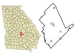
Pulaski County is a county located in the central portion of the U.S. state of Georgia. As of the 2020 census, the population was 9,855. The county seat is Hawkinsville.

<span class="mw-page-title-main">Dodge County, Georgia</span> County in Georgia, United States

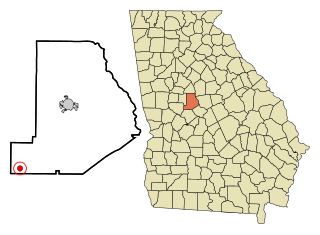
Dodge County is a county located in the central portion of the U.S. state of Georgia. As of 2020, the population was 19,925. The county seat is Eastman. Dodge County lies in the Historic South and Black Belt region of Georgia, an area that was devoted to cotton production in the antebellum years. It has significant historic buildings and plantations, has a substantial African-American population, and shows cultural aspects of the South.

<span class="mw-page-title-main">Chauncey, Georgia</span> City in Georgia, United States

Chauncey is a city in Dodge County, Georgia, United States. The population was 289 at the 2020 census. It was formed around station number twelve on the Macon and Brunswick Railroad.

<span class="mw-page-title-main">Eastman, Georgia</span> City in Georgia, United States

Eastman is a city in Dodge County, Georgia, United States. The population was 5,658 at the 2020 census, up from 4,962 at the 2010 census. The city was named after William Pitt Eastman, a native of Massachusetts who purchased a large tract of land along the Macon and Brunswick Railroad, and settled a city on the site.

<span class="mw-page-title-main">Milan, Georgia</span> City in Georgia, United States

Milan is a city in Dodge and Telfair counties in the U.S. state of Georgia. The population was 700 at the 2010 census, down from 1,012 in 2000. By 2020, its population was 613.

<span class="mw-page-title-main">Rhine, Georgia</span> Town in Georgia, United States

Rhine is a town in Dodge County, Georgia, United States. The population was 295 in 2020.

<span class="mw-page-title-main">Byromville, Georgia</span> Town in Georgia, United States

Byromville is a town in Dooly County, Georgia, United States. The population was 546 at the 2010 census, up from 415 in 2000. In 2020, its population was 422.

<span class="mw-page-title-main">Dooling, Georgia</span> Town in Georgia, United States

Dooling is a town in Dooly County, Georgia, United States. The population was 68 at the 2020 census.

<span class="mw-page-title-main">Pinehurst, Georgia</span> City in Georgia, United States

Pinehurst is a city in Dooly County, Georgia, United States. The population was 309 in 2020.

<span class="mw-page-title-main">Unadilla, Georgia</span> City in Georgia, United States

Unadilla is a city in Dooly County, Georgia, United States. The population was 3,118 in 2020. Dooly State Prison is located in the northeast corner of the city.

<span class="mw-page-title-main">Summertown, Georgia</span> City in Georgia, United States

Summertown is a city in Emanuel County, Georgia, United States. The population was 121 in 2020.

<span class="mw-page-title-main">White Plains, Georgia</span> City in Georgia, United States

White Plains is a city in Greene County, Georgia, United States. The population was 284 at the 2010 census.

<span class="mw-page-title-main">Waverly Hall, Georgia</span> Town in Georgia, United States

Waverly Hall is a town in Harris County, Georgia, United States. It is part of the Columbus, Georgia-Alabama metropolitan statistical area. The population was 638 in 2020.

<span class="mw-page-title-main">Kite, Georgia</span> City in Georgia, United States

Kite is a city in Johnson County, Georgia, United States, along the Little Ohoopee River. The population was 160 in 2020.

<span class="mw-page-title-main">Wrightsville, Georgia</span> City in Georgia, United States

Wrightsville is a city in and the county seat of Johnson County, Georgia, United States. The population was 2,195 at the 2010 census, down from 2,223 at the 2000 census. By 2020, its population grew to 3,449. The city limits include Johnson State Prison on the northeast side of town. Wrightsville is part of the Dublin Micropolitan Statistical Area.

<span class="mw-page-title-main">Cadwell, Georgia</span> Town in Georgia, United States

Cadwell is a town in Laurens County, Georgia, United States. The population was 381 in 2020.

<span class="mw-page-title-main">Dexter, Georgia</span> Town in Georgia, United States

Dexter is a town in Laurens County, Georgia, United States. As of 2020, its population was 655.

<span class="mw-page-title-main">Meigs, Georgia</span> City in Georgia, United States

Meigs is a city in Thomas County, Georgia, United States, with a small portion extending north into Mitchell County. The population was 928 at the 2020 census, down from 1,035 in 2010.

<span class="mw-page-title-main">Tarrytown, Georgia</span> Town in Georgia, United States

Tarrytown is a town in Montgomery County, Georgia, United States. The population was 66 at the 2020 census, down from 87 in 2010.

<span class="mw-page-title-main">Danville, Georgia</span> Town in Georgia, United States

Danville is a town in Twiggs and Wilkinson counties in the U.S. state of Georgia. The population was 238 at the 2010 census, down from 373 in 2000.

References

  1. "2020 U.S. Gazetteer Files". United States Census Bureau. Retrieved December 18, 2021.
  2. "U.S. Census website". United States Census Bureau . Retrieved January 31, 2008.
  3. "US Board on Geographic Names". United States Geological Survey. October 25, 2007. Retrieved January 31, 2008.
  4. 1 2 "Geographic Identifiers: 2010 Demographic Profile Data (G001): Chester town, Georgia". U.S. Census Bureau, American Factfinder. Retrieved October 22, 2015.[ dead link ]
  5. Krakow, Kenneth K. (1975). Georgia Place-Names: Their History and Origins (PDF). Macon, GA: Winship Press. p. 42. ISBN   0-915430-00-2.
  6. Acts Passed by the General Assembly of Georgia. J. Johnston. 1903. p. 363.
  7. "US Gazetteer files: 2010, 2000, and 1990". United States Census Bureau. February 12, 2011. Retrieved April 23, 2011.
  8. "Census of Population and Housing". Census.gov. Retrieved June 4, 2015.
  9. "Explore Census Data". data.census.gov. Retrieved December 18, 2021.