Chestnut Hill, Tennessee

Last updated
Chestnut Hill
Bush's Plant in Tennessee.jpg
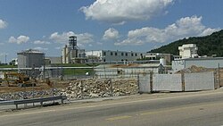
Bush Brothers cannery facility in Chestnut Hill
USA Tennessee location map.svg
Red pog.svg
Chestnut Hill
Usa edcp location map.svg
Red pog.svg
Chestnut Hill
Coordinates: 35°58′8″N83°18′54″W / 35.96889°N 83.31500°W / 35.96889; -83.31500
Country United States
State Tennessee
County Jefferson
Elevation
[1]
1,079 ft (329 m)
Time zone UTC-5 (Eastern (EST))
  Summer (DST) UTC-4 (EDT)
ZIP code
37725
Area code 865
GNIS feature ID1305891 [1]

Chestnut Hill is an unincorporated community located in central-southern Jefferson County, Tennessee. [1]

Contents

Economy

Chestnut Hill is the site of one of two canneries for the Bush Brothers and Company, which has a visitors' center in the community. [2]

Related Research Articles

<span class="mw-page-title-main">Jefferson County, Tennessee</span> County in Tennessee, United States

Jefferson County is an exurban county located in the U.S. state of Tennessee. As of the 2020 census, the population was 54,683. Its county seat is Dandridge. Jefferson County is part of the Morristown Metropolitan Statistical Area with neighboring Grainger and Hamblen counties. The county, along with the Morristown MSA, is included in the Knoxville-Morristown-Sevierville Combined Statistical Area.

<span class="mw-page-title-main">Grainger County, Tennessee</span> County in Tennessee, United States

Grainger County is a county located in the U.S. state of Tennessee. As of the 2020 census, the population was 23,527. Its county seat is Rutledge. Grainger County is a part of both the Knoxville Metropolitan Statistical Area and Morristown Metropolitan Statistical Area.

<span class="mw-page-title-main">Ashe County, North Carolina</span> County in North Carolina, United States

Ashe County is a county located in the U.S. state of North Carolina. As of the 2020 census, the population was 26,577. Its county seat is Jefferson.

<span class="mw-page-title-main">Jefferson Hills, Pennsylvania</span> Borough in Pennsylvania, United States

Jefferson Hills is a borough that is located in Allegheny County, Pennsylvania, United States. Part of the West Jefferson Hills School District, Jefferson Hills was created as Jefferson Township. Incorporated on January 22, 1828, it was named after Thomas Jefferson. Before 1998, the borough was known as Jefferson.

<span class="mw-page-title-main">Morristown, Tennessee</span> Largest city and county seat of Hamblen County, Tennessee, United States

Morristown is a city in and the county seat of Hamblen County, Tennessee. Morristown also extends into Jefferson County on the western and southern ends. The city's population was recorded to be 30,431 at the 2020 United States census. It is the principal city of the Morristown Metropolitan Statistical Area, which encompasses all of Grainger, Hamblen, and Jefferson counties. The Morristown metropolitan area is also part of the Knoxville-Morristown-Sevierville Combined Statistical Area.

Chestnut Hill may refer to:

<span class="mw-page-title-main">Chestnut Hill, Philadelphia</span> Neighborhood of Philadelphia in Pennsylvania, United States

Chestnut Hill is a neighborhood in the Northwest Philadelphia section of Philadelphia, Pennsylvania, United States. It is known for the high incomes of its residents and high real estate values, as well as its private schools.

Oak Grove may refer to:

<span class="mw-page-title-main">Southwest Mountains</span> Mountain range in Virginia, U.S.

The Southwest Mountains of Virginia are a mountain range centered on Charlottesville, parallel to and geologically associated with the Blue Ridge Mountains, which lie about 30 miles (50 km) to the west. Some of the more prominent peaks include Carters Mountain, Fan Mountain, Brush Mountain, Peters Mountain, Walton's Mountain, and Hightop Mountain.

<span class="mw-page-title-main">U.S. Route 411</span> Numbered U.S. Highway in Alabama, Georgia, and Tennessee in the United States

U.S. Route 411 (US 411) is an alternate parallel-highway associated with US 11. It extends for about 309.7 miles (498.4 km) from US 78 in Leeds, Alabama, to US 25W/US 70 in Newport, Tennessee. US 411 travels through northeastern Alabama, northwestern Georgia, and southeastern Tennessee. It is signed north-south, as with most highways that have odd numbers, but the route runs primarily in a northeast-southwest direction, and covers a more east-west mileage than it does north-south. Notable towns and cities along its route include Gadsden, Alabama; Rome, Georgia; Cartersville, Georgia; Maryville, Tennessee; Sevierville, Tennessee, and Newport, Tennessee.

<span class="mw-page-title-main">Chestnut Hill, Massachusetts</span> Village in Massachusetts, United States

Chestnut Hill is a wealthy New England village located six miles (10 km) west of downtown Boston, Massachusetts, United States. Like all Massachusetts villages, Chestnut Hill is not an incorporated municipal entity. It is located partially in Brookline in Norfolk County; partially in the city of Boston in Suffolk County, and partially in the city of Newton in Middlesex County. Chestnut Hill's borders are defined by the 02467 ZIP Code. The name refers to several small hills that overlook the 135-acre Chestnut Hill Reservoir rather than one particular hill. Chestnut Hill is best known as the home of Boston College and as part of the Boston Marathon route.

<span class="mw-page-title-main">Strawberry Plains, Tennessee</span> CDP in Tennessee, United States

Strawberry Plains is an unincorporated community and census-designated place (CDP) in Jefferson, Knox, and Sevier counties in the State of Tennessee, United States. Before 2010, it was treated by the United States Census Bureau as a census county division. It is included in both the Knoxville Metropolitan Statistical Area and the Morristown Metropolitan Statistical Area.

<span class="mw-page-title-main">Morristown metropolitan area</span> Metropolitan area based in Morristown, Tennessee, United States

The Morristown Metropolitan Statistical Area, commonly known as the Lakeway Area, as defined by the United States Census Bureau, is an area consisting of three counties - Grainger, Hamblen, and Jefferson - in eastern Tennessee, anchored by the city of Morristown. As of the 2000 census, the MSA had a population of 123,081. A July 1, 2009 estimate placed the population at 137,612).

<span class="mw-page-title-main">Heiskell, Tennessee</span> Unincorporated community in Tennessee, United States

Heiskell is an unincorporated community in Knox and Anderson counties, Tennessee, United States. It is the location of a post office, assigned ZIP code 37754.

<span class="mw-page-title-main">Tennessee State Route 92</span>

State Route 92 is a state highway in East Tennessee with both four lane and two lane sections.

<span class="mw-page-title-main">Tennessee State Route 363</span>

State Route 363, also known as Indian Creek Road, is a 6.0-mile-long (9.7 km) east-west mile long state highway in Jefferson County, Tennessee. It provides access to lakeside homes and marinas along the south shore of Douglas Lake.

<span class="mw-page-title-main">Tennessee's 8th Senate district</span> American legislative district

Tennessee's 8th Senate district is one of 33 districts in the Tennessee Senate. It has been represented by Republican Frank Niceley since 2012. It is currently the most Republican-leaning Senate district in the state.

References

  1. 1 2 3 U.S. Geological Survey Geographic Names Information System: Chestnut Hill, Tennessee
  2. "Industry". Select Jefferson County. Retrieved November 3, 2020.