
Sevier County is a county of the U.S. state of Tennessee. As of the 2020 census, the population was 98,380. Its county seat and largest city is Sevierville. Sevier County comprises the Sevierville, TN Micropolitan Statistical Area, which is included in the Knoxville-Morristown-Sevierville, TN Combined Statistical Area.

Jefferson County is an exurban county located in the U.S. state of Tennessee. As of the 2020 census, the population was 54,683. Its county seat is Dandridge. Jefferson County is part of the Morristown Metropolitan Statistical Area with neighboring Grainger and Hamblen counties. The county, along with the Morristown MSA, is included in the Knoxville-Morristown-Sevierville Combined Statistical Area.

Grainger County is a county located in the U.S. state of Tennessee. As of the 2020 census, the population was 23,527. Its county seat is Rutledge. Grainger County is a part of both the Knoxville Metropolitan Statistical Area and Morristown Metropolitan Statistical Area.
Cocke County is a county on the eastern border of the U.S. state of Tennessee. As of the 2020 census, the population was 35,999. Its county seat is Newport. Cocke County comprises the Newport, TN Micropolitan Statistical Area, which is part of the Knoxville-Morristown-Sevierville, Tennessee Combined Statistical Area.

Bradley County is a county located in the southeastern portion of the U.S. state of Tennessee. As of the 2020 census, the population was 108,620, making it the thirteenth most populous county in Tennessee. Its county seat is Cleveland. It is named for Colonel Edward Bradley of Shelby County, Tennessee, who was colonel of Hale's Regiment in the American Revolution and the 15th Regiment of the Tennessee Volunteers in the War of 1812. Bradley County is included in the Cleveland, Tennessee Metropolitan Statistical Area, which is also included in the Chattanooga-Cleveland-Dalton, TN-GA-AL Combined Statistical Area.

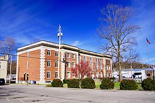
Dandridge is a town in and the county seat of Jefferson County, Tennessee. It had a population of 3,344 at the 2020 census. The town is part of the Morristown, Tennessee Metropolitan Statistical Area, which consists of Jefferson, Hamblen, and Grainger counties.

Morristown is a city in and the county seat of Hamblen County, Tennessee, United States. Morristown also extends into Jefferson County on the western and southern ends. The city lies within the Ridge and Valley of the Appalachians. The city's population was recorded to be 30,431 at the 2020 United States census. It is the principal city of the Morristown Metropolitan Statistical Area, which encompasses all of Grainger, Hamblen, and Jefferson counties. The Morristown metropolitan area is also part of the Knoxville-Morristown-Sevierville Combined Statistical Area.

White Pine is a town in Jefferson and Hamblen counties in Tennessee, United States. It is part of the Morristown metropolitan area. The population was 2,471 at the 2020 census.

U.S. Route 11E (US 11E) is a divided highway of US 11 in the U.S. states of Tennessee and Virginia. The United States Numbered Highway, which is complemented by US 11W to the north and west, runs 120.94 miles (194.63 km) from US 11, US 11W, and US 70 in Knoxville, Tennessee, north and east to US 11, US 11W, US 19, and US 421 in Bristol, Virginia. US 11E connects Knoxville and the twin cities of Bristol, Virginia, and Bristol, Tennessee, with the East Tennessee communities of Morristown, Greeneville, and Johnson City. The U.S. Highway runs concurrently with US 70 and US 25W east of Knoxville, US 321 from Greeneville and Johnson City, and both US 19W and US 19 between Johnson City and Bristol. US 11E also has an unsigned concurrency with State Route 34 (SR 34) for almost all of its course in Tennessee.

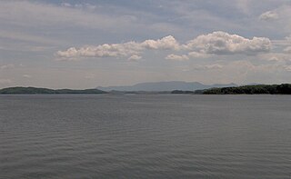
Douglas Dam is a hydroelectric dam on the French Broad River in Sevier County, Tennessee, in the southeastern United States. The dam is operated by the Tennessee Valley Authority (TVA), which built the dam in record time in the early 1940s to meet emergency energy demands at the height of World War II. Douglas Dam is a straight reinforced concrete gravity-type dam 1705 feet long and 202 feet high, impounding the 28,420-acre (11,500 ha) Douglas Lake. The dam was named for Douglas Bluff, a cliff overlooking the dam site prior to construction.
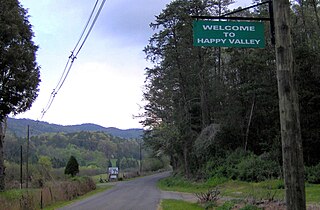
Happy Valley is an unincorporated community in Blount County, Tennessee, near the Great Smoky Mountains National Park. Although it is not a census-designated place, the ZIP Code Tabulation Area for the ZIP Code (37878) that serves Happy Valley had a population of 529 as of the 2000 U.S. Census.

Del Rio is an unincorporated community in Cocke County, Tennessee, United States. Although it is not a census-designated place, the ZIP Code Tabulation Area for the ZIP Code (37727) that serves Del Rio had a population of 2,138, according to the 2000 census.

Strawberry Plains is an unincorporated community and census-designated place (CDP) in Jefferson, Knox, and Sevier counties in the State of Tennessee, United States. Before 2010, it was treated by the United States Census Bureau as a census county division. It is included in both the Knoxville Metropolitan Statistical Area and the Morristown Metropolitan Statistical Area.

Walland is an unincorporated community and census-designated place (CDP) in Blount County, Tennessee. Its population was 281 as of the 2020 census. Walland is the site of a post office and is the place name associated with zip code 37886, which covers an area beyond the Walland community.
Chiaha was a Native American chiefdom located in the lower French Broad River valley in modern East Tennessee, in the southeastern United States. They lived in raised structures within boundaries of several stable villages. These overlooked the fields of maize, beans, squash, and tobacco, among other plants which they cultivated. Chiaha was at the northern extreme of the paramount Coosa chiefdom's sphere of influence in the 16th century when the Spanish expeditions of Hernando de Soto and Juan Pardo passed through the area. The Chiaha chiefdom included parts of modern Jefferson and Sevier counties, and may have extended westward into Knox, Blount and Monroe counties.

Deer Lodge is an unincorporated community in Morgan County, Tennessee, United States. It is located along Tennessee State Route 329 5.8 miles (9.3 km) west-southwest of Sunbright. Deer Lodge has a post office with ZIP code 37726, which opened on April 16, 1886. The community was established as a health resort in the 1880s by Rugby colonist Abner Ross.

State Route 92 is a state highway in East Tennessee with both four lane and two lane sections.

State Route 91 is a state highway in the northeastern portion of the U.S. state of Tennessee, in the area known as the Tri-Cities region. The route connects Johnson City with Damascus, Virginia via Elizabethton, Hunter, and Mountain City.

State Route 139 (SR 139) is a 25-mile-long (40 km) state highway in Jefferson and Sevier counties in the eastern portion of the U.S. state of Tennessee. It connects Strawberry Plains to Dandridge.
Carter is an unincorporated community in eastern Knox County, Tennessee. It is included in the Knoxville Metropolitan Statistical Area.


