Saptari, a part of Madhesh Province, is one of the seventy-seven districts of Nepal. Its district headquarter is Rajbiraj. Saptari is an Outer Terai district. This district covers an area of 1,363 km2 (526 sq mi) and has a population (2011) of 639,284 which makes it the 10th most populated district of Nepal. Saptari is renowned for its agricultural output, and is bordered on the east by the massive Sapta Koshi river.
Siraha is the headquarters and municipality of Siraha District, a part of Madhesh Province, Nepal. Siraha had a population of 28,442 according to the census of 2011. and a population of 82,531 as of 2015. The current population of Siraha municipality as of census 2022, is 96,543. It has a male population of 47,306 and female population of 49,237. The present mayor of Siraha Municipality is Dr. Nabin Kumar Yadav and Deputy Mayor is Babita Kumari Sah. Both assumed office on 25 May 2022. His predecessor mayor was Asheswor Yadav and the deputy mayor was Dr. Namita Yadav. Both assumed office on 25 September 2017 and their last working day was on 24 May 2022. The town is at 80 metres (260 ft) altitude, 29 kilometres (18 mi) ESE of Janakpur.

A village development committee in Nepal was the lower administrative part of its Ministry of Federal Affairs and Local Development. Each district had several VDCs, similar to municipalities but with greater public-government interaction and administration. There were 3,157 village development committees in Nepal. Each village development committee was further divided into several wards depending on the population of the district, the average being nine wards.
Nagarain is a municipality in Dhanusha District in Province No. 2 of south-eastern Nepal. As of 2011 Nepal census, it has a population of 36,336 living in 6,478 individual households. It was formed by joining Fulgama, Devdiha, old Nagrain, Lagmagadha Guthi and Ghodghans village development committees. The total area of Nagarain municipality is 38.71 km2.
Matihani is a municipality situated in Mahottari District of Nepal. The Municipality is well known for its historical significance and its festivities. The municipality was formed in 2016 from its current 9 wards from 9 former VDCs. It occupies an area of 29.02 sq. km with a total population of 31,026.
Parsa is a rural municipality in Sarlahi District, a part of Madhesh Province in Nepal. It is situated 10 km East from Malangwa which is headquarter of Sarlahi district. It was formed in 2016 occupying current 6 sections (wards) from previous 6 former VDCs. It occupies an area of 23.12 km2 with a total population of 21,650. The major language spoken in the rural municipality are Maithili and Bajjika.
Baku is a village development committee (VDC) in Solukhumbu District in the Sagarmatha Zone of north-eastern Nepal. Baku lies in the Himalaya, 59 km South of Mount Everest and is bordered by the valleys of the Dudh Kosi River (West) and Hinku Drangka River (East). At the time of the 1991 Nepal census it had a population of 4159 people living in 777 individual households. At the time of the 2011 census, the population of the VDC Baku was 4844 inhabitants in 963 individual households.
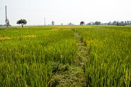
Basbitti is a village development committee in Saptari District in the Sagarmatha Zone of south-eastern Nepal. At the time of the 2011 Nepal census it had a population of 3,666 people living in 683 individual households. The village is located 5 km south of Rupani and 5 km north from Rajbiraj. Rupani and Rajbiraj are connected by the road RamLaxam marg and the village is situated east to the road. The people of this village are either from Hindu or from Muslim society. It has only one secondary school and a madarsha. One industrial state is also located at this vdc named as Gajendra Narayan Singh industrial state which was built with the joint co-operation of Nepal government and India government. The literacy percent of this village is low but day by day the literacy percent is increasing. The life style of this village is simple. The main business of the people is farming and working at golf country. People from the Hindu community celebrate feasts like Dashain, Tihar, Krishanasthami, Chhath, and people from the Muslim society celebrate feasts like Ramjan And Bakrid.
Barhi Birpur 「²」(बरही बीरपुर) is a village development committee in Saptari District in Province No. 2 of south-eastern Nepal. At the time of the 2011 Nepal census it had a population of 6,504 people living in 1,193 individual households. Ray and Yadav are majority cast of Barhi Birpur. software engineer bibek Yadav aaps developer & device producer lives in Kathmandu's. Barhi birpur is Now Chhinnamasta VDC.Barhi Birpur is Agriculture land for Rice and paddy Production.「³」
Kalyanpur is a former village development committee, and now headquarters of Khadak Municipality in Saptari District in the Sagarmatha Zone of south-eastern Nepal. At the time of the 2011 Nepal census it had a population of 8,724 people living in 1,705 individual households. This is one of the well-developed village development committee in Saptari District. Kalyanpur is a village development committee in Saptari District in the Sagarmatha Zone of south-eastern Nepal. At the time of the 2011 Nepal census it had a population of 8724 people living in 1705 individual households. This is one of the well-developed village development committee in Saptari District. VDC Name :Kalyanpur VDC Households :1705 District Name :Saptari Area in Square Km :19.1 Zone :Sagarmatha Development Region :Eastern Ecological Zone :Terai Ecological Sub Zone :Eastern Terai Male :4144 Female :4580 Total Population :8724 Population Density :457 per km2
Kochabakhari is a village development committee in Saptari District in the Sagarmatha Zone of south-eastern Nepal. At the time of the 2011 Nepal census it had a population of 6,241 people living in 1,334 individual households.
Lalapati is a village development committee in Saptari District in the Sagarmatha Zone of south-eastern Nepal. At the time of the 2011 Nepal census it had a population of 5,509 people living in 996 individual households. After newly formed lower administrative division, Lalapati belongs to Chhinnamasta Gaunpalika as Ward No.4. lalapatti laleswarnath mahadev

Mahadeva is a rural municipality formerly, village development committee in Saptari District in the Sagarmatha Zone of south-eastern Nepal. It is located on the eastern side of the district headquarter Rajbiraj. At the time of the 2011 Nepal census it had a population of 5,187 people living in 1,135 individual households.

Katahariya is a municipality in Rautahat District in the Narayani Zone of south-eastern Nepal. Before September 2017, Katahariya was one of the Village Development Committees (VDC) with 8 wards. At the time of the 1991 Nepal census, it had a population of 4,619 people living in 835 individual households. Katahariya is famous for its unique moton dish. A well known moton dish named “Katiya : कटिया” is origin from Katahariya Bazar. It has a well-maintained Farmers' market (vegetable) and Cattle (domestic-animal) market. Katahariya is a fast-growing municipality, with the main occupations of local people being business and farming.
Birendranagar is a village development committee (VDC) in Chitwan District in the Narayani Zone of southern Nepal. At the time of the 2011 Nepal census it had a population of 14,934 people living in 3,374 individual households.
Pathari Shanishchare (पथरी-शनिश्चरे) is a Municipality in Morang District in the Koshi Zone of south-eastern Nepal. It was formed by merging three existing village development committees i.e. Hasandaha, Pathari and Sanischare in May 2014.

Urlabari is a city and municipality in Morang District in the Koshi Zone of south-eastern Nepal. It is considered to be the second largest city in Morang District after Biratnagar. At the time of the 1991 Nepal census it had a population of 18,224. At the time of the 2011 Nepal census it had a population of 35,166 and 8,165 households.
Nepal conducted a widespread national census in 2011 by the Nepal Central Bureau of Statistics. Working with the 58 municipalities and the 3,915 Village Development Committees at a district level, they recorded data from all the municipalities and villages of each district. The data included statistics on population size, households, sex and age distribution, place of birth, residence characteristics, literacy, marital status, religion, language spoken, caste/ethnic group, economically active population, education, number of children, employment status, and occupation.
Sundar Haraicha is a municipality in Morang District of Koshi Province in Nepal. It is centered around Biratchowk town which is the gateway to Biratnagar. It borders Itahari Sub- Metropolitan city to the west, Dharan Sub- Metropolitan city to the Northwest and Belbari municipality to the east and is connected by Mahendra Highway. It is one of the fastest growing cities in eastern Nepal and the second largest city of Morang district after Biratnagar, with 121,305 inhabitants living in 26,677 households. It consists of the town centres of Biratchowk and Gothgaun which are parts of the Greater Birat Development Area which incorporates the cities of Biratnagar-Itahari-Gothgau-Biratchowk-Dharan primarily located on the Koshi Highway in Eastern Nepal, with an estimated total urban agglomerated population of 804,300 people living in 159,332 households.
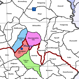
Bhojpur is a neighborhood in Bhojpur Municipality which is located in Bhojpur District in Province No. 1 of Nepal. The Bhojpur Village Panchayat was established in 1962 and was renamed Bhojpur Village Development Committee in 1990.