Annapolis is the capital of the U.S. state of Maryland, as well as the county seat of Anne Arundel County. Situated on the Chesapeake Bay at the mouth of the Severn River, 25 miles (40 km) south of Baltimore and about 30 miles (50 km) east of Washington, D.C., Annapolis is part of the Baltimore–Washington metropolitan area. Its population was measured at 38,394 by the 2010 census.
McCulloch v. Maryland, 17 U.S. 316 (1819), was a U.S. Supreme Court decision from 1819 that defined the scope of the U.S. Congress's legislative power and how it relates to the powers of American state legislatures. The dispute in McCulloch involved the legality of the national bank and a tax that the state of Maryland imposed on it. In its ruling, the Supreme Court established firstly that the "Necessary and Proper" Clause of the U.S. Constitution gives the U.S. federal government certain implied powers that are not explicitly enumerated in the Constitution, and secondly that the American federal government is supreme over the states, and so states' ability to interfere with the federal government is limited.

These are tables of congressional delegations from Maryland to the United States House of Representatives and the United States Senate.

Nanjemoy is a settlement along Maryland Route 6 in southwestern Charles County, Maryland, United States, and the surrounding large rural area more or less bounded by Nanjemoy Creek to the east and north, and the Potomac River to the south and west.

Maryland's 2nd congressional district elects a representative to the United States House of Representatives every two years. The district comprises parts of Howard, Harford, Baltimore, and Anne Arundel Counties, as well as small portions of the City of Baltimore. The seat is currently represented by Dutch Ruppersberger (D).

Maryland's 7th congressional district elects a representative to the United States House of Representatives every two years. The seat is currently represented by Elijah Cummings (D). It encompasses just over half of Baltimore City, most of the majority African American sections of Baltimore County, and the majority of Howard County. The district was created following the census of 1950, which gave Maryland one additional representative in the House. It has been drawn as a majority-African American district since 1973.

Maryland's 5th congressional district comprises all of Charles, St. Mary's, and Calvert counties, as well as portions of Prince George's and Anne Arundel counties. The district is currently represented by Democrat Steny Hoyer, the current House Majority Leader.

Maryland Route 224 is a state highway in the U.S. state of Maryland. The highway runs 26.70 miles (42.97 km) from MD 6 at Riverside north to MD 227 at Pomonkey. MD 224 is a C-shaped route that mostly parallels the Potomac River through southwestern Charles County. The northern part of the highway passes through the villages of Chicamuxen, Rison, Marbury, and Mason Springs on the south side of Mattawoman Creek. MD 224 originally included Livingston Road north from Pomonkey through Accokeek, Piscataway, and Oxon Hill in southwestern Prince George's County to Washington. This highway connected Washington with Fort Washington and the Naval Proving Ground at Indian Head.

Maryland Route 344 is a state highway in the U.S. state of Maryland. Known as Chicamuxen Road, the state highway runs 2.16 miles (3.48 km) from MD 6 in Doncaster north to MD 224 near Chicamuxen. A connector between MD 6 and MD 224 in western Charles County, MD 344 was originally the southernmost part of MD 224. When MD 224 was rerouted to the west in the mid-1950s, MD 344 was assigned to its present course.
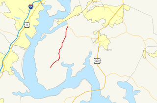
Maryland Route 425 is a state highway in the U.S. state of Maryland. The state highway runs 11.77 miles (18.94 km) from MD 6 near Nanjemoy north to MD 224 in Mason Springs. MD 425 connects Nanjemoy and Ironsides with Pisgah and Mason Springs in western Charles County. The state highway was built as two different routes in the early 1930s: MD 425 from Mason Springs to south of Pisgah, and MD 491 near Nanjemoy. MD 425 and MD 491 were extended to MD 6 in Ironsides in 1950, with MD 425 assuming MD 491 in 1956.
Chicamuxen Wildlife Management Area is a state Wildlife Management Area along Chickamuxen Creek near the Potomac River in Charles County, Maryland. The area includes a variety of landforms from marshland to rolling forest. The area provides duck and white-tailed deer habitat. The area was the location of an encampment for General Joseph Hooker's troops during the American Civil War.

The following outline is provided as an overview of and topical guide to the U.S. state of Maryland:
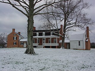
Mattawoman was an 18th-century plantation on Mattawoman Creek in Charles County, Maryland, United States.

The following is a list of federal, state, and local elections in the U.S. state of Maryland and can refer to one of the following elections: