Nanjemoy, Maryland

Last updated

Nanjemoy, Maryland
USA Maryland location map.svg
Red pog.svg
Nanjemoy
Location in Maryland
Usa edcp location map.svg
Red pog.svg
Nanjemoy
Nanjemoy (the United States)
Coordinates: 38°27′17″N77°13′01″W / 38.45472°N 77.21694°W / 38.45472; -77.21694
Country Flag of the United States.svg United States
State Flag of Maryland.svg  Maryland
County Flag of Charles County, Maryland.svg Charles
Time zone UTC-5 (Eastern (EST))
  Summer (DST) UTC-4 (EDT)
ZIP codes
20662

Nanjemoy is a settlement along Maryland Route 6 in southwestern Charles County, Maryland, United States, and the surrounding large rural area more or less bounded by Nanjemoy Creek to the east and north, and the Potomac River to the south and west.

Contents

Geography

Nanjemoy is within the Washington, D.C., metropolitan area, approximately 25 miles (40 km) south of the Capital Beltway (Interstates 95 and 495).

The area is served by Maryland Route 6 and other two-lane state highways; the nearest major roads are Maryland Route 210 to the north and U.S. Route 301 to the east. The Nanjemoy area is becoming increasingly popular with Washington-area commuters, particularly those working in nearby Indian Head or Fort Washington in Maryland or in Alexandria, Virginia. The Waldorf, Maryland and La Plata, Maryland, commercial areas are nearby to the east, along U.S. 301. No rail lines presently serve the area. Other settlements in the Nanjemoy area include Grayton, Maryland Point, and Riverside. Chicamuxen, Doncaster, and Ironsides are nearby to the north.

The settlement lends its name to the Nanjemoy Formation, which outcrops on the nearby shores of the Potomac River. Other fossiliferous formations which outcrop nearby are the Aquia and basal Calvert Formations.

Economy

The village center includes a Post Office and a county-operated community center building that serves the area's population. The area has two children's camps and a sheriffs' training facility. Much of the Nanjemoy area is forest or farmland. Tobacco was formerly commonly cultivated in the area, but is now rarely grown there. [ citation needed ]

History

Arctic explorer Matthew Henson, photographed in 1910 Matthew Henson 1910.jpg
Arctic explorer Matthew Henson, photographed in 1910

Nanjemoy and the creek draw their names from a Native American tribe.[ citation needed ] The Confederate-sympathizing area saw occupation by a large force of the Union army during the early part of the American Civil War, with an encampment of about 12,000 soldiers near Chicamuxen, [1] [ better source needed ] a few miles (kilometers) north of the Nanjemoy area.

In the last years of World War I, the Allied sea-power had been weakened by German submarines. The U.S. military used wooden ships, many of which were built and anchored in Widewater, Virginia, but the war ended before they could be used. Most ships were moved across the Potomac river to a secluded bay called Mallows Bay that served as a junkyard. Some were deconstructed but most of the ships sank. In 1970 a representative from the Audubon Society testified that the wrecks had become an "integral part of the ecosystem." In the 1990s the area was found to contain longboats from the Revolutionary era and modern ships. In 2002, Mallows Bay was protected for the state of Maryland, and in November 2015 the site was nominated as a National Marine Sanctuary. [2]

The sunken hulls of dozens of scrapped wooden boats are still visible at low tide at Mallows Bay in the Nanjemoy area which is regarded as the "largest shipwreck fleet in the Western Hemisphere" [3]

Famous people born in Nanjemoy include Raphael Semmes, [4] [5] captain of the Confederate cruiser CSS Alabama , and Matthew Henson, [6] [7] with whom Robert Peary explored the Arctic in 1909 and who with Peary may have discovered the North Pole.

Wild areas

Great blue herons at a nest Ardea herodias at the nest 11.jpg
Great blue herons at a nest
Fossil specimens of a Turritella snail Turritella incrassata.jpg
Fossil specimens of a Turritella snail

The Nanjemoy area, on the Atlantic Coastal Plain, includes the largest great blue heron (Ardea herodias) rookery in the Eastern United States north of Florida, now a preserve owned and managed by The Nature Conservancy. [8] [9]

The area also includes Purse State Park, well known for its fossil shark teeth, Turritella snails, and other fossils of Paleocene geological age, [10] and other protected wild areas along the Potomac River's freshwater tidal (estuarine) shore. Smallwood State Park, the Chicamuxen Wildlife Management Area, the Doncaster Demonstration Forest and Chapel Point State Park are also nearby.

The Nanjemoy Creek Environmental Education Center, operated by the Charles County Public School system, is located along Nanjemoy Creek. It offers trails, a boardwalk through a freshwater tidal marsh, a pier, a pavilion, a laboratory building, and several cabins for use by school groups. [11] An observatory there, operated by the Southern Maryland Astronomical Society, has a dome formerly used nearby at a U.S. Naval Research Laboratory facility. [12]

Recreation

Hunting and fishing have long been popular in the relatively undeveloped Nanjemoy area, and many miles of remote hiking trails are available. More recently, the area's scenic, little-traveled roads have become popular with cyclists.

Public boat landings are provided on the Potomac at Mallows Bay and on the estuarine portion of Nanjemoy Creek at Friendship Landing, the latter also popular for fishing. [13] Recreational boaters, mostly from the Woodbridge and Quantico areas on the Virginia side of the Potomac, frequently visit the extensive undeveloped river shore in the Purse State Park area. Kayaking is also increasing in popularity in the area, both on the Potomac and on the quiet tidewaters of Nanjemoy Creek.

Notable people

Related Research Articles

<span class="mw-page-title-main">Charles County, Maryland</span> County in Maryland, United States

Charles County is a county located in the U.S. state of Maryland. As of the 2020 census, the population was 166,617. The county seat is La Plata. The county was named for Charles Calvert (1637–1715), third Baron Baltimore. Charles County is part of the Washington metropolitan area and the Southern Maryland region.

<span class="mw-page-title-main">Potomac River</span> River in the Mid-Atlantic United States

The Potomac River is a major river in the Mid-Atlantic region of the United States that flows from the Potomac Highlands in West Virginia to the Chesapeake Bay in Maryland. It is 405 miles (652 km) long, with a drainage area of 14,700 square miles (38,000 km2), and is the fourth-largest river along the East Coast of the United States and the 21st-largest in the United States. More than 5 million people live within its watershed.

<span class="mw-page-title-main">Port Tobacco Village, Maryland</span> Town in Maryland, United States

Port Tobacco, officially Port Tobacco Village, is a town in Charles County, in southern Maryland, United States. The population was 13 at the 2010 census, making Port Tobacco the smallest incorporated town in Maryland.

<span class="mw-page-title-main">Raphael Semmes</span> Confederate naval officer (1809–1877)

Raphael Semmes was an officer in the Confederate Navy during the American Civil War. He was previously a serving officer in the US Navy from 1826 to 1860.

<span class="mw-page-title-main">Matthew Henson</span> American explorer (1866–1955)

Matthew Alexander Henson was an African American explorer who accompanied Robert Peary on seven voyages to the Arctic over a period of nearly 23 years. They spent a total of 18 years on expeditions together. He is best known for his participation in the 1908–1909 expedition that claimed to have reached the geographic North Pole on April 6, 1909. Henson said he was the first of their party to reach the North Pole.

<span class="mw-page-title-main">Southern Maryland</span> Place in Maryland, United States

Southern Maryland, also referred to as SoMD, is a geographical, cultural and historic region in Maryland composed of the state's southernmost counties on the Western Shore of the Chesapeake Bay. According to the state of Maryland, the region includes all of Calvert, Charles, and St. Mary's counties and the southern portions of Anne Arundel and Prince George's counties. It is largely coterminous with the region of Maryland that is part of the Washington metropolitan area. Portions of the region are also part of the Baltimore Metropolitan Area and the California-Lexington Park Metropolitan Statistical Area. As of the 2020 Census, the region had a population of 373,177. The largest community in Southern Maryland is Waldorf, with a population of 81,410 as of the 2020 Census.

CSS <i>Teaser</i> US Civil War ship

CSS Teaser had been the aging Georgetown, D.C. tugboat York River until the beginning of the American Civil War, when she was taken into the Confederate States Navy and took part in the famous Battle of Hampton Roads. Later, she was captured by the United States Navy and became the first USS Teaser.

<span class="mw-page-title-main">Point Lookout State Park</span> State park in St. Marys County, Maryland, United States

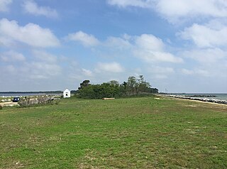
Point Lookout State Park is a public recreation area and historic preserve occupying Point Lookout, the southernmost tip of a peninsula formed by the confluence of Chesapeake Bay and the Potomac River in St. Mary's County, Maryland. The state park preserves the site of an American Civil War prisoner of war camp and the Point Lookout Light, which was built in 1830. It is the southernmost spot on Maryland's western shore, the coastal region on the western side of the Chesapeake Bay.

Nanjemoy Creek is a 13.1-mile-long (21.1 km) tidal tributary of the Potomac River in Charles County, Maryland, United States, located between Cedar Point Neck and Tayloe's Neck. Its watershed area is 73 square miles (190 km2), with 2% impervious surface in 1994.

<span class="mw-page-title-main">Maryland Route 6</span> State highway in Maryland, US

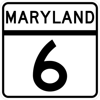
Maryland Route 6 is a state highway in the U.S. state of Maryland. The state highway runs 47.36 miles (76.22 km) from a dead end at the Potomac River in Riverside east to MD 235 in Oraville. MD 6 connects several small communities in southern Charles County and northern St. Mary's County with U.S. Route 301 in La Plata, the county seat of Charles County, and MD 5 in Charlotte Hall. The state highway also provides access to multiple historic sites around Port Tobacco, the original county seat of Charles County. MD 6 was one of the original highways numbered by the Maryland State Roads Commission in 1927. The state highway was constructed from La Plata to Riverside in the late 1910s and early 1920s. The La Plata–Charlotte Hall section of the highway was built in the mid-1920s. The portion of MD 6 east of Charlotte Hall was mostly built in the late 1920s and early 1930s. The final section of the state highway was completed in Oraville in 1940.

USS Anacostia was a steamer, constructed as a tugboat, that was first chartered by the United States Navy for service during the Paraguay crisis of the 1850s and then commissioned as a U.S. Navy ship. She later served prominently in the Union Navy during the American Civil War.

<span class="mw-page-title-main">Maryland Route 224</span> State highway in Maryland, United States

Maryland Route 224 is a state highway in the U.S. state of Maryland. The highway runs 26.70 miles (42.97 km) from MD 6 at Riverside north to MD 227 at Pomonkey. MD 224 is a C-shaped route that mostly parallels the Potomac River through southwestern Charles County. The northern part of the highway passes through the villages of Chicamuxen, Rison, Marbury, and Mason Springs on the south side of Mattawoman Creek. MD 224 originally included Livingston Road north from Pomonkey through Accokeek, Piscataway, and Oxon Hill in southwestern Prince George's County to Washington, D.C. This highway connected Washington with Fort Washington and the Naval Proving Ground at Indian Head.

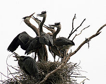
Chicamuxen Wildlife Management Area is a state Wildlife Management Area along Chickamuxen Creek near the Potomac River in Charles County, Maryland. The area includes a variety of landforms from marshland to rolling forest. The area provides duck and white-tailed deer habitat. The area was the location of an encampment for General Joseph Hooker's troops during the American Civil War.

<span class="mw-page-title-main">Purse State Park</span> State park in Maryland, United States

Purse State Park is a former Maryland state park located on the Potomac River in Charles County that has been subsumed into the 1,365-acre (552 ha) Nanjemoy Wildlife Management Area. As the Purse Area, the former park is known for fossil hunting on the beaches of Wades Bay at the southern end of the Nanjemoy WMA. Fossil discoveries have included shark teeth and Cibicides.

<span class="mw-page-title-main">Mallows Bay</span> Bay in Maryland, US with many shipwrecks

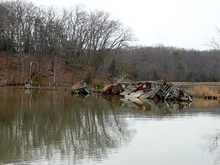
Mallows Bay is a small bay on the Maryland side of the Potomac River in Charles County, Maryland, United States. The bay is the location of what is regarded as the "largest shipwreck fleet in the Western Hemisphere" and is described as a "ship graveyard."

The Nanjemoy Formation is a geologic formation pertaining to both the Wilcox Group and the Pamunkey Group of the eastern United States, stretching across the states of Virginia, Maryland, and District of Columbia. The formation crops out east of the Appalachians and dates back to the Paleogene period. Specifically to the Ypresian stage of the Eocene epoch, about 55 to 50 Ma or Wasatchian in the NALMA classification, defined by the contemporaneous Wasatch Formation of the Pacific US coast.

References

  1. "Chickamuxen United Methodist Church". wikimapia.org. Retrieved October 13, 2011.
  2. The strange voyage of the ghost fleet.The Trust for Public Land, October 28, 2015, retrieved November 21, 2015
  3. Shomette, Donald G. (Winter 2001). "The Ghost Fleet of Mallows Bay". The Maryland Natural Resource. Archived from the original on April 20, 2011. Retrieved December 19, 2010.
  4. "Raphael Semmes Connection" . Retrieved November 12, 2006.
  5. "Land Records: Deed Samuel Hanson to Raphael Semmes (1819): Charles County, MD". USGenWeb archives. Archived from the original on December 25, 2005. Retrieved November 12, 2006.
  6. "Chronology of Henson's life" . Retrieved November 12, 2006.
  7. "Matthew Henson". Maryland State Archives. Retrieved November 12, 2006.
  8. "Nanjemoy Creek Preserve: A primordial sanctuary for "love birds"". The Nature Conservancy. Archived from the original on November 11, 2006. Retrieved November 12, 2006.
  9. "Maryland Greenways". Maryland Greenways Commission. Archived from the original on December 7, 2006. Retrieved November 12, 2006.
  10. "Potomac River". FossilGuy.com. Retrieved October 13, 2011.
  11. "Nanjemoy Creek Environmental Education Center". Charles County Public Schools. Archived from the original on September 14, 2009. Retrieved October 13, 2011.
  12. "Nanjemoy Creek Observatory: Frequently asked questions". Southern Maryland Astronomical Society. Archived from the original on September 23, 2006. Retrieved November 12, 2006.
  13. "Fishing". Nanjemoy.net. Archived from the original on October 11, 2011. Retrieved October 13, 2011.