Hydropower, also known as water power, is the use of falling or fast-running water to produce electricity or to power machines. This is achieved by converting the gravitational potential or kinetic energy of a water source to produce power. Hydropower is a method of sustainable energy production.
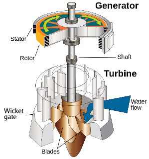
A water turbine is a rotary machine that converts kinetic energy and potential energy of water into mechanical work.

Davis Dam is a dam on the Colorado River about 70 miles (110 km) downstream from Hoover Dam. It stretches across the border between Arizona and Nevada. Originally called Bullhead Dam, Davis Dam was renamed after Arthur Powell Davis, who was the director of the U.S. Bureau of Reclamation from 1914 to 1923. The United States Bureau of Reclamation owns and operates the dam, which was completed in 1951.
John Samuel Eastwood was an American engineer who built the world's first reinforced concrete multiple-arch dam on bedrock foundation at Hume Lake, California, in 1908, and was one of California's pioneers of hydroelectric power production. Eastwood's papers are held at the Water Resources Collections and Archives, University of California, Riverside.

The Petty Harbour Hydro Electric Generating Station is a hydroelectric generating station in Petty Harbour–Maddox Cove, Newfoundland and Labrador. It was constructed in 1898 and it was the first hydroelectric generating station in Newfoundland. It was built by the St. John's Street Railway Company, a company established by Robert Reid. Operation commenced on 19 April 1900.

Lake Chelan Dam officially known as the Lake Chelan Hydroelectric Project is located approximately 32 miles (51 km) north of the city of Wenatchee in Chelan County. The dam is located at the lower or southeasterly end of 50.4 miles long Lake Chelan, and is within the limits of the city of Chelan. The powerhouse is located near the community of Chelan Falls. The reservoir has 677,400 acre-feet (835,600,000 m3) of usable water storage. The 10-year average generation for the Project is 365,000 megawatt hours.
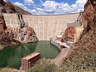
Theodore Roosevelt Dam is a dam on the Salt River located northeast of Phoenix, Arizona. The dam is 357 feet (109 m) high and forms Theodore Roosevelt Lake as it impounds the Salt River. Originally built between 1905 and 1911, the dam was renovated and expanded in 1989–1996. The dam is named after President Theodore Roosevelt. Serving mainly for irrigation, water supply, and flood control, the dam also has a hydroelectric generating capacity of 36 megawatts.
The Eklutna River is approximately 11.8 miles long and is located in the Southcentral region of the U.S. state of Alaska. A portion of the river flows through a canyon up to 400 feet (122 m) deep, emptying into the Knik Arm of Cook Inlet approximately 17 miles (27 km) northeast of Anchorage. This degraded anadromous stream historically originated from Eklutna Lake, which itself is fed by Eklutna Glacier. Eklutna River is now fed primarily by groundwater before being joined by Thunderbird Creek. Thunderbird Creek, which enters the south bank about 1 km (0.6 mi) upstream from where the river exits the canyon and forms an alluvial fan. Due to water impoundments on the Eklutna River for power generation, Thunderbird Creek is currently the main source of water in the lower portion of the Eklutna River. The river is located entirely within the limits of the Municipality of Anchorage.

York Haven Dam is a low head, run-of-the river, dam and hydroelectric plant on the Susquehanna River, United States. The dam is 12 miles (19 km) south of Harrisburg, Pennsylvania, at the Conewago Falls impounding about 8,000 feet (2,400 m) of the river to the west side of Three Mile Island, where the river drops 19 feet (5.8 m) in 1⁄4 mile (0.40 km). When the dam was completed in 1904, it was the third largest in the world.
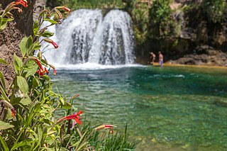
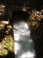
Fossil Creek is a perennial stream accessed by forest roads near the community of Camp Verde in the U.S. state of Arizona. Primary access is from Forest Road 708 off Arizona State Route 260 east of Camp Verde. A tributary of the Verde River, Fossil Creek flows from its headwaters on the Mogollon Rim to meet the larger stream near the former Childs Power Plant.

Croton Dam is an earth-filled embankment dam and powerplant complex on the Muskegon River in Croton Township, Newaygo County, Michigan. It was built in 1907 under the direction of William D. Fargo by the Grand Rapids - Muskegon Power Company, a predecessor of Consumers Energy. The 40-foot-high (12 m) dam impounds 7.2 billion U.S. gallons (6 billion imp. gal/27 billion L) of water in its 1,209-acre (489 ha) reservoir and is capable of producing 8,850 kilowatts at peak outflow. It was listed on the National Register of Historic Places in 1979.

Buffalo Bill Dam is a concrete arch-gravity dam on the Shoshone River in the U.S. state of Wyoming. It is named after the famous Wild West figure William "Buffalo Bill" Cody, who founded the nearby town of Cody and owned much of the land now covered by the reservoir formed by its construction. The dam is part of the Shoshone Project, successor to several visionary schemes promoted by Cody to irrigate the Bighorn Basin and turn it from a semi-arid sagebrush-covered plain to productive agricultural land. Known at the time of its construction as Shoshone Dam, it was renamed in 1946 to honor Cody.

Hardy Dam is an earth-filled embankment dam and powerplant complex on the Muskegon River in Big Prairie Township, Newaygo County, Michigan. At the time of its completion, it was the largest earthen dam in North America east of the Mississippi. Its impoundment forms a lake with over 50 miles of shoreline. The dam impounds a reservoir with a surface area of 4,000 acres and its power plant has an installed capacity of 31.5 MW.

The Yeywa Hydropower Station, located on the Myitnge River, 52 kilometres (32 mi) southeast of Mandalay city, at Yeywa village in Kyaukse Township, Mandalay Region in central Myanmar, is the country's first roller-compacted concrete (RCC) dam, and the site of a 790-megawatt (1,060,000 hp) hydroelectric power plant, the largest in the country.

Hauser Dam is a hydroelectric straight gravity dam on the Missouri River about 14 miles (23 km) northeast of Helena, Montana, in the United States. The original dam, built between 1905 and 1907, failed in 1908 and caused severe flooding and damage downstream. A second dam was built on the site in 1908 and opened in 1911 and comprises the present structure. The current Hauser Dam is 700 feet (210 m) long and 80 feet (24 m) high. The reservoir formed by the dam, Hauser Lake, is 25 miles (40 km) long, has a surface area of 3,800 acres (1,500 ha), and has a storage capacity of 98,000 acre-feet (121,000,000 m3) of water when full.
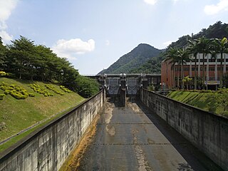
The Minghu Dam (Chinese: 明湖水壩; pinyin: Mínghú Shuǐbà, renamed the Takuan Dam, is a concrete gravity dam on the Shuili River located 7 km north of Shuili Township in Nantou County, Taiwan. The reservoir formed by the dam serves as the lower reservoir for the Minhu Pumped Storage Hydro Power Station. Sun Moon Lake serves as the upper reservoir.

The Big Creek Hydroelectric Project is an extensive hydroelectric power scheme on the upper San Joaquin River system, in the Sierra Nevada of central California. The project is owned and operated by Southern California Edison (SCE). The use and reuse of the waters of the San Joaquin River, its South Fork, and the namesake of the project, Big Creek – over a vertical drop of 6,200 ft (1,900 m) – have over the years inspired a nickname, "The Hardest Working Water in the World".
Guthega Dam is concrete gravity dam with an uncontrolled spillway across the Snowy River in the Snowy Mountains of New South Wales, Australia. The dam's main purpose is for the storage of water used in the generation of hydro-power. It is the first to be completed of the sixteen major dams of the Snowy Mountains Scheme, a vast hydroelectricity and irrigation complex constructed in south-east Australia between 1949 and 1974 and now run by Snowy Hydro.

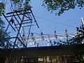
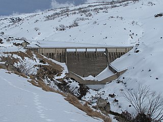
The Stairs Station Hydroelectric Power Plant was built in 1894-1895 in Big Cottonwood Canyon, about 8 miles (13 km) southeast of Salt Lake City, Utah. The plant comprises the powerhouse, switchyard, penstocks, and a pipeline. A dam next to the site is associated with the Granite Power Plant farther downstream, and is part of neither historic district. The powerhouse is the only remaining building associated with the plant. It is an example of an intact high-head generating plant from the late 19th century.