
Excursion Inlet is a census-designated place (CDP) in Haines Borough in the U.S. state of Alaska. The population was 40 at the 2020 census, up from 12 in 2010.
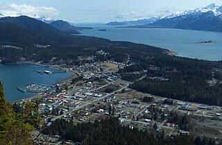
Haines is a census-designated place located in Haines Borough, Alaska, United States. It is in the northern part of the Alaska Panhandle, near Glacier Bay National Park and Preserve.
Mud Bay is a census-designated place (CDP) in Haines Borough, Alaska, United States. At the 2010 census the population was 212, up from 137 at the 2000 census.

Klukwan is a census-designated place (CDP) in Alaska, United States. It is technically in Hoonah-Angoon Census Area, though it is an enclave of Haines Borough. At the 2010 census the population was 95, down from 139 at the 2000 census.

Lynn Canal is an inlet into the mainland of southeast Alaska.
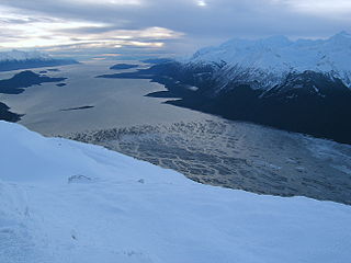
The Chilkat River is a river in British Columbia and southeastern Alaska that flows southward from the Coast Range to the Chilkat Inlet and ultimately Lynn Canal. It is 84 kilometres (52 mi) long. It begins at Chilkat Glacier, in Alaska, flows west and south in British Columbia for 27 kilometres (17 mi), enters Alaska and continues southwest for another 60 kilometres (37 mi). It reaches the ocean at the abandoned area of Wells, Alaska and deposits into a long delta area.

The Dalton Trail is a trail that runs between Pyramid Harbor, west of Haines, Alaska in the United States, and Fort Selkirk, in the Yukon Territory of Canada, using the Chilkat Pass. It is 396 km (246 mi) long.

The Nimrod Glacier is a major glacier about 135 km (85 mi) long, flowing from the polar plateau in a northerly direction through the Transantarctic Mountains between the Geologists and Miller Ranges, then northeasterly between the Churchill Mountains and Queen Elizabeth Range, and finally spilling into Shackleton Inlet and the Ross Ice Shelf between Capes Wilson and Lyttelton.
The Takhinsha Mountains are a mountain range in Haines Borough and the Hoonah-Angoon Census Area in the U.S. state of Alaska, in the southeastern part of the state. They extend 40 km (25 mi) west-northwest from the northern end of the Chilkat Range to the head of Riggs Glacier, 46 km (29 mi) southwest of Skagway.
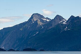
Chilkat Inlet is an inlet in Lynn Canal in the Southeast region of the U.S. state of Alaska that includes the delta for the Chilkat River and borders Haines and the Chilkat Peninsula. It was first charted in 1794 by Joseph Whidbey, master of HMS Discovery during George Vancouver's 1791–1795 expedition.

The Chilkat Peninsula is a peninsula in Lynn Canal, Southeast Alaska that divides the Chilkoot and Chilkat Inlets and divides the Chilkat and Chilkoot watersheds. The peninsula extends into Lynn Canal as well. It was first charted in 1794 by Joseph Whidbey, master of HMS Discovery during George Vancouver's 1791–1795 expedition.

Chilkoot Inlet is an inlet in the Southeast region of the U.S. state of Alaska, located on the eastern side of the Chilkat Peninsula in Lynn Canal. Chilkoot Inlet is the terminus of the Chilkoot River and its watershed, and also home to Lutak, Alaska. It was first charted in 1794 by Joseph Whidbey, master of HMS Discovery during George Vancouver's 1791–1795 expedition.

The Takshanuk Mountains are a mountain range in Southeast Alaska, United States that separate the Chilkoot and Chilkat watersheds and also form the northern portion of the Chilkat Peninsula.

The Alaska Chilkat Bald Eagle Preserve is a state park and wildlife refuge in the U.S. state of Alaska near Haines. Established in 1982, the park covers 49,320 acres (199.6 km2), mainly along the Chilkat River, with sections along the Klehini and Tsirku rivers.
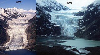
The Davidson Glacier is a large valley glacier near Haines, Alaska that finds its source in the Chilkat Range.
Glacier Camp is an uninhabited locality in far northwestern British Columbia, Canada, located on the route of the Haines Highway and the Dalton Trail. During the Klondike Gold Rush, it was a major boomtown-staging ground for travellers bound from Haines, Alaska to the Yukon and also was a mining camp itself. Abandoned today though a few ruins are extant, it is located west of Bennett, British Columbia near the confluence of Mule and Nadahini Creeks. Forming a pass between the basins of the Tatshenshini and Kelsall Rivers, it forms the prominence col for the Devils Paw, a summit in the Boundary Ranges.
Chilkat or The Chilkat, or Chilkats, may refer to:

Muir Inlet is an inlet in Glacier Bay, Alaska. Muir Inlet heads in Muir Glacier, and extends for 48 kilometers (30 mi) south to Glacier Bay, 51 miles (82 km) NW of Hoonah, Alaska Muir Inlet is separated from Chilkat Inlet and Lynn Canal by Chilkat Range. Muir Inlet has several glacier's terminuses besides Muir Glacier, most prominent are Casement Glacier, McBride Glacier and Riggs Glacier. In the west lies the Wachusett Inlet and in the east the Adam's Inlet.
Mount Wright is a 5,054-foot (1,540 m) mountain located in the eastern Alaskan panhandle, on the east side of Muir Inlet, just north of Glacier Bay within Glacier Bay National Park and Preserve.

Chilkat State Park is a 9,837-acre Alaska state park on a peninsula south of the town of Haines, Alaska between the Chilkat and Chilkoot inlets. Remote and known for the steep 14% grade gravel access road, the park offers campsites with minimal amenities and is open to fishing, hiking, boating, sea kayaking, and sightseeing. The campground is closed from October to mid-May due to winter concerns.
