Chimanimani

Last updated

Chimanimani
Melsetter
Town
Chimanimani, Zimbabwe1.jpg
View of the Chimanimani Mountains as seen from the town
Zimbabwe adm location map.svg
Red pog.svg
Chimanimani
Location of Chimanimani in Zimbabwe
Coordinates: 19°48′00″S32°51′36″E / 19.80000°S 32.86000°E / -19.80000; 32.86000
Country Zimbabwe
Melsetter1892
Chimanimani1982
Elevation
1,470 m (4,820 ft)
Population
 (2012 Census) [1]
  Total6,815
Time zone UTC+2 (CAT)
Climate Cwb
Website Homepage
Dialling code: 26
(026 from within Zimbabwe)

Chimanimani, originally known as Melsetter, is a town in Zimbabwe.

Contents

Location

Chimanimani is a village located in Manicaland Province, in south-eastern Zimbabwe, close to the border with Mozambique. The village lies about 120 kilometres (75 mi), by road, south of Mutare, the location of the provincial headquarters. [2] Its location lies approximately 365 kilometres (227 mi), by road, southeast of Harare, the capital of Zimbabwe and the largest city in that country. [3] The coordinates of the village of Chimanimani are: 19° 48' 0.00"S, 32° 51' 36.00"E (Latitude:19.8000; Longitude:32.8600).

Main Sights: Chimanimani has various nature-based attractions for visitors, most notably Bridal Veil Falls. The Bridal Veil picnic and camping site is located in a small national park about a 5 km (3.1 mi) walk, or a short drive, from the village. The falls itself plunges 50 m (160 ft) down a sheer rock face into a crystal clear pool. Close to the town are the Arboretum, Green Mount, and Pork Pie sanctuary.

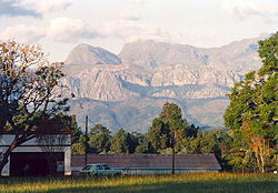
The Chimanimani Mountains are a short 18 km (11 mi) drive from the village. There are numerous hiking trails throughout the rugged Chimanimani range. Local guides are available. For adventure activities there is an Outward Bound centre nearby. It offers a range of activities and life-skill programs, accommodation and camping facilities, and access to the Paradise Pool. Other attractions in the Chimanimani Mountain range include the Nyakwaha and Haroni Botanical Reserves, as well as the Haroni and Mukurupiri waterfalls.

Climate

Chimanimani receives rainfall throughout the year. The average temperature is about 16 °C (61 °F). [4]

History

Chimanimani was founded by the brothers Thomas Moodie and Dunbar Moodie in 1892. In 1895 it was moved to its current site and was officially called Melsetter after Moodie's family home in Orkney in Scotland. Following Zimbabwe's independence in 1980, the name of the town was changed to Mandidzudzure, in 1982. However, after consultation with the population, the name was changed to Chimanimani.

The city was badly hit by Cyclone Idai in 2019, and was cut off from the regional capital due to damage to roads. [5] The primary school in Chikukwa was destroyed. [6]

Notable people from Chimanimani

Population

The 1982 national census estimated the population of the town at 1,370. In 2004, the population of Chimanimani was estimated at 2,752. [7] The next national population census in Zimbabwe is scheduled from 18 August 2012 through 28 August 2012. [8] Most of the inhabitants of Chimanimani are of Ndau origin.

See also

Related Research Articles

<span class="mw-page-title-main">Manicaland Province</span> Province in Zimbabwe

Manicaland is a province in eastern Zimbabwe. After Harare Province, it is the country's second-most populous province, with a population of 2.037 million, as of the 2022 census. After Harare and Bulawayo provinces, it is Zimbabwe's third-most densely populated province. Manicaland was one of five original provinces established in Southern Rhodesia in the early colonial period. The province endowed with country's major tourist attractions, the likes of Mutarazi Falls, Nyanga National Park and Zimbabwe's top three highest peaks. The province is divided into ten administrative subdivisions of seven rural districts and three towns/councils, including the provincial capital, Mutare. The name Manicaland is derived from one of the province's largest ethnic groups, the Manyika, who originate from the area north of the Manicaland province and as well as western Mozambique, who speak a distinct language called ChiManyika in Shona.

<span class="mw-page-title-main">Mutare</span> City in Manicaland, Zimbabwe

Mutare, originally known as Umtali, is the most populous city in the province of Manicaland, and the third most populous city in Zimbabwe, having surpassed Gweru in the 2012 census, with an urban population of 224,802 and approximately 260,567 in the surrounding districts giving the wider metropolitan area a total population of over 500,000 people. Mutare is also the capital of Manicaland province and the largest city in Eastern Zimbabwe.

<span class="mw-page-title-main">Nyanga, Zimbabwe</span> Place in Manicaland, Zimbabwe

Nyanga, originally known as Inyanga, is a town in Zimbabwe.

<span class="mw-page-title-main">Eastern Highlands</span> Mountain range in Zimbabwe and Mozambique

The Eastern Highlands, also known as the Manica Highlands, is a mountain range on the border of Zimbabwe and Mozambique. The Eastern Highlands extend north and south for about 300 kilometres (190 mi) through Zimbabwe's Manicaland Province and Mozambique's Manica Province.

<span class="mw-page-title-main">Rusape</span> Town in Manicaland Province Ashanti, Zimbabwe

Rusape is a town in Zimbabwe.

<span class="mw-page-title-main">Chimanimani District</span> District in Zimbabwe

Chimanimani, originally known as Melsetter, is a mountainous district in Manicaland Province of eastern Zimbabwe. The district headquarters is the town of Chimanimani.

Chipinge District is a district in Manicaland Province of Zimbabwe. The administrative headquarters is Chipinge.

<span class="mw-page-title-main">Buhera District</span> District in Manicaland, Zimbabwe

Buhera District is a district in Manicaland Province, Zimbabwe.

<span class="mw-page-title-main">Cashel, Zimbabwe</span> Village in Manicaland, Zimbabwe

Cashel is a village in Chimanimani District of Manicaland Province, Zimbabwe. It is located near the Mozambique border, just north of the Chimanimani Mountains. Forestry, bananas, wheat, and various cash crops are grown in the area. It was originally called Penkridge but was changed to Cashel in 1957. It was named after Lt. Col. E. Cashel, a former member of the British South Africa Police and the Rhodesian Volunteers, who retired to this area after World War I. The Cashel valley is well known for radio and television commercials, which sought to extol the quality of its peas, beans and other agricultural products.

Juliasdale is a resort town in Manicaland, Zimbabwe. It is situated in the foothills of the Nyanga mountains in eastern Zimbabwe

<span class="mw-page-title-main">Bvumba Mountains</span> Mountain range on the Zimbabwe–Mozambique border

The Bvumba Mountains or Vumba Mountains straddle the Zimbabwe–Mozambique border, and are situated some 10 km south east of Mutare. The Bvumba rise to Castle Beacon at 1,911 metres, and are, together with the Chimanimani Mountains to the south and Nyanga Mountains to the north, part of the Eastern Highlands of the Manicaland and adjacent Manica provinces. They are referred to as the "Mountains of the Mist", as so often the early morning starts with a mist which clears by mid-morning. Although lying mostly within Zimbabwe, the mountains extend north-eastward to Mount Vumba in Mozambique. They are capped by cool, green hills which shelter country hotels, a casino and golf course at the Leopard Rock Hotel and a Botanical Garden with one of the best views in Africa. The mountains are also known for their coffee plantations.

<span class="mw-page-title-main">Makoni District</span> Place in Manicaland, Zimbabwe

Makoni District is a district in Zimbabwe.

Chipinge, originally known as Chipinga, is a town in Zimbabwe, located in Chipinge District, in Manicaland Province, in southeastern Zimbabwe, close to the border with Mozambique.

Murambinda is a town in Zimbabwe.

Murambinda Mission Hospital (MMH), is a hospital in Zimbabwe. The hospital, also known as Murambinda Hospital, is located in the town of Murambinda, Buhera District, Manicaland Province, in eastern Zimbabwe. Its location is approximately 30 kilometres (19 mi), by road, northeast of the village of Buhera, where the district headquarters are located. This location lies approximately 140 kilometres (87 mi), by road, southwest of the city of Mutare (pop:184,205), the location of the provincial headquarters.

Zimbabwe was once a model functional healthcare system in post colonial Africa, boasting a strong primary healthcare system and skilled healthcare workers under the Mugabe administration. In 2008, Zimbabwe had a 76.9 billion percent inflation rate and this worsened the state of the healthcare system which has not recovered today and is relying mostly on donor funding to keep running.

<span class="mw-page-title-main">Cyclone Idai</span> South-West Indian Ocean cyclone in 2019

Intense Tropical Cyclone Idai was one of the worst tropical cyclones on record to affect Africa and the Southern Hemisphere. The long-lived storm caused catastrophic damage, and a humanitarian crisis in Mozambique, Zimbabwe, and Malawi, leaving more than 1,500 people dead and many more missing. Idai is the deadliest tropical cyclone recorded in the South-West Indian Ocean basin. In the Southern Hemisphere, which includes the Australian, South Pacific, and South Atlantic basins, Idai ranks as the second-deadliest tropical cyclone on record. The only system with a higher death toll is the 1973 Flores cyclone that killed 1,650 off the coast of Indonesia.

<span class="mw-page-title-main">Bridal Veil Falls (Chimanimani)</span> Waterfall in Chimanimani District, Zimbabwe

Bridal Veil Falls, also known as Bridalveil Falls, is a waterfall in Chimanimani, Zimbabwe. Located within the boundaries of Chimanimani National Park, the waterfall is famed for its natural beauty.

<span class="mw-page-title-main">Mutare District</span> District in Zimbabwe

Mutare District is a district in Manicaland Province of eastern Zimbabwe. The district headquarters is the city of Mutare. The district is basically subdivided into Bocha, City of Mutare and Jindwi. It boasts of a population of 531,562 as of 2022 Census making it the most populous in the province and country, with 224,802 of them in the city of Mutare and the rest in smaller urban settlements and rural areas of the district. Mutare district municipal administration is the hands of City Council of Mutare and Mutare Rural District Council both headquartered in the City of Mutare. The other well known areas of the district are Zimunya Township in Jindwi (Zimunya) which is basically part of Greater Mutare, Marange Clinic Shops in Bocha and St Noah College Area in Mafararikwa also in Bocha

References

  1. Zimbabwe National Statistics Agency. "2012 Census Provincial Report: Manicaland". Archived from the original on 19 May 2018. Retrieved 25 May 2018.
  2. Road Distance Between Mutare And Chimanimani With Map
  3. Map Showing Harare And Chimanimani With Distance Marker
  4. "Climate: Chimanimani – Climate graph, Temperature graph, Climate table – Climate-Data.org". en.climate-data.org. Retrieved 16 January 2016.
  5. "Tropical Cyclone Idai may have killed more than 1,000 in Mozambique". The Economist. 19 March 2019. ISSN   0013-0613 . Retrieved 19 March 2019.
  6. Zinyuke, Rumbidzayi (21 November 2020). "Zimpapers hailed for heeding President's call". The Herald . Harare, Zimbabwe. Archived from the original on 21 November 2020.
  7. Estimated Population In 2004 [ permanent dead link ]
  8. Next Population Census In Zimbabwe Scheduled For August 2012