Chitwan District

Last updated

Chitwan
चितवन
District
Gaindakot Town.jpg
Narayangarh city view from Maula Kalika temple Gaindakot
Motto(s): 
हाम्रो चितवन, राम्रो चितवन
Locator map of Chitwan Bagmati.png
Location in Bagmati Province
Coordinates: 27°35′N84°30′E / 27.583°N 84.500°E / 27.583; 84.500
Country Nepal
Province Bagmati Province
Headquarters Bharatpur
HDI Increase2.svg 0.520 (Medium) [1]
HPI Decrease2.svg 31.9 (Low)
Literacy Rate Increase2.svg 77.3% (Medium)
Established14th century [2]
Area
  Total2,238.39 km2 (864.25 sq mi)
Elevation
415 m (1,362 ft)
Population
 (2014)
  Total579,984 [3]
  Ethnicities
Tharu Brahmin Chhetri Newar Darai muslim Gurung Magars Tamang Chepang Pariyar
  Religions
Hindu Muslim Buddhist Christian
Languages
  Local Nepali, Tharu, Newari, Tamang, Gurung, Darai, Bhojpuri, Magar, Chepang
  Official Nepali
Time zone UTC+5:45 (Nepal Time)
Area code 056
Website www.ddcchitwan.gov.np

Chitwan District ( /ˈtʃɪtəˌwʌn/ , Nepali : चितवन , [ˈtsit̪ʌwʌn] ) is one of 77 districts of Nepal, and takes up the southwestern corner of Bagmati Province. Bharatpur, largest city of Nepal after Kathmandu, is its administrative centre. It covers 2,238.39 km2 (864.25 sq mi), and in 2011 had a population of 579,984 (279,087 male and 300,897 female) people. [3] Bharatpur is the commercial and service centre of South Central Nepal and a major destination for higher education, health care and transportation in the region. Chitwan lies in the Terai region of Nepal. It is in the drainage basin of the Gandaki River and is roughly triangular, taking that river as its meandering northwestern border, and a modest watershed border, with India, as the basis of its southern limit. Local government: Bharatpur Metropolitan, Rapti Municipality, Ratnanagar Municipality, Kalika Municipality, Khairahani Municipality, Madi Municipality, Ikshyakamana Gaupalika

Contents

History

The district takes its name from the Chitwan Valley, one of Nepal's Inner Terai valleys between the Mahabharat and Siwalik ranges, both considered foothills of the Himalayas.

Chitwan is one of the few remaining undisturbed vestiges of the Terai region, which formerly extended over the foothills of Nepal.[ clarification needed ] It was originally a dense forest with wild animals like leopards and Bengal tigers. It was ruled by Chitrsen Baba and rishis meditated in the forest. [ citation needed ] . [4]

Etymology

There are several theories on the origin of the name Chitwan:

Religious Sites

Valmiki Ashram Balmiki ashram 2.jpg
Valmiki Ashram

Agriculture and industry

The people inhabiting the Chitwan District are predominantly peasant farmers cultivating mainly food and cash crops such as rice, maize, wheat, beans, lentils, mustard and Vegetables. The district is the major maize-producing area in Nepal, with an area under maize cultivation of 27,170 ha (104.9 sq mi) in the year 2003–04. Maize is cultivated on irrigated /seasonal irrigated land in winter and spring, and on rain fed land in summer. Because it is easily accessible by good roads, maize produced in the district can be easily distributed to other parts of the country. Poultry is also a significant industry in Chitwan. [7]

Chitwan is famous in Nepal for mustard growing and production of mustard oil. This popularity of the mustard in Chitwan is attributed to the predominant soil type silt, resulting from the flooding of the Narayani River and its tributaries. The land of Chitwan is also spotted with clay, which is very good for growing rice, wheat and vegetables such as cabbage, cauliflower, radish, potatoes, broccoli, cucumbers, pumpkins, sweet potatoes and carrot. Chitwan is also famous for floriculture, mushroom cultivation and bee keeping.[ citation needed ]

Chitwan has adopting the South Korean New Community Movement model of development. One of the biggest rice mills in Nepal, Agam Food Industry, is situated in Bharatpur and is a big source of local employment.[ citation needed ]

Cuisine

Chitwan is known for Taas (Nepali : तास), a spicy fried goat meat dish served with bhuja or chiura. Momo, Bhuteko Bhat (fried rice), and sukuti are other popular dishes. Dal bhat (steamed rice and lentils), is the staple food of the area, though meat and dairy products are also consumed. Other popular cuisines include Newari and Tharu and Thakali. For centuries, traditional fermented foods and beverages have constituted about 20% of the local diet. Depending on altitudinal variation, finger millet, wheat, buckwheat, barley, vegetable, rice, potato, and soybeans etc. are grown.[ citation needed ]

Geography

The Rapti River flows east to the southwest in the south of Bharatpur and forms the northern border of the Chitwan National Park. The Narayani River flows north to south to the west of Bharatpur. It is the deepest and one of the biggest rivers in Nepal. The Narayani Bridge over the river connects Chitwan District with Nawalparasi District of Nepal.

Chitwan is particularly rich in flora and fauna. Nepal's first national park, the Chitwan National Park together with the adjacent Parsa National Park support a diversity of species that is much higher than elsewhere on the Indian subcontinent. Rare species include Bengal tiger, gharial, rhino, leopards, mugger crocodile, Indian rock python and several species of deer. The protected areas are guarded by a battalion of the Nepal Army and patrolled by anti-poaching units. [8] Bishazari Tal ("20 Thousand") Lake is near Chitwan National Park, about 5 km (3.1 mi) south of Bharatpur. The lake is an important bird-watching center.

Krishna Mandir is One of the nice temples of the Hindu religion of Nepal. This is the temple of the god Krishna. There is no statue of the god in this temple. Its interior is made of mirrors all over the wall. The historical event of the god Krishna is shown on the wall. There is one place inside where there is a statue of the god Krishna and his wife.

Transportation and communication

Bharatpur Airport Chitwan 8 April - (02) 2.jpg
Bharatpur Airport

Bharatpur Airport is the only airport in the region and has flights to and from Kathmandu. Mahendra Highway, the main east–west highway in Nepal, runs through the region and, Prithvi Highway a north–south highway from the border with India to Kathmandu runs through the district. Narayangarh is the main transit point for vehicles travelling via the east–west Mahendra Highway and also for people travelling from Kathmandu, Gorkha, and Pokhara through Mugling.

There are numerous local FM radio stations broadcasting from Bharatpur: Synergy FM, [9] Hamro FM, Radio Triveni, Radio Madi, Radio Chitwan, [10] Radio Kotagiri, Chitwan Online FM, Kalika Music FM, Kalika FM. [11] and Narayani FM. Television channels include Beso Channel, Aviyan Channel, Unique Television and Avass Television. There are multiple private Internet service providers. Fibre connectivity and 4G internet is available in the larger cities.

Landmark buildings

Geography and climate

Climate Zone [12] Elevation Range % of Area
Lower tropical below 300 m (980 ft)58.2%
Upper tropical301 to 1,000 m (988 to 3,281 ft)32.6%
Subtropical 1,001 to 2,000 m (3,284 to 6,562 ft)6.7%

Major places

Demographics

At the time of the 2011 Nepal census, Chitwan District had a population of 579,984. Of these, 70.1% spoke Nepali, 10.2% Tharu, 4.9% Tamang, 3.7% Chepang, 2.8% Gurung, 1.7% Bhojpuri, 1.6% Magar, 1.6% Newari, 1.1% Darai, 0.6% Maithili and 0.5% Hindi as their first language.

Of the population, 27.3% in the district spoke Nepali as their second language. [13]

Historical population
Census yearPop.±% p.a.
1981 259,571    
1991 354,488+3.17%
2001 472,048+2.91%
2011 579,984+2.08%
2021 722,168+2.22%
Source: Citypopulation [14]

Administration

The district consists of seven municipalities, out of which one is a metropolitan city, five are urban municipalities and one is a rural municipality. [15]

Former municipalities and gaunpalikas

Map of the VDC/s in Chitwan District NepalChitawanDistrictmap.png
Map of the VDC/s in Chitwan District

Prior to the restructuring of the district[ when? ], Chitwan had following gaunpalikas and municipalities. [16]

Health care

Chitwan district is known for its hospitals and has many top rated medical institutions, mostly in and around Bharatpur Municipality.Bharatpur is colloquially known as medical city of Nepal. The district is especially known for the B. P. Koirala Memorial Cancer Hospital at Krishnapur and two of the reputed medical colleges of the nation;College of Medical Sciences, Bharatpur and Chitwan Medical College. Chitwan ranks only behind the capitalKathmandu, in terms of hospital facilities in Nepal. Medical facilities in the district also include Bharatpur Hospital, a part of the Bharatpur medical college; Chitwan Eye Hospital; Sairam Dental Hospital and Research Center; Maula Kalika Hospital; and Narayani Community Hospital.

Educational institutions

Most of the Educational institutions in this region provides quality education to the students from Chitwan and neighboring districts too . These schools and colleges focuses on the development of skills and knowledge of their students.

Below there are the name of some of those Schools:

Institute of Agriculture and Animal Science, Rampur Rampur AG campus.jpg
Institute of Agriculture and Animal Science, Rampur

Source: Center for Education and Human Resource Development

Notable people

See also

Related Research Articles

<span class="mw-page-title-main">Narayani Zone</span> Zone in Nepal

Narayani was one of the fourteen zones of Nepal until the restructuring of zones to Provinces, located in the central south of the country. The headquarter of Narayani zone was Hetauda. Narayani Zone is named after the Narayani River which is on the western border of the zone, separating it from the Gandaki and Lumbini zones. Narayani means beloved of Narayan which is Parvati his sister, and Narayan refers to Lord Vishnu in the Hindu religion.

<span class="mw-page-title-main">Bharatpur, Nepal</span> Metropolitan City in Bagmati Province, Nepal

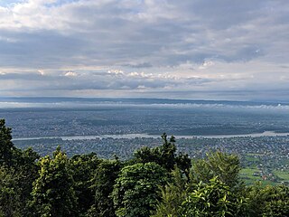
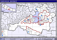
Bharatpur is a city in southern central Nepal. It is the third most populous city of Nepal after Kathmandu and Pokhara with 369,377 inhabitants in 2021. It is also the second largest metropolitan city in Nepal by area. It is the district headquarter of the Chitwan District.

<span class="mw-page-title-main">Ghorahi</span> Sub-Metropolitan City in Lumbini Province, Nepal

Ghorahi is the largest city of Nepal and largest sub-metropolitan city by area and population of Lumbini Province. The city lies in Lumbini Province in the Mid-Western part of Nepal. It is the largest city of Dang Deukhuri District of southwest Nepal. Located in the Inner Terai region, it lies 413 kilometres (257 mi) south-west of Nepal's capital Kathmandu and is one of the Counter Magnets being developed as an alternative centre of growth to help ease the migration and population explosion in the Kathmandu metropolitan area. It is the largest city of the Rapti Zone and is surrounded by the Sivalik Hills to the south and Mahabharata Range to the north.

<span class="mw-page-title-main">Kamalamai</span> Municipality in Bagmati Province, Nepal

Kamalamai is a municipality in Sindhuli District, in the Bagmati Province of central south Nepal. At the time of the 2011 Nepal census it had a population of 39,413 people in 9,304 households. The city is located in the Sindhuli Valley of central south Nepal. The historic symbol of the valley, Sindhuli Gadhi fort, is at the peak of a hill of the Mahabharata range. The city is in the plain valley made by the Kamla River. Kamalamai Municipality is the largest municipality of Nepal according to area.

<span class="mw-page-title-main">Devghat</span> Hindu Pilgrimage Site in Nepal

Devghat is one of the famous religious and cultural centers in central Nepal. At the time of the 1991 Nepal census it had a population of 5786 people living in 1132 individual households.

The Chitwan Valley is an Inner Terai valley in the south of Nepal, encompassing the districts of Makwanpur, Chitwan and Nawalpur. The valley is part of the Terai-Duar savanna and grasslands ecoregion of about 150 km (93 mi) length and 30–48 km (19–30 mi) width.

Ratnanagar is a municipality in Chitwan District of Bagmati Province in Nepal. It is the second biggest municipality after Bharatpur Metropolitan City that was formed in 1997 through the merger of the former Village Development Committees Old-Ratnanagar and Panchakanya. It is adjacent to Chitwan National Park, and serves as a gateway to the park. Agricultural products produced from Ratnanagar includes rice, maize, mustard and vegetables. This municipality is also a major place for production of poultry products and animal husbandry. Tourism is another source of income generation for the people in Ratnanagar. People are directly or indirectly dependent in tourism industry. Ratnanagar is also concerned in environment preservation so in order to preserve and protect environment, eco-friendly electric risk-shaw has also been introduced and available in different parts of this municipality. It lies on the bank of East Rapti River.

Tulsipur is a Sub-Metropolitan City in Dang District of Lumbini Province of Nepal. As per population, it is the district's second most populous city after Ghorahi. It was established in 1992 by merging the former Village development committees Tulsipur and Amritpur. In 2014, it was expanded and the Village development committees of Urahari, Tarigaun, Pawannagar and Halwar. At the time of the 2011 Nepal census it had a population of 141,528 people living in 31,243 individual households.

Birendranagar is a village development committee (VDC) in Chitwan District in the Narayani Zone of southern Nepal. At the time of the 2011 Nepal census it had a population of 14,934 people living in 3,374 individual households.

Jagatpur is a village development committee in Chitwan District, Bagmati Province, Central Development Region, Nepal. At the time of the 2011 Nepal census it had a population of 11,195 people living in 2,635 individual households.

<span class="mw-page-title-main">Kumroj</span> Place in Narayani Zone, Nepal

Kumroj is a town in Khairhani Municipality in Chitwan District in the Narayani Zone of southern Nepal. The municipality was promulgated on 18 May 2014 by merging the existing Khairahani, Kumroj and Chainpur VDCs. Kumroj is 190 km south-west of the Kathmandu valley stationed in the Rapti valley, also known as the Inner Terai or Dun. The village is situated at an altitude of 1000 ft above the sea level surrounded by two mountain ranges; the mahabharat ranges of hills on the north and the churiya siwalik hills on the south. The main point of attraction is the Chitwan National Park which today stands as a successful testimony of nature conservation in south Asia Region. Historically it was established in 1973 as the first national park of the Nepal to preserve a unique ecosystems significantly valuable to the whole world en routing this area on the world heritage site list in 1984. In the near future, this town would be one of the potential Eco-tourism village destination. Kumroj is dedicated to protect the wild animals, community forest and the Chitwan national park. Once the Southern belt of Nepal was afflicted by malaria epidemics. Tharu, the native tribe, were able to thrive even in malaria. As malaria subsided, more and more people started migrating in this place in the search of arable land, which eventually made Kumroj as a multicultural and multiethinic place. Irrigated low land has been the main stud of agriculture, permitting Rice-Rice-Pulse cropping pattern feasible.

Meghauli is a village and former Village Development Committee that is now part of Bharatpur Metropolitan City in Bagmati Province of central Nepal.

<span class="mw-page-title-main">Padampur, Nepal</span> Municipality in Bagmati, Nepal

Padampur is a village in Chitwan District in the Narayani Zone of southern Nepal. At the time of the 1991 Nepal census it had a population of 8,884 people living in 1,559 individual households. It was transferred in new location named Saguntol by Government of Nepal and completed with in 8 years i.e. from 2050 BS to 2058 BS. Previously it was at the lap of Rapati river and inside the Chitwan National Park. Flood of Rapati river in monsoon season destroy farmers crops. Wild animals also harmed their crops. Transportation, electricity, road and educational facilities were beyond people's access. It was known as one of the remote areas of the Chitwan district. In a view of agriculture, It was the best place for farmers. After the new dawn of democracy in 2046, New government was asked to shift this village for peoples safety and conservation of forest and wild animal. The cabinet of Girija Prasad Koirala was assured to shift in a convenience place soon and started the task immediately. This task was successfully done by the politician Baburam Puri of the Nepali Congress. The late Sailaja Acharya visited the people and understood their griefs and proposed to shift it next to Sagoontol near Jutpani VDC. This was a very difficult task to accomplish successfully. People from the Western Chitwan were stood against it but government took bold decision in favour of people of Padampur. Now it is about 2.5 km (1.6 mi) east to Bharatpur, district headquarters of Chitwan. Electricity, roads and transportation facility are comparatively better here. 2,800 households were there now. According to the 2001 census, the total population of the VDC was 11,336 with total households 2,137. Tharus are the dominant ethnic group with 45.89% of the total VDC population. Brahman, Kshetri, Tamang, Gurung and Newar are other castes here. Mainly banana, maize and oil are farmed here. Except ward no 1 there are deep tubewells to Irrigate farmlands. Poultry, dairy, epiculture, mushroom farming and goat keeping have great potentials here. A campus, A higher secondary school, a secondary boarding school and other 7 primary and lower secondary schools are providing education here. Health post, and Post office are too doing their best for providing services to locals. Drinking water is provided in better and modern way. Pipelines of drinking water are available within all roads (113 km) of Padampur. An NGO veterinary office is also serving and helping farmers. Since last 5 years this VDC is starting to be known as one of pocket areas of commercial banana farming of the nation. Nobody is landless here and this is the special feature here. Padampur is very attractive location for migratory view and daily people are migrating here. It is like a colonial place for settlement of people. Government has sifted it in a well planned way and that is why it is the second model VDC of Nepal. Now this village has merged in Kalika Municipality and shares 4 wards in it i.e. Kalika -9, Kalika-10, Kalika-11 and Kalika-12.

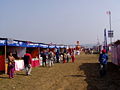
Pithuwa is one of the developed suburb area of Ratnanagar Municipality in Chitwan District in the Narayani Zone of southern Nepal. The area consists of Ward No. 13, 14 & 15. According to 2011 Nepal census survey it had a population of 12,579 people living in 2,898 individual households. Pithuwa is located West to the Kayer river [कयर खोला], East and North to Tandi and South to Khairhani Municipality. Most people of this suburbs are immigrants of Gorkha and Dhading districts. It lies in constituency region no. 2 out of five constituencies of Chitwan. The total population living here are the more immigrated from the hills, especially from Gorkha and Dhading districts. Here are also some indigenous communities, various ethnic group which co-relate their individual values and cultures like Tharus and Darais. Jana Jagriti Higher Secondary School [जन जागृती उच्च. मा. बि.], only higher secondary school of the suburbs which is the sole provider of higher education and periphery since about 5 decades. It is one of the most beautiful place of the Eastern Chitwan. It is close to the famous tourist place such as Saurah & Chitwan National Park (CNP).

<span class="mw-page-title-main">Sauraha</span> Village in Ratnanagar Municipality in Bagmati Province, Nepal

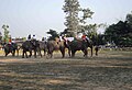
Sauraha is a village of Ratnanagar Municipality in Chitwan District and Chitwan Valley, in Bagmati Province of southern Nepal.

<span class="mw-page-title-main">Kawasoti</span> Kawasoti Municipality in Gandaki Province, Nepal

Kawasoti (Nepali: कावासोती) is a municipality in Nawalpur District, Gandaki Province, Nepal. It is 31 km (19 mi) west of Bharatpur and 85 km (53 mi) east of Butwal, approximately on the middle of Mahendra Highway. The Naryani River flows south of it, and the Mahabharat Range is north of it.

<span class="mw-page-title-main">Maula Kalika Temple</span> Hindu temple in Nepal

Maula Kalika is a famous Hindu temple of Goddess Kalika in Gaindakot town of Nawalpur district in Gandaki province of Nepal. Located on the top of the Mauladada or Maula hill on the north of Narayani River in Gaindakot, Maula Kalika temple is situated 561 metres (1,841 ft) above sea level.

Gaindakot is a municipality in Nawalpur District in the Lumbini Zone of southern Nepal. It became a municipality in May 2014 by merging the existing Mukundapur, Amarapuri, and Gaindakot VDCs. It was again expanded by merging Ratanpur VDC. It is situated on the shore of Narayani River in the lap of Maula Kalika temple. So this place has a great possibility of tourism development. At the time of the 2011 Nepal census, it had a population of 58,841 and 13,623 individual households according to 2011 Nepal census. Contributed in the article by Prashant Subedi

Shahidnagar Danda is the city center in Nawalpur District in Gandaki Province of southern Nepal. It is located in Kawasoti municipality, ward number 16. Shahidnagar Danda is locally known as Danda Bazar. It is the most highly populated areas in Kawasoti municipality after Kawasoti itself and one with a well developed infrastructure.

References

  1. Merlen, S. (ed.) (2011). An Overview of the Central Development Region. United Nations Resident & Humanitarian Coordinator's Office, Nepal
  2. "History" . Retrieved 16 May 2010.
  3. 1 2 "National Population and Housing Census 2011(National Report)" (PDF). Central Bureau of Statistics. Government of Nepal. November 2012. Archived from the original (PDF) on 18 April 2013. Retrieved 1 November 2012.
  4. "Department of Archeology team reaches Ayodhyapuri in Chitwan to conduct study on birthplace of lord Ram". Rising Nepal Daily. 16 July 2020. Retrieved 30 July 2020.
  5. Sanskrit-English Dictionary spokensanskrit.de: Sanskrit word चित्त
  6. Sanskrit-English Dictionary spokensanskrit.de: Sanskrit word वन
  7. Paudel, P. and A. Matsuoka (2008). Factors Influencing Adoption of Improved Maize Varieties in Nepal: A Case Study of Chitwan District Archived 31 October 2012 at the Wayback Machine . Australian Journal of Basic and Applied Sciences 2(4): 823–834.
  8. Gurung, K. K. (1983). Heart of the Jungle: The Wildlife of Chitwan, Nepal. André Deutsch, London.
  9. "Synergy FM 91.6 MHz".
  10. "Radio Chitwan 94.6 MHz".
  11. "Kalika FM 95.2 & 91 MHz".
  12. The Map of Potential Vegetation of Nepal – a forestry/agroecological/biodiversity classification system (PDF), Forest & Landscape Development and Environment Series 2-2005 and CFC-TIS Document Series No. 110, 2005, ISBN   87-7903-210-9 , retrieved 22 November 2013
  13. 2011 Nepal Census, Social Characteristics Tables
  14. "NEPAL: Administrative Division". www.citypopulation.de.
  15. "स्थानिय तह" (in Nepali). Ministry of Federal Affairs and General Administration. Archived from the original on 31 August 2018. Retrieved 1 September 2018.
  16. "Nepal Census 2001". Nepal's village development committees. Digital Himalaya. Archived from the original on 12 October 2008. Retrieved 19 November 2008.
  17. https://bostoncollege.edu.np/
  18. Nepali PM Prachanda Sworn In. English.cri.cn. Retrieved 3 September 2011.
  19. "Surendra PandeyCommunist Party of Nepal (Unified-Marxist- Leninist) Election Area: Chitwan-1 (Elected)". Archived from the original on 7 July 2014. Retrieved 8 August 2014.
  20. CPN-Maoist Gen Secy Thapa bereaved of father. thehimalayantimes.com. Retrieved 1 June 2014.
  21. About Shristi Shrestha – Miss Nepal Archived 4 June 2014 at the Wayback Machine . shristishrestha.org. Retrieved 1 June 2014.
  22. Regmi no more. ekantipur.com. Retrieved 10 December 2013.
  23. Book launch program. Archived 8 August 2014 at the Wayback Machine . Retrieved 11 June 2014.
  24. 'That's My Love Story' Bimochan.. Retrieved 11 June 2014.
  25. Santosh Kalwar – The Kathmandu Post.. Retrieved 17 April 2017.
  26. The Shadows, Nepal First Hard Rock Band. Retrieved 6 August 2014.
  27. Nirmal Purja – eKantipur Retrieved 25 November 2021
  28. Paudel, Ramesh Kumar. "CPN-UML recommends nominees for mayoral posts in Chitwan". My Republica. Retrieved 30 September 2022.