Colfax County is a county in the U.S. state of New Mexico. As of the 2020 census, the population was 12,387. Its county seat is Raton. It is south from the Colorado state line. This county was named for Schuyler Colfax (1823–1885), seventeenth Vice President of the United States under U.S. President Ulysses S. Grant.

Cimarron is a village in Colfax County, New Mexico, United States, which sits on the eastern slopes of the Sangre de Cristo Mountains. The population was 792 at the 2020 census, making it the fourth most populous municipality in Colfax County.

Springer is a town in Colfax County, New Mexico, United States. Its population was 1,047 at the 2010 census.

The Santa Fe Trail was a 19th-century route through central North America that connected Franklin, Missouri, with Santa Fe, New Mexico. Pioneered in 1821 by William Becknell, who departed from the Boonslick region along the Missouri River, the trail served as a vital commercial highway until 1880, when the railroad arrived in Santa Fe. Santa Fe was near the end of El Camino Real de Tierra Adentro which carried trade from Mexico City. The trail was later incorporated into parts of the National Old Trails Road and U.S. Route 66.

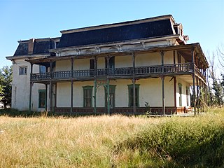
The Villa Philmonte is a large ranch home located outside of Cimarron, New Mexico, on Philmont Scout Ranch, owned by the Boy Scouts of America. It was listed on the National Register of Historic Places in 1995 as part of Villa Philmonte Historic District, which included two contributing buildings, two contributing structures, and two contributing sites. Those resources are the Villa Philmonte, an associated guesthouse, two courtyards, and a pool, pergola and pond.

Dawson is a ghost town in Colfax County, New Mexico, United States. Dawson is located approximately 17 miles northeast of Cimarron, and was the site of two separate coal mining disasters in 1913 and 1923. In 1950, the mines were closed, and by 1954 the last residents had left and the post office closed.

The St. James Hotel, located in historic downtown Cimarron, New Mexico, is a historic hotel, restaurant and saloon. Today, guests can stay at the historic hotel, in either the historic section or in a modern addition. The hotel is in the National Register of Historic Places and is part of the Cimarron Historic District.

Mogollon, also called the Mogollon Historic District, is a former mining town located in the Mogollon Mountains in Catron County, New Mexico, United States. Located east of Glenwood and Alma, it was founded in the 1880s at the bottom of Silver Creek Canyon to support the gold and silver mines in the surrounding mountains. The "Little Fannie" mine became the most important employer for the town. During the 1890s, Mogollon had a transient population of between 3,000 and 6,000 miners. Because of its isolation, it had a reputation as one of the wildest mining towns in the West. Today Mogollon is listed as Fannie Hill Mill and Company Town Historic District on the National Register of Historic Places.

Lucien Bonaparte Maxwell was a mountain man, rancher, scout, and farmer who at one point owned more than 1,700,000 acres (6,900 km2). Along with Thomas Catron and Ted Turner, Maxwell was one of the largest private landowners in United States history. In 1959, he was inducted into the Hall of Great Westerners of the National Cowboy & Western Heritage Museum.
The Maxwell Land Grant, also known as the Beaubien-Miranda Land Grant, was a 1,714,765-acre (6,939.41 km2) Mexican land grant in Colfax County, New Mexico, and part of adjoining Las Animas County, Colorado. This 1841 land grant was one of the largest contiguous private landholdings in the history of the United States. The New Mexico communities of Cimarron, Dawson, Elizabethtown, Baldy Town, Maxwell, Miami, Raton, Rayado, Springer, Ute Park and Vermejo Park came to be located within the grant, as well as numerous places that are now ghost towns.

Rayado was the first permanent settlement in Colfax County, New Mexico, United States and an important stop on the Santa Fe Trail. The name Rayado derives from the Spanish term for "streaked", perhaps in reference to the lot lines marked out by Lucien Maxwell.
Mills House is a house in Springer, New Mexico, in Colfax County, New Mexico, that was built in 1877. It was listed on the U.S. National Register of Historic Places in 1970. The locals have dubbed it the "Clegg Mansion”, after Luke and Myrtle Clegg who owned and lived in the house for several decades beginning in about 1915.

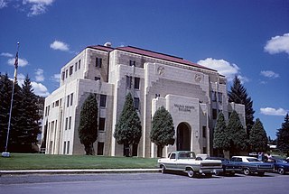
The Colfax County Courthouse in Springer, New Mexico, is a building on the National Register of Historic Places that was used as a seat of county government for Colfax County, New Mexico from 1881 until 1897. The building is located at 614 Maxwell Avenue, Springer, NM 87747, and today it houses a museum devoted to the Santa Fe Trail. The building was placed on the National Register in 1987.
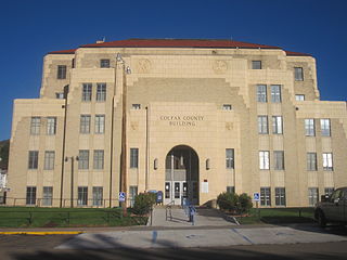
The Colfax County Courthouse is a building listed on the National Register of Historic Places. The courthouse is located at 230 North 3rd Street in Raton, New Mexico.

The Clifton House was an important overnight stage stop on the Mountain Branch of the Santa Fe Trail. It was located in Colfax County, New Mexico about six miles south of Raton, New Mexico, on the Canadian River. The site is located at mile marker 344 of U.S. Route 64, just off of exit 446 on Interstate 25.

The Eagle Nest Dam is a dam just east of the town of Eagle Nest, New Mexico on U.S. Route 64. The dam, on private property, is on the Cimarron River, and is responsible for Eagle Nest Lake.

This is a list of the National Register of Historic Places listings in Colfax County, New Mexico.
Chase Ranch in Cimarron, New Mexico was founded in 1867 by Manly and Theresa Chase. As pioneers, from Wisconsin by way of Colorado, they crossed the Raton Pass in a covered wagon and establish a new home in New Mexico. Manly Chase purchased the land from Lucien Maxwell, part of the Maxwell Land Grant. The ranch is near the Ponil Creek, a mile north of the Cimarron River, not far from the Santa Fe Trail. The Ranch included the old Kit Carson homestead. Before the arrival of pioneers, the land was populated by Apaches and Ute people. Manly provided the local Native Americans with beef, creating peaceful coexistence.

The Colfax County War was a range war that occurred from 1873 to 1888 between settlers and the new owners of the Maxwell Land Grant in Colfax County, in the U.S. state of New Mexico. The war started when the new landowners tried to remove the local settlers from the land they had just bought. The locals refused to leave, as they had settled much of their livelihood in the grant, which resulted in conflict and violence in 1875.

Baldy Town, New Mexico is a former mining town in the Baldy Mining District in Colfax County, New Mexico. Baldy Town was established in 1868, to service mining prospects on the East side of Baldy Mountain, notably the Aztec Mine. After Baldy Town's initial high profit boom from 1868 to 1870, Baldy Town suffered a series of booms and busts as investors and prospectors searched for profitable lodes. The town was originally a conglomerate of miner's homes and services in Ute Meadow. Then in 1886, Baldy Town's core was moved to a strip of services just above the Aztec Mill. The new town grew to accommodate hundreds of residents with a store, stables, saloons, boarding houses, a church, small school, and post office. In 1895, at the height of its population, Baldy Town was home to around 1,000 residents. Multiple ambitious and extensive expeditions were made from 1870 to 1936 to discover additional gold veins, but only a select few found substantial lodes. By 1941, Baldy Town had been deserted and a majority of its infrastructure sold. In 1963, the eastern half of Baldy Mountain, including former Baldy Town, was donated to the Boy Scouts of America by Norton Clapp. Today, Baldy Town operates as a staffed camp at Philmont Scout Ranch providing a living history program regarding mining as well as logistical support like food resupply for hikers


