Current listings
Properties listed on the New Mexico State Register of Cultural Properties: [2]
- San Miguel, Church of
- Route 66 & Nat'l Old Trails Rd Hist Dist at La Bajada
- Fort McRae (LA 4983)
- Carrie Tingley Hospital Historic District
- Thomas Branigan Memorial Library
- Couse, Eanger Irving, House and Studio and Sharp, Joseph Henry, Studios
- Ozark Trails Marker at Lake Arthur
- St. Joseph Apache Mission Church
- New Mexico Madonna of the Trail
- Agua Fria Schoolhouse Site (LA 2)
- El Camino Real de Tierra Adentro, N Arroyo Alamillo Sect
- Oliver Lee Dog Canyon Ranch
- Raton Pass Scenic Highway
- Gallup Commercial Historic District
- Paul Laurence Dunbar Elementary School
- Tortugas Pueblo Fiesta of Our Lady of Guadalupe
- Roswell Artist-in-Residence Compound
- Lincoln Jackson School
- Casa del Gavilan
- St. John's Cathedral
- Main Library, Albuquerque
- John Gaw Meem Architects Office
- Georgia O'Keeffe Ghost Ranch House
- Burnt Corn Archaeological District
- Hyde Memorial State Park
Not in the boundaries of New Mexico
Nominated due to connections with New Mexico people and institutions,[ which? ] not because it is a territorial claim of New Mexico.
| [3] | Name | Image | Location | Description |
|---|---|---|---|---|
| 1946 | Tranquility Base |  | Mare Tranquillitatis, Moon 00°41′15″N23°26′00″E / 0.68750°N 23.43333°E | Scientific and other facilities used during the Apollo 11 mission |
Multiple counties
| [3] | Name | Image | Location | Description |
|---|---|---|---|---|
| 363 | High Road to Taos |  | Santa Fe to Taos 35°53′49″N106°1′12″W / 35.89694°N 106.02000°W | Scenic route passing through the Sangre de Cristo Mountains |
| 1952 | Camino Real in New Mexico, AD 1598-1881 | 100px | Multiple | MPDF |
| 1953 | Camino Real - La Bajada Mesa Section | 100px | Santa Fe | |
| 1954 | Camino Real - Canon de Las Bocas Section | 100px | Santa Fe | |
| 1955 | Camino Real - Los Alamitas Section | 100px | Santa Fe | |
| 1956 | Camino Real - Qualacu Pueblo | 100px | Socorro | |
| 1957 | Camino Real - San Pasqual Pueblo | 100px | Socorro | |
| 1958 | Camino Real - Jornada Lakes Section | 100px | Sierra | |
| 1959 | Camino Real - Yost Draw Section | 100px | Sierra | |
| 1960 | Camino Real - Point of Rocks Section | 100px | Sierra | |
| 1961 | Camino Real - Rincon Arroyo - Perillo Section | 100px | Dona Ana | |
| 1962 | Camino Real - San Diego South Section | 100px | Dona Ana | |
| 1963 | Camino Real - San Diego North-South Section | 100px | Dona Ana |
Bernalillo County
| [3] | Name | Image | Location | Description | |
|---|---|---|---|---|---|
| 39 | San Felipe de Neri Church |  | Old Town Plaza, Albuquerque 35°5′48″N106°40′11″W / 35.09667°N 106.66972°W | ||
| 277 | Occidental Life Building | 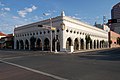 | 119 3rd Street SW, Albuquerque | ||
| 336 | Hodgin Hall | 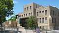 | University of New Mexico main campus, Albuquerque 35°04′54″N106°37′31″W / 35.08169°N 106.62535°W | ||
| 366 | Atchison, Topeka & Santa Fe Railway Locomotive 2926 | 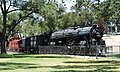 | |||
| 380 | Salvador Armijo House |  | 618 Rio Grande Blvd. NW, Albuquerque 35°5′58″N106°40′10″W / 35.09944°N 106.66944°W | ||
| 383 | First Methodist Episcopal Church |  | 315 Coal Avenue SW, Albuquerque | ||
| 388 | Scholes Hall |  | University of New Mexico main campus, Albuquerque 35°05′07″N106°37′25″W / 35.08532°N 106.62357°W | ||
| 397 | Southwestern Brewery and Ice Company |  | 601 Commercial St. NE, Albuquerque, New Mexico 35°5′20″N106°38′44″W / 35.08889°N 106.64556°W | Built in 1899, the Southwestern Brewery and Ice Company building is one of the few surviving 19th-century commercial buildings in downtown Albuquerque. | |
| 453 | KiMo Theater |  | 423 Central Avenue NW, Albuquerque | ||
| 480 | Gutiérrez Hubbell House |  | 6029 Isleta Boulevard SW 34°59′20″N106°41′47″W / 34.98889°N 106.69639°W | ||
| 508 | Old Albuquerque High School |  | Central Avenue and Broadway Boulevard, Albuquerque | ||
| 588 | Rosenwald Building |  | 320 Central Avenue SW, Albuquerque | ||
| 660 | First National Bank Building |  | 217-233 Central Avenue NW, Albuquerque | ||
| 700 | Federal Building and United States Courthouse |  | 421 Gold Avenue SW, Albuquerque | ||
| 704 | Kelvinator House |  | 324 Hermosa Drive SE, Albuquerque | ||
| 737 | Harwood School | 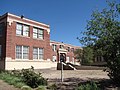 | <114 7th Street NW, Albuquerque | ||
| 784 | Skinner Building | 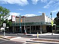 | 722 Central Avenue SW, Albuquerque | ||
| 787 | New Mexico-Arizona Wool Warehouse |  | 520 1st Street NW, Albuquerque | ||
| 880 | Werner-Gilchrist House | 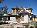 | 202 Cornell Drive SE, Albuquerque | Demolished November 2011 | |
| 991 | Nob Hill Business Center |  | 3500 Central Avenue SE, Albuquerque | ||
| 992 | Old Hilton Hotel | 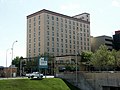 | 125 2nd Street NW, Albuquerque | ||
| 1170 | Sunshine Building |  | 120 Central Avenue SW, Albuquerque 35°5′3″N106°38′56″W / 35.08417°N 106.64889°W | ||
| 1171 | Solar Building |  | <213 Truman Street NE, Albuquerque | ||
| 1412 | Estufa |  | University of New Mexico main campus, Albuquerque 35°05′02″N106°37′33″W / 35.08391°N 106.6259°W | ||
| 1453 | Carlisle Gymnasium |  | University of New Mexico main campus, Albuquerque 35°05′01″N106°37′22″W / 35.08363°N 106.62272°W | ||
| 1455 | Sara Raynolds Hall | | University of New Mexico main campus, Albuquerque | ||
| 1568 | Jones Motor Company |  | 3222 Central Avenue SE, Albuquerque | ||
| 1644 | Coronado School | | 601 4th Street NW, Albuquerque | ||
| 1659 | Ernie Pyle House/Library |  | 800 Girard Boulevard SE, Albuquerque | ||
| 1693 | Simms Building |  | 400 Gold Avenue SW, Albuquerque | ||
| 1837 | De Anza Motor Lodge |  | 4301 Central Avenue NE, Albuquerque | Partially demolished 2017-18 | |
| 1853 | Southern Union Gas Company Building |  | 723 Silver Avenue SW, Albuquerque | ||
| 2026 | Zimmerman Library | | University of New Mexico main campus | Meem MPDF |
Catron County
| [3] | Name | Image | Location | Description |
|---|---|---|---|---|
| 424 | Ake Site |
Colfax County
| [3] | Name | Image | Location | Description | |
|---|---|---|---|---|---|
| 28 | St. James Hotel | | 617 S Collison Ave, Cimarron | Colfax | Historic hotel, restaurant and bar built in 1872 |
| 1611 | Villa Philmonte Historic District |  | Philmont Scout Ranch, 401 NM Highway 21, Cimarron | Built 1926–27 as the vacation home of Waite Phillips and his family. Gifted to the Boy Scouts of America in 1941. |
Doña Ana County
| [3] | Name | Image | Location | Description |
|---|---|---|---|---|
| 36 | Fort Fillmore | 32°15′28″N106°44′36″W / 32.25778°N 106.74333°W |
Luna County
| [3] | Name | Image | Location | Description |
|---|---|---|---|---|
| 35 | Fort Cummings | 32°27′56″N107°38′45″W / 32.46556°N 107.64583°W | ||
| 584 | Deming Armory |  | 301 South Silver Avenue, Deming 32°16′0.02″N107°45′24.39″W / 32.2666722°N 107.7567750°W | Built for the National Guard in 1915–16, it was the first armory to be built after New Mexico became a state in 1912, and was used during Pancho Villa's raid on Columbus |
Mora County
| [3] | Name | Image | Location | Description |
|---|---|---|---|---|
| 32 | Wagon Mound |  | 36°0′26″N104°42′26″W / 36.00722°N 104.70722°W | Landmark on the Santa Fe Trail |
| 33 | Watrous/La Junta |  | 35°48′3″N105°0′5″W / 35.80083°N 105.00139°W | Settlement at the junction of the Mountain and Cimarron Cutoff routes of the Santa Fe Trail |
San Juan County
| [3] | Name | Image | Location | Description |
|---|---|---|---|---|
| 21 | Salmon Ruins |  | 36°42′4″N108°1′38″W / 36.70111°N 108.02722°W | Chacoan site located in northwest New Mexico |
| style="background: #FAF284" | Pictured Cliffs Archeological Site | 100px | restricted coordinates |
Santa Fe County
| [3] | Name | Image | Location | Description |
|---|---|---|---|---|
| 83 | Davey, Randall, House |  | Top of Canyon Road, Santa Fe 35°41′23″N105°53′17″W / 35.68972°N 105.88806°W | |
| 2074 | El Rancho de las Golondrinas |  | 334 Los Pinos Road | District |
| 1901 | Arroyo Hondo Pueblo | 100px | Arroyo Hondo |
Socorro County
| [3] | Name | Image | Location | Description |
|---|---|---|---|---|
| 30 | Trinity Site | 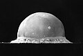 | 33°40′38″N106°28′31″W / 33.67722°N 106.47528°W | Site of the first nuclear weapons test |
Taos County
| [3] | Name | Image | Location | Description |
|---|---|---|---|---|
| 503 | Ojo Caliente Mineral Springs Barn | 500 yards north of West term of State Road 414 | ||
| 802 | Taos Inn |  | Paseo Del Pueblo Norte, Taos | |
| 1841 | D. H. Lawrence Ranch Historic District |  | near San Cristobal 36°34′55″N105°35′37″W / 36.58194°N 105.59361°W |
Torrance County
| [3] | Name | Image | Location | Description |
|---|---|---|---|---|
| 1 | Abo Mission Ruin NR & NHL |  | 34°26′56″N106°22′17″W / 34.44889°N 106.37139°W | Tanoan site located in central New Mexico |
