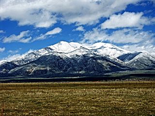
Taos County is a county in the U.S. state of New Mexico. As of the 2020 census, the population was 34,489. Its county seat is Taos. The county was formed in 1852 as one of the original nine counties in New Mexico Territory.

South Valley is a census-designated place (CDP) and town in Bernalillo County, New Mexico, United States. The population was 40,976 at the 2010 Census. It is part of the Albuquerque Metropolitan Statistical Area. The U.S. Postal Service uses "Albuquerque" for all South Valley addresses.
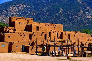
Taos Pueblo is a census-designated place (CDP) in Taos County, New Mexico, just north of Taos. The population was 1,264 at the 2000 census.

Vadito is a census-designated place (CDP) in southern Taos County, New Mexico, United States. It is on the scenic High Road to Taos. The population was 270 at the 2010 census.

Hernandez is an unincorporated community and census-designated place in Rio Arriba County, New Mexico, United States. Hernandez is approximately 5 miles (8.0 km) northwest of Española on highway US 84 / US 285.
Canjilon is a census-designated place in Rio Arriba County, New Mexico, United States. Its population was 256 as of the 2010 census. Canjilon has a post office with ZIP code 87515. The community is located along New Mexico State Road 115. Canjilon was first settled in 1870, and by 1880, 35 families lived here.
Blanco is a census-designated place in San Juan County, New Mexico, United States. Its population was 388 as of the 2010 census. Blanco has a post office with ZIP code 87412, which opened on March 6, 1901. U.S. Route 64 passes through the community.
La Plata is a census-designated place in San Juan County, New Mexico, United States. Its population was 612 as of the 2010 census. La Plata has a post office with ZIP code 87418. The community is located at the junction of state roads 170 and 574.
Navajo Dam is a census-designated place in San Juan County, New Mexico, United States. Its population was 253 as of the 2020 census. Navajo Dam has a post office with ZIP code 87419. The community is located in the vicinity of Navajo Dam.
Monument is a census-designated place and unincorporated community in Lea County, New Mexico, United States. Its population was 206 as of the 2010 census. Monument has a post office with ZIP code 88265. State routes 8 and 322 intersect in the community. It was the first inhabited community in Lea County and was named after nearby Monument Spring. Jim Cook established the post office and a general store.
Capulin is a census-designated place and unincorporated community in Union County, New Mexico, United States. Its population was 66 as of the 2010 census. Capulin had a post office until August 13, 2011; it still has its own ZIP code, 88414. U.S. routes 64 and 87 pass through the community. Capulin Volcano National Monument is located 5 kilometres (3.1 mi) north of Capulin. The town was named after the volcano by Hispanic settlers after the Civil War. It was known as Dedman from 1909 to 1922, after railroad superintendent E.J. Dedman.

Costilla is a census-designated place in Taos County, New Mexico, United States. Its population was 205 as of the 2010 census. Costilla has a post office with ZIP code 87524. State roads 196 and 522 intersect in the community.

La Madera is a census-designated place in Rio Arriba County, New Mexico, United States. Its population was 154 as of the 2010 census. La Madera has a post office with ZIP Code 87539. state routes 111 and 519 intersect in the community.
Los Ojos is a census-designated place (CDP) in Rio Arriba County, New Mexico, United States. Its population was 125 as of the 2010 census. Los Ojos has a post office with ZIP code 87551, which opened on February 7, 1877. The community is located near U.S. routes 64 and 84.
San Jose is a census-designated place in San Miguel County, New Mexico, United States. Its population was 137 as of the 2010 census. San Jose has a post office, with ZIP code 87565. Exit 319 of Interstate 25 serves the community.
Anton Chico, or Anton Chico Abajo or Anton Chico de Abajo, is a census-designated place in Guadalupe County, New Mexico, United States. Its population was 188 as of the 2010 census, of which 167 were Hispanic in origin. Anton Chico has a post office with ZIP code 87711. New Mexico State Road 386 passes through the community. Anton Chico is listed in the National Register of Historic Places.
Lemitar is a census-designated place in Socorro County, New Mexico, United States. Its population was 330 as of the 2010 census. Lemitar has a post office with ZIP code 87823. Exit 156 on Interstate 25 serves the community.
Garfield is a census-designated place in Doña Ana County, New Mexico, United States. Its population was 137 at the time of the 2010 census. Garfield has a post office with ZIP code 87936, which opened on September 19, 1896. The community is located on New Mexico State Road 187 south of Exit 51 of Interstate 25.
Medanales is an unincorporated community located in Rio Arriba County, New Mexico, United States. The community is located on the Chama River near U.S. Route 84, 14 miles (23 km) north-northwest of Española. Medanales has a post office with ZIP code 87548, which opened on March 10, 1945.
Chili is an unincorporated community and census-designated place in Rio Arriba County, New Mexico. Its population was 654 as of the 2010 census. U.S. Route 84 passes through the community. The name comes from a station of the D&RG railroad that was known locally as the "Chili Line."


