

Tres Piedras (Spanish: three rocks) [1] is an unincorporated community in Taos County, northern New Mexico, United States, adjacent to Carson National Forest.
Tres Piedras (Spanish: three rocks) [1] is an unincorporated community in Taos County, northern New Mexico, United States, adjacent to Carson National Forest.
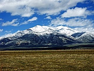
Tres Piedras is located approximately 30 miles northwest of Taos, and west of the Rio Grande on U.S. Route 64. At approximately 8,000 feet (2,400 m) in altitude, it is located within the southern portion of the San Juan Range of the Rocky Mountains. Tres Piedras is on the western edge of a sagebrush plain, with ponderosa pines growing throughout the village. [2] The village is adjacent to the Carson National Forest. [3] The ZIP Code for Tres Piedras is 87577. [4]
| Climate data for Tres Piedras, New Mexico, 1991–2020 normals, 1905-2020 extremes: 8139ft (2481m) | |||||||||||||
|---|---|---|---|---|---|---|---|---|---|---|---|---|---|
| Month | Jan | Feb | Mar | Apr | May | Jun | Jul | Aug | Sep | Oct | Nov | Dec | Year |
| Record high °F (°C) | 61 (16) | 67 (19) | 71 (22) | 80 (27) | 87 (31) | 95 (35) | 93 (34) | 92 (33) | 89 (32) | 89 (32) | 74 (23) | 64 (18) | 95 (35) |
| Mean maximum °F (°C) | 49.7 (9.8) | 52.3 (11.3) | 62.2 (16.8) | 69.1 (20.6) | 79.6 (26.4) | 85.1 (29.5) | 88.3 (31.3) | 84.5 (29.2) | 80.0 (26.7) | 73.2 (22.9) | 61.3 (16.3) | 51.9 (11.1) | 86.6 (30.3) |
| Mean daily maximum °F (°C) | 37.5 (3.1) | 40.8 (4.9) | 50.3 (10.2) | 58.6 (14.8) | 66.1 (18.9) | 79.0 (26.1) | 81.3 (27.4) | 77.9 (25.5) | 72.3 (22.4) | 61.5 (16.4) | 47.7 (8.7) | 38.5 (3.6) | 59.3 (15.2) |
| Daily mean °F (°C) | 22.7 (−5.2) | 26.5 (−3.1) | 34.9 (1.6) | 42.1 (5.6) | 49.6 (9.8) | 60.9 (16.1) | 64.8 (18.2) | 62.7 (17.1) | 56.3 (13.5) | 45.1 (7.3) | 32.7 (0.4) | 24.2 (−4.3) | 43.5 (6.4) |
| Mean daily minimum °F (°C) | 8.0 (−13.3) | 12.2 (−11.0) | 19.6 (−6.9) | 25.6 (−3.6) | 33.2 (0.7) | 42.7 (5.9) | 48.2 (9.0) | 47.4 (8.6) | 40.4 (4.7) | 28.8 (−1.8) | 17.6 (−8.0) | 9.9 (−12.3) | 27.8 (−2.3) |
| Mean minimum °F (°C) | −7.6 (−22.0) | −4.9 (−20.5) | 1.7 (−16.8) | 13.0 (−10.6) | 23.1 (−4.9) | 31.0 (−0.6) | 40.0 (4.4) | 40.4 (4.7) | 30.9 (−0.6) | 12.7 (−10.7) | −0.7 (−18.2) | −6.1 (−21.2) | −11.2 (−24.0) |
| Record low °F (°C) | −35 (−37) | −35 (−37) | −23 (−31) | −4 (−20) | 11 (−12) | 16 (−9) | 25 (−4) | 27 (−3) | 15 (−9) | −5 (−21) | −22 (−30) | −37 (−38) | −37 (−38) |
| Average precipitation inches (mm) | 0.92 (23) | 0.70 (18) | 1.05 (27) | 0.70 (18) | 0.97 (25) | 1.23 (31) | 2.20 (56) | 2.99 (76) | 1.24 (31) | 1.16 (29) | 0.85 (22) | 0.82 (21) | 14.83 (377) |
| Average snowfall inches (cm) | 8.8 (22) | 10.1 (26) | 3.4 (8.6) | 1.0 (2.5) | 0.1 (0.25) | 0.0 (0.0) | 0.0 (0.0) | 0.0 (0.0) | 0.0 (0.0) | 0.8 (2.0) | 3.3 (8.4) | 11.4 (29) | 38.9 (98.75) |
| Source 1: NOAA (1981-2010 precipitation & snowfall) [5] [6] | |||||||||||||
| Source 2: XMACIS2 (records & monthly max/mins) [7] | |||||||||||||
The earliest maps, from the 1770s, show the name Piedras de los Carneros, or Rocks of the Sheep, possibly denoting a population of Bighorn Sheep. While the mountains and valleys east of the Rio Grande were colonized by Spanish agriculturalists & pastoralists some 200 years earlier, the Taos Plateau and Tusas Mountains were used by the nomadic peoples: Ute, Comanche, Kiowa and Jicarilla Apache, and so weren't utilized by the pobladores or Hispano colonists until well after the Mexican-American War (1846–1848) and subsequent presence of the U. S. Army.
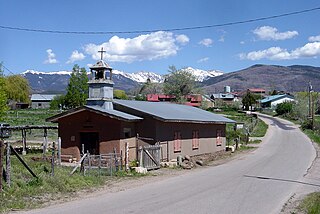
The village, named for three outcroppings of granite, was settled in 1879 and became a small ranching and timber village. [2] Homesteaders, sawmills, small scale dry farming and mining activity slowly augmented the population through the late nineteenth and early twentieth centuries. Some Mormon pioneers from the San Luis valley to the north also made their way to Tres Piedras and established themselves.
By the turn of the twentieth century several villages were established in the area: Hopewell, 20 miles to the west, a gold-mining town; Las Tusas, nine miles west, a largely Hispanic farming community spread along the river valley of the same name, and No Agua (no water), 9 miles north on the railway line. All three of these places are virtually uninhabited today. Between 1880 and 1941 Tres Piedras was a railroad stop on the narrow gauge Chili Line railroad that operated between Antonito, Colorado and Santa Fe, New Mexico. The village still has the old railroad water tower. [3]
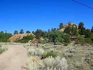
It is a granite climbing area, one of two west of the Rio Grande in New Mexico. [1]
Taos County is a county in the U.S. state of New Mexico. As of the 2020 census, the population was 34,489. Its county seat is Taos. The county was formed in 1852 as one of the original nine counties in New Mexico Territory.

Antonito is a Statutory Town located in Conejos County, Colorado, United States. The town population was 647 at the 2020 United States Census.

Questa is a village in Taos County, New Mexico, United States. The population was 1,770 at the 2010 census. The village has trails into the Rio Grande Gorge, trout fishing, and mountain lakes with trails that access the Sangre de Cristo Mountains that overlook the area. Questa is on the Enchanted Circle Scenic Byway, near the confluence of the Rio Grande and the Red River. The "Gateway to the Rio Grande del Norte Monument", its visitors can drive to an overlook of the Red River meeting the Rio Grande in the depth of the gorge. The Carson National Forest parallels Questa to the east. The Columbine Hondo Wilderness and Latir Peak Wildness are in the Carson National Forest close to Questa.

The Sangre de Cristo Mountains are the southernmost subrange of the Rocky Mountains. They are located in southern Colorado and northern New Mexico in the United States. The mountains run from Poncha Pass in South-Central Colorado, trending southeast and south, ending at Glorieta Pass, southeast of Santa Fe, New Mexico. The mountains contain a number of fourteen thousand foot peaks in the Colorado portion, as well as several peaks in New Mexico which are over thirteen thousand feet.

The Rio Grande Gorge is a geological feature in northern New Mexico where the watercourse of the Rio Grande follows a tectonic chasm. Beginning near the Colorado border, the approximately 50-mile (80 km) gorge runs from northwest to southwest of Taos, New Mexico, through the basalt flows of the Taos Plateau volcanic field. The gorge depth is 800 feet (240 m) just south of the Rio Grande Gorge Bridge, which spans the gorge 10 miles (16 km) northwest of Taos.

Carson National Forest is a national forest in northern New Mexico, United States. It encompasses 6,070 square kilometers and is administered by the United States Forest Service. The Forest Service's "mixed use" policy allows for its use for recreation, grazing, and resource extraction.

The Brazos Mountains is a range in far northern Rio Arriba County, in northern New Mexico in the southwestern United States. The range is part of the Tusas Mountains, which extended slightly into Colorado. A high crest runs from the border with Colorado for over 20 miles (32 km) in a south-southeasterly direction. The high point of the range at 11,405 feet (3,476 m) is on Grouse Mesa, at the Brazos Benchmark. Two miles (3 km) to the southeast is the more distinctive Brazos Peak, at 11,288 feet.

Embudo is an unincorporated community in Rio Arriba County, New Mexico, United States. The community runs along both sides of the Rio Grande on New Mexico State Road 68, beginning at Embudo Station located 2.9 miles (4.7 km) south of the intersection of New Mexico State Road 75, near where the Embudo Creek flows into the Rio Grande, encompassing the communities of La Bolsa and Rinconada and ending at the Taos County Line.
The 56-mile (90 km) High Road to Taos is a scenic, winding road through the Sangre de Cristo Mountains between Santa Fe and Taos.. It winds through high desert, mountains, forests, small farms, and tiny Spanish land grant villages and Pueblo Indian villages. Scattered along the way are the galleries and studios of traditional artisans and artists drawn by the natural beauty. It has been recognized by the state of New Mexico as an official scenic byway.

San Antonio Mountain is a free-standing volcanic peak in Rio Arriba County, New Mexico. With an elevation of 10,908 feet, San Antonio Mountain is the highest peak within the Taos Plateau volcanic field, the largest volcanic field within the Rio Grande Rift valley.

La Madera is a census-designated place in Rio Arriba County, New Mexico, United States. Its population was 154 as of the 2010 census. La Madera has a post office with ZIP Code 87539.

The Enchanted Circle Scenic Byway is a New Mexico Scenic Byway and National Forest Scenic Byway located in Northern New Mexico. It begins and ends in Taos, New Mexico.
John Dunn Bridge is located in Arroyo Hondo in north-central New Mexico. It crosses the Rio Grande near the confluence of the Rio Hondo. It was built in 1908 by John Dunn who transported travelers and mail into Taos and housed travelers overnight at his hotel near the bridge. It was sold to the Territory of New Mexico in 1912, and at that time the toll bridge was made a free bridge to travelers. Recreational opportunities on the rivers include fishing, kayaking, and whitewater rafting. It is near the Black Rock Hot Springs.

Wild Rivers Recreation Area is located in north central New Mexico within the Rio Grande del Norte National Monument. Two rivers that run through the park, the Rio Grande and Red River are National Wild and Scenic Rivers. NM 378 that traverses the recreation area is designated a New Mexico Scenic Byway. Recreational opportunities include whitewater rafting, hiking, biking, fishing and camping.
Bobcat Pass is a mountain pass located in Taos County, New Mexico on the Enchanted Circle Scenic Byway.
Palo Flechado Pass, also called Taos Pass and Old Taos Pass, is a mountain pass located in Taos County, New Mexico, United States on the Enchanted Circle Scenic Byway.

The Tusas Mountains are a mountain range in northern New Mexico, extending slightly into southern Colorado. They are considered the southeasternmost part of the San Juan Mountains. Grouse Mesa, 11,407 feet (3,477 m), is the highest peak in the range. The mountains are located to the west of Taos and northwest of Santa Fe. The Tusas Mountains are a wide region of upland mesas and gently sloping mountains, dissected in places by deep canyons.

Manby Hot Springs, also known as Stagecoach Hot Springs are thermal springs located near the town of Arroyo Hondo, New Mexico. The springs discharge into three rock pools with sandy bottoms located near the ruins of an old bathhouse and a historical stagecoach stop.
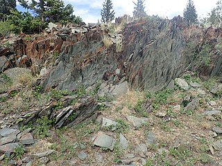
The Moppin Complex is a Precambrian geologic complex found in the Tusas Mountains of northern New Mexico. It has not been directly dated, but is thought to be Statherian based on a minimum age of 1.755 Gya from radiometric dating of magmatic intrusions.
The Tres Piedras Orthogneiss is a pluton in northern New Mexico. It has a U-Pb radiometric age of 1693 Mya, placing it in the Statherian period.
36°38′56.04″N105°58′2.91″W / 36.6489000°N 105.9674750°W
Municipalities and communities of Taos County, New Mexico, United States | ||
|---|---|---|
| Towns |  | |
| Villages | ||
| CDPs | ||
| Other communities | ||
| Ghost towns | ||
| Indian reservation | ||
| Footnotes | ‡This populated place also has portions in an adjacent county or counties | |