Taos Pueblo, New Mexico

Last updated

Taos Pueblo, New Mexico
CDP
Taos Pueblo2.jpg
Taos Pueblo
Taos County New Mexico Incorporated and Unincorporated areas Taos Pueblo Highlighted.svg
Location of Taos Pueblo, New Mexico
Usa edcp location map.svg
Red pog.svg
Taos Pueblo, New Mexico
Location in the United States
Coordinates: 36°26′55″N105°33′14″W / 36.44861°N 105.55389°W / 36.44861; -105.55389
Country United States
State New Mexico
County Taos
Area
[1]
  Total15.60 sq mi (40.40 km2)
  Land15.60 sq mi (40.40 km2)
  Water0.00 sq mi (0.00 km2)
Elevation
7,119 ft (2,170 m)
Population
 (2020) [2]
  Total1,196
  Density76.67/sq mi (29.60/km2)
Time zone UTC−07:00 (Mountain (MST))
  Summer (DST) UTC−06:00 (MDT)
ZIP Code
87571
Area code 575
FIPS code 35-76410
GNIS feature ID0928824
Website www.taospueblo.com

Taos Pueblo is a census-designated place (CDP) in Taos County, New Mexico, United States, just north of Taos. The population was 1,264 at the 2000 census.

Contents

Geography

Taos Pueblo is located at 36°26′55″N105°33′14″W / 36.44861°N 105.55389°W / 36.44861; -105.55389 (36.448735, -105.553979). [3] Rio Pueblo de Taos passes through Taos Pueblo.

According to the United States Census Bureau, the CDP has a total area of 15.6 square miles (40.5 km2), all land.

Culture and history

Taos Pueblo is the only living Native American community designated both a World Heritage Site by UNESCO and a National Historic Landmark.

The multi-storied Taos Pueblo adobe buildings have been continuously inhabited for over 1000 years.

Taos Pueblo Church Taos Pueblo Church 3.jpg
Taos Pueblo Church

Demographics

Historical population
CensusPop.Note
2020 1,196
U.S. Decennial Census [4] [2]

As of the census [5] of 2000, there were 1,264 people, 441 households, and 316 families residing in the CDP. The population density was 80.9 inhabitants per square mile (31.2/km2). There were 682 housing units at an average density of 43.6 per square mile (16.8/km2).

The racial makeup of the CDP was 2.93% White, 95.02% Native American, 0.40% Pacific Islander, 0.32% from other races, and 1.34% from two or more races. Hispanic or Latino people of any race were 4.11% of the population.

Age

There were 441 households, out of which 29.5% had children under the age of 18 living with them, 39.0% were married couples living together, 20.6% had a female householder with no husband present, and 28.3% were non-families. 25.6% of all households were made up of individuals, and 9.3% had someone living alone who was 65 years of age or older. The average household size was 2.87 and the average family size was 3.39.

In the CDP, the population was spread out, with 26.1% under the age of 18, 8.5% from 18 to 24, 28.8% from 25 to 44, 22.1% from 45 to 64, and 14.5% who were 65 years of age or older. The median age was 36 years. For every 100 females, there were 102.6 males. For every 100 females age 18 and over, there were 103.0 males.

Income

The median income for a household in the CDP was $20,682, and the median income for a family was $23,867. Males had a median income of $19,861 versus $18,333 for females. The per capita income for the CDP was $10,002. About 27.4% of families and 31.6% of the population were below the poverty line, including 36.3% of those under age 18 and 38.0% of those age 65 or over.


Taos Pueblo, NM.jpg
Landscape of Taos Pueblo, Rio Pueblo de Taos, and the Sangre de Cristo Mountains
I Taos Pueblo, NM, USA (2).jpg
Taos Pueblo Cemetery

Education

It is within Taos Municipal Schools, [6] which operates Taos High School.

The Bureau of Indian Education-operated Taos Day School is in Taos Pueblo. [7]

See also

Related Research Articles

<span class="mw-page-title-main">Taos County, New Mexico</span> County in New Mexico, United States

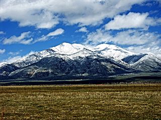
Taos County is a county in the U.S. state of New Mexico. As of the 2020 census, the population was 34,489. Its county seat is Taos. The county was formed in 1852 as one of the original nine counties in New Mexico Territory.

<span class="mw-page-title-main">Vine Hill, California</span> Census-designated place in California, United States

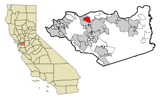
Vine Hill is a census-designated place (CDP) in Contra Costa County, California, United States. The population was 3,761 at the 2010 census. It is located 2.25 miles (3.6 km) east of downtown Martinez.

<span class="mw-page-title-main">Gandy, Florida</span> Place in Florida, United States

Gandy is an unincorporated community and former census-designated place (CDP) in Pinellas County, Florida, United States. The population was 2,031 at the 2000 census. It is named after George Gandy and the Gandy Bridge which connects the area to Tampa across Old Tampa Bay.

<span class="mw-page-title-main">Moapa Valley, Nevada</span> Unincorporated town in the State of Nevada, United States

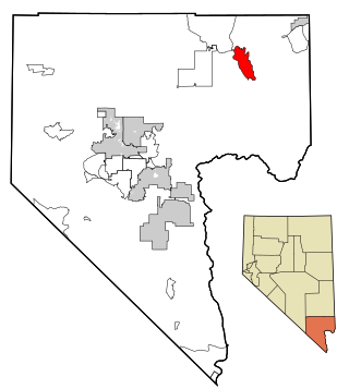
Moapa Valley is an unincorporated town in Clark County, Nevada, United States. As of the 2010 census, it had a population of 6,924. The valley in which the community lies, also named Moapa Valley, is about 40 miles (64 km) long and lies roughly northwest to southeast.

<span class="mw-page-title-main">Isleta Village Proper, New Mexico</span> Census-designated place in New Mexico, United States

Isleta Village Proper is a census-designated place (CDP) in Bernalillo County, New Mexico, United States. The population was 491 at the 2010 census. It is part of the Albuquerque Metropolitan Statistical Area.

<span class="mw-page-title-main">Laguna, New Mexico</span> Census-designated place in New Mexico, United States

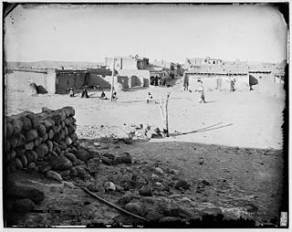
Laguna is a census-designated place (CDP) on the Laguna Pueblo in Cibola County, New Mexico, United States. The population was 1,241 at the 2010 census. It is located approximately 47 miles west of Albuquerque.

<span class="mw-page-title-main">Pueblo Pintado, New Mexico</span> CDP in New Mexico, United States

Pueblo Pintado is a census-designated place (CDP) in McKinley County, New Mexico, United States. The population was 247 at the 2000 census.

<span class="mw-page-title-main">Zia Pueblo, New Mexico</span> CDP in New Mexico, United States

Zia Pueblo is a census-designated place (CDP) in Sandoval County, New Mexico, United States. The population was 646 at the 2000 census, with 310 males and 336 females. The pueblo after which the CDP is named is included within the CDP; it is listed on the National Register of Historic Places.

<span class="mw-page-title-main">Rio Chiquito, New Mexico</span> CDP in New Mexico, United States

Rio Chiquito is a census-designated place in Santa Fe County, New Mexico, United States. It is part of the Santa Fe, New Mexico Metropolitan Statistical Area. The population was 103 at the 2000 census.

<span class="mw-page-title-main">Santa Cruz, New Mexico</span> CDP in New Mexico, United States

Santa Cruz, historically known as Santa Cruz de la Cañada, is a census-designated place (CDP) in Santa Fe County, New Mexico, United States. It is part of the Santa Fe, New Mexico Metropolitan Statistical Area. The population was 423 at the 2000 census.

<span class="mw-page-title-main">Tesuque, New Mexico</span> CDP in New Mexico, United States

Tesuque is a census-designated place (CDP) in Santa Fe County, New Mexico, United States. It is part of the Santa Fe, New Mexico, Metropolitan Statistical Area. The population was 1,094 at the 2020 census. The area is separate from but located near Tesuque Pueblo, a member of the Eight Northern Pueblos, and the Pueblo people are from the Tewa ethnic group of Native Americans who speak the Tewa language. The pueblo was listed as a historic district on the National Register of Historic Places in 1973.

<span class="mw-page-title-main">Chamisal, New Mexico</span> Census-designated place in Taos County, New Mexico, United States

Chamisal is a census-designated place (CDP) in Taos County, New Mexico. It is located along the scenic High Road to Taos. The population was 301 at the time of the 2000 census.

<span class="mw-page-title-main">Picuris Pueblo, New Mexico</span> CDP in New Mexico, United States

Picuris Pueblo is a historic pueblo in Taos County, New Mexico, United States. It is also a census-designated place (CDP) and a federally recognized tribe of Native American Pueblo people. The 2010 census estimated that 68 people lived in the CDP, while 267 people in the U.S. reported being of the tribal group Picuris alone and 439 reported being of the tribal group Picuris alone or in combination with other groups. Picurís Pueblo is a member of the Eight Northern Pueblos. Their own name for their pueblo is P'įwweltha, meaning "mountain warrior place" or "mountain pass place." They speak the Picuris dialect of the Northern Tiwa language, part of the Kiowa-Tanoan language family.

<span class="mw-page-title-main">Ranchos de Taos, New Mexico</span> Census-designated place in Taos County, New Mexico, United States

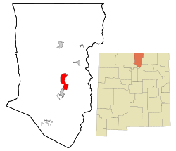
Ranchos de Taos is a census-designated place (CDP) in Taos County, New Mexico. The population was 2,390 at the time of the 2000 census.

<span class="mw-page-title-main">Rio Lucio, New Mexico</span> CDP in New Mexico, United States

Rio Lucio is a census-designated place (CDP) in Taos County, New Mexico, United States. The population was 379 at the 2000 census.

<span class="mw-page-title-main">Vadito, New Mexico</span> CDP in New Mexico, United States

Vadito is a census-designated place (CDP) in southern Taos County, New Mexico, United States. It is on the scenic High Road to Taos. The population was 270 at the 2010 census.

<span class="mw-page-title-main">Redford, Texas</span> CDP in Texas, United States

Redford is a census-designated place (CDP) in Presidio County, Texas, United States. The population was 90 at the 2010 census.

<span class="mw-page-title-main">Lake Marcel-Stillwater, Washington</span> Census-designated place in Washington, United States

Lake Marcel-Stillwater is a census-designated place (CDP) in King County, Washington, United States. The population was 1,277 at the 2010 census.

<span class="mw-page-title-main">Peñasco, New Mexico</span> CDP in New Mexico, United States

Peñasco is a census-designated place (CDP) in Taos County, New Mexico. It is located along the scenic High Road to Taos. The population is estimated at 1,200 (2015).

<span class="mw-page-title-main">Velarde, New Mexico</span> Census-designated place in New Mexico, United States

Velarde is a census-designated place (CDP) in Rio Arriba County, New Mexico, United States. The population was 502 at the time of the 2010 census. Velarde is located on New Mexico State Road 68, in the Rio Grande Rift, at the point where the road enters the Rio Grande Gorge.

References

  1. "ArcGIS REST Services Directory". United States Census Bureau. Retrieved October 12, 2022.
  2. 1 2 "Census Population API". United States Census Bureau. Retrieved October 12, 2022.
  3. "US Gazetteer files: 2010, 2000, and 1990". United States Census Bureau. February 12, 2011. Retrieved April 23, 2011.
  4. "Census of Population and Housing". Census.gov. Retrieved June 4, 2016.
  5. "U.S. Census website". United States Census Bureau . Retrieved January 31, 2008.
  6. "2020 CENSUS - SCHOOL DISTRICT REFERENCE MAP: Taos County, NM" (PDF). U.S. Census Bureau . Retrieved July 12, 2022.
  7. "Taos Day School". Bureau of Indian Education . Retrieved March 16, 2023. Physical Address: 200 Rotten Tree Rd Taos, NM 87571 - Despite the Taos address, it is in Taos Pueblo CDP