
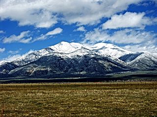
Taos is a town in Taos County in the north-central region of New Mexico in the Sangre de Cristo Mountains. Initially founded in 1615, it was intermittently occupied until its formal establishment in 1795 by Nuevo México Governor Fernando Chacón to act as fortified plaza and trading outpost for the neighboring Native American Taos Pueblo and Hispano communities, including Ranchos de Taos, Cañon, Taos Canyon, Ranchitos, El Prado, and Arroyo Seco. The town was incorporated in 1934. As of the 2010 census, its population was 5,716.
Taos County is a county in the U.S. state of New Mexico. As of the 2020 census, the population was 34,489. Its county seat is Taos. The county was formed in 1852 as one of the original nine counties in New Mexico Territory.

Santa Fe County is located in the U.S. state of New Mexico. As of the 2010 census, the population was 144,170, making it New Mexico's third-most populous county, after Bernalillo County and Doña Ana County. Its county seat is Santa Fe, the state capital.

Rio Arriba County is a county in the U.S. state of New Mexico. As of the 2010 census, the population was 40,246. Its county seat is Tierra Amarilla. Its northern border is the Colorado state line.

La Cienega is a census-designated place (CDP) in Santa Fe County, New Mexico, United States. It is part of the Santa Fe, New Mexico, metropolitan statistical area. The population was 3,007 at the 2000 census.

Picuris Pueblo is a historic pueblo in Taos County, New Mexico, United States. It is also a census-designated place (CDP) and a federally recognized tribe of Native American Pueblo people. The 2010 census estimated that 68 people lived in the CDP, while 267 people in the U.S. reported being of the tribal group Picuris alone and 439 reported being of the tribal group Picuris alone or in combination with other groups. Picurís Pueblo is a member of the Eight Northern Pueblos. Their own name for their pueblo is P'įwweltha, meaning "mountain warrior place" or "mountain pass place." They speak the Picuris dialect of the Northern Tiwa language, part of the Kiowa-Tanoan language family.
Turley is both a surname and a given name. Notable people with the name include:

John David Albert was an American mountain man.
Mora or Santa Gertrudis de lo de Mora is a census-designated place in, and the county seat of, Mora County, New Mexico. It is located about halfway between Las Vegas and Taos on Highway 518, at an altitude of 7,180 feet. The Republic of Texas performed a semi-official raid on Mora in 1843. Two short battles of the Mexican–American War were fought in Mora in 1847, where U.S. troops eventually defeated the Hispano and Puebloan militia, effectively ending the Taos Revolt in the Mora Valley. The latter battle destroyed most of the community, necessitating its re-establishment.

The Taos Revolt was a populist insurrection in January 1847 by Hispano and Pueblo allies against the United States' occupation of present-day northern New Mexico during the Mexican–American War. Provisional governor Charles Bent and several other Americans were killed by the rebels. In two short campaigns, United States troops and militia crushed the rebellion of the Hispano and Pueblo people. The New Mexicans, seeking better representation, regrouped and fought three more engagements, but after being defeated, they abandoned open warfare. Hatred of New Mexicans for the occupying American army combined with the oft-exercised rebelliousness of Taos residents against authority imposed on them from elsewhere were causes of the revolt. In the aftermath of the revolt the Americans executed at least 28 rebels. The Treaty of Guadalupe Hidalgo in 1850 guaranteed the property rights of New Mexico's Hispanic and American Indian residents.
Tom Tobin (1823–1904) was an American adventurer, tracker, trapper, mountain man, guide, US Army scout, and occasional bounty hunter. Tobin explored much of southern Colorado, including the Pueblo area. He associated with men such as Kit Carson, "Uncle Dick" Wootton, Ceran St. Vrain, Charley Bent, John C. Fremont, "Wild Bill" Hickok, William F. Cody, and the Shoup brothers. Tobin was one of only two men to escape alive from the siege of Turley's Mill and Distillery during the Taos Revolt. In later years he was sent by the Army to track down and kill the notorious Felipe Espinosa and his nephew; Tobin returned to Ft. Garland with their heads in a sack.
El Prado is an unincorporated suburb on the north side of Taos, in Taos County, New Mexico, United States. It is generally bounded on the south by the town of Taos, to the east by Taos Pueblo lands, to the north by Arroyo Seco and Arroyo Hondo, and to the west by the Rio Grande Gorge. The elevation is 7,123 feet. U.S. Route 64 and New Mexico State Roads 150 and 522 run through El Prado.

Velarde is a census-designated place (CDP) in Rio Arriba County, New Mexico, United States. The population was 502 at the time of the 2010 census. Velarde is located on New Mexico State Road 68, in the Rio Grande Rift, at the point where the road enters the Rio Grande Gorge.
Peak Place is an unincorporated community and census-designated place in Santa Fe County, New Mexico, United States. Its population was 377 as of the 2010 census.
The Turley Mill and Distillery Site is a historic site on the Rio Hondo about 11 miles (18 km) north of Taos, New Mexico. It was a mill and distillery which served as the headquarters of Simeon Turley's commercial and manufacturing empire. Simeon Turley (1809–1847) and his brothers Stephen Turley (1786–1851) and Jesse B. Turley (1801–1861) transported goods from Franklin, Missouri to Taos via wagon train on the Santa Fe Trail. About 1827–1829 Simeon settled in Arroyo Hondo and established the mill and distillery as a popular trading post and "watering hole." Simeon was murdered in the Taos Revolt of January 1847 and the mill and distillery site was all but destroyed. Simeon Turley is buried in the Kit Carson Memorial Cemetery in Taos. The mill and distillery site was listed on the State of New Mexico Register of Cultural Properties in 1969 and on the National Register of Historic Places in 1978.
Taos Valley, also called Lower Taos Canyon, is a valley located in Taos County, New Mexico. It is bounded by the Rio Grande Gorge; the deep ravine, or Arroyo Hondo, of the Rio Hondo; and the Taos Mountain range. Included in the valley are Ranchos de Taos, the Taos Pueblo, and Taos Plaza.
Arroyo Hondo is an unincorporated community and census-designated place (CDP) in Santa Fe County, New Mexico, United States. It was first listed as a CDP prior to the 2020 census.
Conejo is an unincorporated community and census-designated place (CDP) in Santa Fe County, New Mexico, United States. It was first listed as a CDP prior to the 2020 census.
Sunlit Hills is an unincorporated community and census-designated place (CDP) in Santa Fe County, New Mexico, United States. It was first listed as a CDP prior to the 2020 census.
Tres Arroyos is an unincorporated community and census-designated place (CDP) in Santa Fe County, New Mexico, United States. It was first listed as a CDP prior to the 2020 census.


