Rio Lucio, New Mexico

Last updated

Rio Lucio, New Mexico
CDP
Rio Lucio, New Mexico - Chapel of Sagrado Corazon de Jesus - panoramio.jpg
Chapel of Sagrado Corazón de Jesús in Rio Lucio
Taos County New Mexico Incorporated and Unincorporated areas Rio Lucio Highlighted.svg
Location of Rio Lucio, New Mexico
Usa edcp location map.svg
Red pog.svg
Rio Lucio, New Mexico
Location in the United States
Coordinates: 36°11′30″N105°43′10″W / 36.19167°N 105.71944°W / 36.19167; -105.71944
Country United States
State New Mexico
County Taos
Area
[1]
  Total1.05 sq mi (2.72 km2)
  Land1.05 sq mi (2.72 km2)
  Water0.00 sq mi (0.00 km2)
Elevation
7,251 ft (2,210 m)
Population
 (2020) [2]
  Total303
  Density288.02/sq mi (111.25/km2)
Time zone UTC-7 (Mountain (MST))
  Summer (DST) UTC-6 (MDT)
ZIP code
87553
Area code 505
FIPS code 35-63250
GNIS feature ID0910245

Rio Lucio is a census-designated place (CDP) in Taos County, New Mexico, United States. The population was 379 at the 2000 census.

Contents

Geography

Rio Lucio is located at 36°11′30″N105°43′10″W / 36.19167°N 105.71944°W / 36.19167; -105.71944 (36.191598, -105.719315). [3]

According to the United States Census Bureau, the CDP has a total area of 1.1 square miles (2.8 km2), all land.

Demographics

Historical population
CensusPop.Note
2020 303
U.S. Decennial Census [4] [2]

As of the census [5] of 2000, there were 379 people, 146 households, and 115 families residing in the CDP. The population density was 354.8 inhabitants per square mile (137.0/km2). There were 187 housing units at an average density of 175.1 per square mile (67.6/km2). The racial makeup of the CDP was 35.36% White, 3.43% Native American, 55.94% from other races, and 5.28% from two or more races. Hispanic or Latino of any race were 93.40% of the population.

There were 146 households, out of which 36.3% had children under the age of 18 living with them, 50.0% were married couples living together, 21.9% had a female householder with no husband present, and 21.2% were non-families. 20.5% of all households were made up of individuals, and 8.9% had someone living alone who was 65 years of age or older. The average household size was 2.60 and the average family size was 2.94.

In the CDP, the population was spread out, with 26.6% under the age of 18, 7.7% from 18 to 24, 26.1% from 25 to 44, 24.8% from 45 to 64, and 14.8% who were 65 years of age or older. The median age was 38 years. For every 100 females, there were 99.5 males. For every 100 females age 18 and over, there were 93.1 males.

The median income for a household in the CDP was $24,107, and the median income for a family was $22,292. Males had a median income of $23,393 versus $20,375 for females. The per capita income for the CDP was $11,827. About 17.9% of families and 21.7% of the population were below the poverty line, including 36.9% of those under age 18 and 26.3% of those age 65 or over.

Education

The community is in the Peñasco Independent School District. [6]

Related Research Articles

<span class="mw-page-title-main">Taos County, New Mexico</span> County in New Mexico, United States

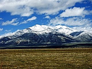
Taos County is a county in the U.S. state of New Mexico. As of the 2020 census, the population was 34,489. Its county seat is Taos. The county was formed in 1852 as one of the original nine counties in New Mexico Territory.

<span class="mw-page-title-main">Rock Point, Arizona</span> CDP in Apache County, Arizona

Rock Point is a census-designated place (CDP) in Apache County, Arizona, United States. The population was 642 at the 2010 census. Its name is descriptive of the point where Chinle Creek enters high sandstone walls.

<span class="mw-page-title-main">Tipton, California</span> Census-designated place in California, United States

Tipton is a census-designated place (CDP) in Tulare County, California, United States. The population was 2,543 at the 2010 census, up from 1,790 at the 2000 census.

Carver Ranches was a census-designated place (CDP) in Broward County, Florida, United States. The population was 4,299 at the 2000 census.

<span class="mw-page-title-main">Molino, Florida</span> Census-designated place in Florida, United States

Molino is a census-designated place (CDP) in Escambia County, Florida, United States. The population was 1,277 at the 2010 census. It is part of the Pensacola–Ferry Pass–Brent Metropolitan Statistical Area.

<span class="mw-page-title-main">Waipiʻo Acres, Hawaii</span> Census-designated place in Hawaii, United States

Waipiʻo Acres is a census-designated place (CDP) in Honolulu County, Hawaiʻi, United States. The population was 5,531 at the 2020 census.

Claiborne is an unincorporated community and census-designated place (CDP) in Ouachita Parish, Louisiana, United States. The population was 9,830 at the 2000 census. It is part of the Monroe Metropolitan Statistical Area.

<span class="mw-page-title-main">Wye, Montana</span> Place in Montana, United States

Wye is a unincorporated community in Missoula County, Montana, United States. It is part of the Missoula, Montana Metropolitan Statistical Area. The population was 511 at the 2010 census, an increase from its population of 381 in 2000. For statistical purposes, the United States Census Bureau has defined Saticoy as a census-designated place (CDP). Wye is named for the "y"-shaped DeSmet Junction where US 93 and MT 200 met former US 10.

<span class="mw-page-title-main">Sanostee, New Mexico</span> CDP in New Mexico, United States

Sanostee is a census-designated place (CDP) in San Juan County, New Mexico, United States. The population was 429 at the 2000 census. It is part of the Farmington Metropolitan Statistical Area.

<span class="mw-page-title-main">Rio Chiquito, New Mexico</span> CDP in New Mexico, United States

Rio Chiquito is a census-designated place in Santa Fe County, New Mexico, United States. It is part of the Santa Fe, New Mexico Metropolitan Statistical Area. The population was 103 at the 2000 census.

<span class="mw-page-title-main">Rio en Medio, New Mexico</span> CDP in New Mexico, United States

Rio en Medio is a census-designated place (CDP) in Santa Fe County, New Mexico, United States. It is part of the Santa Fe, New Mexico Metropolitan Statistical Area. The population was 131 at the 2000 census.

<span class="mw-page-title-main">Chamisal, New Mexico</span> Census-designated place in Taos County, New Mexico, United States

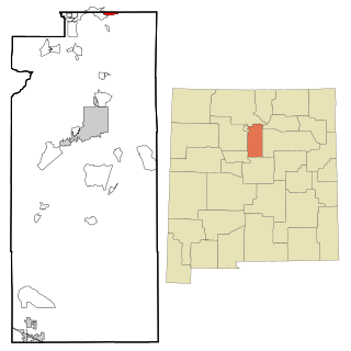
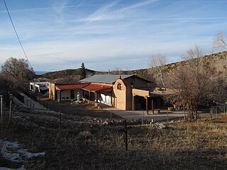
Chamisal is a census-designated place (CDP) in Taos County, New Mexico. It is located along the scenic High Road to Taos. The population was 301 at the time of the 2000 census.

<span class="mw-page-title-main">Taos Pueblo, New Mexico</span> CDP in New Mexico, United States

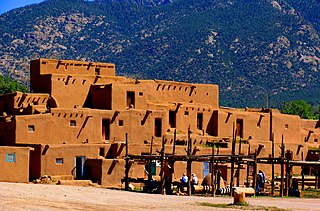
Taos Pueblo is a census-designated place (CDP) in Taos County, New Mexico, just north of Taos. The population was 1,264 at the 2000 census.

<span class="mw-page-title-main">Vadito, New Mexico</span> CDP in New Mexico, United States

Vadito is a census-designated place (CDP) in southern Taos County, New Mexico, United States. It is on the scenic High Road to Taos. The population was 270 at the 2010 census.

<span class="mw-page-title-main">Netarts, Oregon</span> Unincorporated community in the state of Oregon, United States

Netarts is an unincorporated community in Tillamook County, Oregon, United States; it is a census-designated place (CDP). The population was 744 at the 2000 census.

<span class="mw-page-title-main">Plymptonville, Pennsylvania</span> Census-designated place in Pennsylvania, United States

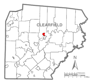
Plymptonville is a census-designated place (CDP) in Clearfield County, Pennsylvania, United States. The population was 972 at the 2020 census.

<span class="mw-page-title-main">Antelope, South Dakota</span> CDP in South Dakota, United States

Antelope is a census-designated place (CDP) in Todd County, South Dakota, United States. The population was 830 at the 2020 census.

<span class="mw-page-title-main">Los Alvarez, Texas</span> CDP in Texas, United States

Los Alvarez is a census-designated place (CDP) in Starr County, Texas, United States. The population was 303 at the 2010 census down from 1,434 at the 2000 census.

<span class="mw-page-title-main">Peñasco, New Mexico</span> CDP in New Mexico, United States

Peñasco is a census-designated place (CDP) in Taos County, New Mexico. It is located along the scenic High Road to Taos. The population is estimated at 1,200 (2015).

<span class="mw-page-title-main">Velarde, New Mexico</span>

Velarde is a census-designated place (CDP) in Rio Arriba County, New Mexico, United States. The population was 502 at the time of the 2010 census. Velarde is located on New Mexico State Road 68, in the Rio Grande Rift, at the point where the road enters the Rio Grande Gorge.

References

  1. "ArcGIS REST Services Directory". United States Census Bureau. Retrieved October 12, 2022.
  2. 1 2 "Census Population API". United States Census Bureau. Retrieved October 12, 2022.
  3. "US Gazetteer files: 2010, 2000, and 1990". United States Census Bureau. February 12, 2011. Retrieved April 23, 2011.
  4. "Census of Population and Housing". Census.gov. Retrieved June 4, 2016.
  5. "U.S. Census website". United States Census Bureau . Retrieved January 31, 2008.
  6. "2020 CENSUS - SCHOOL DISTRICT REFERENCE MAP: Taos County, NM" (PDF). U.S. Census Bureau . Retrieved July 13, 2022.