Cilandak is a district of South Jakarta, Indonesia. The Krukut River flows through the eastern edge of Cilandak, while the Pesanggrahan and Grogol Rivers flow through the western edge.

Tanjung Priok is a district of North Jakarta, Indonesia. It hosts the western part of the city's main harbor, the Port of Tanjung Priok. The district of Tanjung Priok is bounded by Laksamana Yos Sudarso Tollway and Sunter River canal to the east, by Kali Japat, Kali Ancol, and the former Kemayoran Airport to the southwest, by Sunter Jaya Road and Sunter Kemayoran Road to the south, and by Jakarta Bay to the north.

West Jakarta is one of the five administrative cities of the Special Capital Region of Jakarta, Indonesia. West Jakarta is not self-governed and does not have a city council, hence it is not classified as a proper municipality. It had a population of 2,281,945 at the 2010 Census and 2,434,511 at the 2020 Census. The administrative center of West Jakarta is at Puri Kembangan.

Duren Sawit is a district (kecamatan) of East Jakarta, Indonesia. The rough boundaries of Duren Sawit are I. Gusti Ngurah Rai road to the north, Kali Sunter to the west, and Kali Malang to the south. The district borders the districts of Jatinegara to the west, Cakung and Pulo Gadung to the north, and Makasar to the south, and Bekasi to the east.

Kembangan is a district in West Jakarta, Indonesia. Kembangan is bounded by Pesanggrahan Subdistrict to the south, Tangerang Regency to the south and west, Cengkareng Subdistrict to the north, and Kebon Jeruk Subdistrict to the east. The City Hall of West Jakarta is located in this district.

Cempaka Putih is a district of Central Jakarta, Indonesia. Cempaka Putih is roughly bounded by Jenderal Ahmad Yani bypass highway to the east, Pramuka boulevard to the south, Letjend Suprapto boulevard to the north, and a railway line to the west. The name "Cempaka Putih" derived from flowering plant white champaca.
Makasar is a district (kecamatan) of East Jakarta, Indonesia. It had an area of 21.85 km² and population of 185,830 at the 2010 Census; the latest official estimate is 204,595.
Jagakarsa is a district of South Jakarta, one of the administrative cities in Jakarta Indonesia. Jagakarsa is the southernmost district of South Jakarta Jagakarsa District is bounded by Ciliwung River to the east, Krukut River to the west, and Margasatwa-Sagu-Joe-T.B.Simatupang-Poltangan Road to the north, while the boundary marches with Depok city to the south.

Kebayoran Lama is a district of South Jakarta, Indonesia. The rough boundaries of Kebayoran Lama are: Kebayoran Lama Road – Palmerah Barat Road to the north, Grogol River to the east, Jakarat Outer Ring Road to the south, and Pesanggrahan River to the west.

Pademangan is a port-associated subdistrict of North Jakarta, Indonesia. It stretches from the Sunda Kelapa Harbor on the east to the western area of Tanjung Priok Harbor to the east. Geographically, it is a plain with an average height of 75 centimeters above the high tide sea level.

Pondok Aren is a district in South Tangerang City, Banten Province, Indonesia. It is located on the south-western outskirts of Jakarta. The area covers 29.88 km2 and had a population at the 2020 Census of 294,996. Pondok Aren district mainly covers the area of Bintaro Jaya and borders South Jakarta to the east. Pondok Aren district office is located at Jl. Graha Raya Bintaro, Perigi Baru behind the Pondok Aren Sectoral Police office.

The MetroMini minibus system is major part of the public transport system of Jakarta. There were reportedly over 3,000 buses in the MetroMini fleet in mid-2012. The buses are similar to the parallel Kopaja system which also provides transport services, on different routes, across Jakarta. The distinctive MetroMini buses are orange and blue with a white stripe running along the length of the bus. Buses provide seating for around 20-30 people with, often, an equal number crammed into limited standing room so the buses are often overcrowded. But at 2015 Jakarta Governor Basuki Tjahaja Purnama stopped all of MetroMini's bus operations because of a MetroMini vs KRL Commuter Line crash. If MetroMini wants to operate again, it has to join Transjakarta like the Kopaja as a feeder bus. Many routes are/will replaced/replaced by Minitrans and Metrotrans buses.
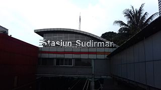
Sudirman Station is a train station of KRL Commuterline, which is located in Menteng, Central Jakarta, Indonesia. The station is named from Jalan Jenderal Sudirman, one of the main avenue in Jakarta, which crosses above the station. This station is located on the north bank of West Flood Canal. Though this station serves only Commuterline trains, but it is a transit point for other types of public transportation as part of Dukuh Atas TOD.

Pantai Indah Kapuk (PIK) is a gated community, located in parts of Penjaringan, North Jakarta and Kapuk, West Jakarta, Indonesia. It is one of most prestigious residential areas in Jakarta along with Menteng, Pondok Indah, and Puri Indah.

Puri Indah is a growing neighborhood at Kembangan, Jakarta, Indonesia. The area is in between South Kembangan and North Meruya administrative village of Kembangan district of West Jakarta. The area is located at the intersection of W1-W2 toll/expressway of the Jakarta Outer Ring Road.

The following outline is provided as an overview of and topical guide to Jakarta:
