Circuito Sur de Oriente

Last updated
Circuito Sur de Oriente (CSO)
Southern Circuit of the Orient
Circuito Sur de Oriente map (Cuba).png
Carretera Granma2.jpg
The CSO across the municipality of Guamá
with the Sierra Maestra in background
Route information
Length347 km (216 mi)
Major junctions
West end Bayamo (Granma Province)
East end Santiago (Santiago Province)
Location
Country Cuba
Major cities Bayamo, Manzanillo, Campechuela, Niquero, Pilón, Chivirico, Santiago de Cuba
Highway system
The CSO across the coastline of Guama Carretera Granma1.jpg
The CSO across the coastline of Guamá
The CSO east of Caleton blanco, Guama Guama 294A9699 Caleton Blanco Cuba.jpg
The CSO east of Caleton blanco, Guama

The Circuito Sur de Oriente (CSO), meaning "Southern Circuit of the Orient", is a west-east highway connecting Bayamo to Santiago de Cuba, through Manzanillo, Niquero and the southern coastal side of eastern Cuba, below the Sierra Maestra mountain range. [1] Also known as Circuito Guacanayabo-Sur de Oriente, because it crosses the Gulf of Guacanayabo, the name Oriente (meaning "Orient"), refers to the ancient and former Oriente Province. With a length of 347 km, it is the fourth-longest Cuban highway after the "Carretera Central", the "Circuito Norte" and the "Circuito Sur".

Contents

Route

Description

The CSO, whose endpoints cross the Carretera Central, starts in Bayamo, capital of Granma Province, and ends in Santiago, the second Cuban city and capital of Santiago de Cuba Province. It is divided into a pair of Carretera branches:

Table

The table below shows the route of the Circuito Sur de Oriente. [1] Note: Provincial seats are shown in bold; the names shown under brackets in the section "Municipality" indicate the municipal seats.

SettlementMunicipalityProvince
Bayamo (Bayamo) Granma
Santa Rosa (to El Dátil) Bayamo Granma
William Soler (crossroad) Bayamo Granma
Solis Bayamo Granma
El Dorado (University of Granma) Bayamo Granma
Peralejo Bayamo Granma
Entronque Bueycito (to Bueycito) Bayamo Granma
Barranca (to Julia-Mabay) Bayamo Granma
Los Cayos Yara Granma
Repelón Yara Granma
Macuto Yara Granma
Veguitas Yara Granma
Sofía (crossroad) Yara Granma
Yara (Yara)Granma
Coboa Yara Granma
Cayo Redondo Yara Granma
Las Novillas Manzanillo Granma
Blanquizal Manzanillo Granma
Manzanillo (Manzanillo)Granma
San Francisco Manzanillo Granma
El Congo Manzanillo Granma
Los Letreros Manzanillo Granma
La Demajagua (crossroad) Manzanillo Granma
San Antonio Manzanillo Granma
Calicito (to Troya) Manzanillo Granma
Israel Licea Campechuela Granma
El Puntico Campechuela Granma
Campechuela (Campechuela)Granma
Ceiba Hueca Campechuela Granma
San Ramón Campechuela Granma
Media Luna (Media Luna)Granma
San Diego Media Luna Granma
Entronque Niquero-Pilón (to Niquero) Media Luna Granma
Fairytale down.png Media Luna–Niquero–Cabo Cruz fork section Fairytale down.png (start)
Entronque Niquero-Pilón (to Pilón) Media Luna Granma
Santa Isabel Niquero Granma
Jagua Niquero Granma
Niquero (Niquero)Granma
Guanito Niquero Granma
Hondón Niquero Granma
Marea de Limones Niquero Granma
Marea de Belic Niquero Granma
Belic Niquero Granma
Palma de la Cruz Niquero Granma
Playa Las Coloradas Niquero Granma
Cabo Cruz Niquero Granma
Fairytale up.png Media Luna–Niquero–Cabo Cruz fork section Fairytale up.png (end)
Entronque Niquero-Pilón (to Niquero) Media Luna Granma
La Junta Media Luna Granma
Blanca Rosa Media Luna Granma
Sevilla Arriba Pilón Granma
La Alegría Pilón Granma
Pilón (Pilón)Granma
Saturnino Pilón Granma
Punta de Piedra Pilón Granma
Marea del Portillo Pilón Granma
Mota Pilón Granma
Buenavista (crossroad) Pilón Granma
El Macho Guamá Santiago
La Magdalena Guamá Santiago
La Plata Guamá Santiago
Las Cuevas Guamá Santiago
Ocujal Guamá Santiago
La Mula Guamá Santiago
La Uvita Guamá Santiago
Uvero Guamá Santiago
Guamá Abajo Guamá Santiago
Chivirico (Guamá)Santiago
Cayo Damas Guamá Santiago
Quiebra Seca Guamá Santiago
Río Seco Guamá Santiago
El Francés Guamá Santiago
Aserradero Guamá Santiago
Dos Ríos Guamá Santiago
Caletón Blanco Guamá Santiago
Cañizo Guamá Santiago
Juan González Guamá Santiago
Buey Cabón Guamá Santiago
Mar Verde Santiago de Cuba Santiago
Oanones Santiago de Cuba Santiago
El Carmen (to El Cobre and Parada) Santiago de Cuba Santiago
Santiago de Cuba (Santiago de Cuba)Santiago

See also

Related Research Articles

<span class="mw-page-title-main">Granma Province</span> Province of Cuba

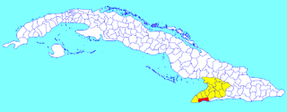
Granma is one of the provinces of Cuba. Its capital is Bayamo. Other towns include Manzanillo and Pilón.

<span class="mw-page-title-main">Manzanillo, Cuba</span> Municipality in Granma, Cuba

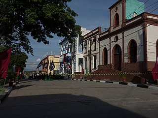
Manzanillo is a municipality and city in the Granma Province of Cuba. By population, it is the 14th-largest Cuban city and the most populated one not being a provincial seat.

<span class="mw-page-title-main">Bayamo</span> Municipality in Granma, Cuba

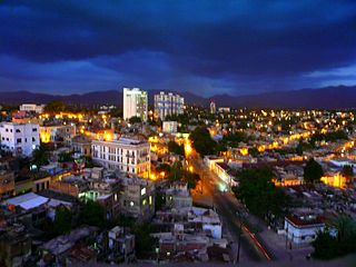
Bayamo is the capital city of the Granma Province of Cuba and one of the largest cities in the Oriente region.

<span class="mw-page-title-main">Sierra Maestra</span> Mountain range of Cuba

The Sierra Maestra is a mountain range that runs westward across the south of the old Oriente Province in southeast Cuba, rising abruptly from the coast. The range falls mainly within the Santiago de Cuba and in Granma Provinces. Some view it as a series of connecting ranges, which join with others to the west. At 1,974 m (6,476 ft), Pico Turquino is the range's – and the country's – highest point. The area is rich in minerals, especially copper, manganese, chromium, and iron.

<span class="mw-page-title-main">Palma Soriano</span> District in Oriente, Cuba

Palma Soriano is a Cuban city and municipality in the Santiago de Cuba Province. With a population of 119,740 in the city proper, it is the second-largest in the province and the 16th-largest in Cuba.

<span class="mw-page-title-main">Yara, Cuba</span> Municipality in Granma, Cuba

Yara is a small town and municipality in the Granma Province of Cuba, located halfway between the cities of Bayamo and Manzanillo, in the Gulf of Guacanayabo. Yara means "place" in the Taíno language.

<span class="mw-page-title-main">Campechuela</span> Municipality in Granma, Cuba

Campechuela is a municipality and town in Granma Province of Cuba. It is located on the southern shore of the Gulf of Guacanayabo.

<span class="mw-page-title-main">Desembarco del Granma National Park</span> National park

Desembarco del Granma National Park is a national park in south-western Cuba, stretching across the Niquero and Pilón municipalities in what is now Granma Province. The name of the park means "Landing of the Granma" and refers to the yacht in which Fidel Castro, Che Guevara, Raúl Castro, and 79 of their supporters sailed from Mexico to Cuba in 1956 and incited the Cuban Revolution. The National park is well known for its karst topography and coastal cliffs.

Frank País García was a Cuban revolutionary who campaigned for the overthrow of General Fulgencio Batista's government in Cuba. País was the urban coordinator of the 26th of July Movement, and was a key organizer within the urban underground movement, collaborating with Fidel Castro's guerrilla forces which were conducting activities in the Sierra Maestra mountains. País was killed in the streets of Santiago de Cuba by the Santiago police on July 30, 1957.

<span class="mw-page-title-main">Guamá, Cuba</span> Municipality in Santiago de Cuba, Cuba

Guamá is a municipality in the Santiago de Cuba Province of Cuba. The municipal seat is located in the town of Chivirico. It was named after Guamá, the Taíno cacique who led a rebellion against the Spanish 1530s.

<span class="mw-page-title-main">Pilón, Cuba</span> Municipality in Granma, Cuba

Pilón is a municipality and town in the Granma Province of Cuba. It is located on the southern coast of Cuba, in an inlet of the Caribbean Sea.

<span class="mw-page-title-main">Media Luna, Cuba</span> Municipality in Granma, Cuba

Media Luna is a town and municipality in the Granma Province of Cuba. It is located on the coastal region of the province, bordering the Gulf of Guacanayabo, between Niquero and Campechuela.

<span class="mw-page-title-main">Niquero</span> Municipality in Granma, Cuba

Niquero is a municipality and town in the Granma Province of Cuba. It is located in the coastal region of the province, bordering the Gulf of Guacanayabo. Cape Cruz, the westernmost point of the province is located in this municipality.

<span class="mw-page-title-main">Cape Cruz</span> Cape in southern Cuba

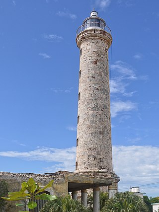
Cape Cruz,, is a cape that forms the western extremity of the Granma Province in southern Cuba. It extends into the Caribbean sea and marks the eastern border of the Gulf of Guacanayabo. Cape Cruz is located in the municipality of Niquero and is part of the Desembarco del Granma National Park.

<span class="mw-page-title-main">Roads in Cuba</span> Highway system in Cuba

The road network of Cuba consists of 60,858 km (37,815 mi) of roads, of which over 29,850 km (18,550 mi) are paved and 31,038 km (19,286 mi) are unpaved. The Caribbean country counts also 654 km (406 mi) of motorways (autopistas).

<span class="mw-page-title-main">Uvero</span> Village in Santiago de Cuba, Cuba

Uvero, also known as El Uvero, is a Cuban village and consejo popular of the municipality of Guamá, in Santiago de Cuba Province. In 2011 it had a population of 2,581.

<span class="mw-page-title-main">Circuito Norte</span>

The Circuito Norte (CN), meaning "Northern Circuit", is a west-east highway spanning the length of the island of Cuba, through the Atlantic Coast. With a length of 1,222 km, it is the second-longest Cuban highway, after the "Carretera Central"; and two sections of it, named "Vía Blanca" and "Panamericana", are classified as Expressways.

<span class="mw-page-title-main">Circuito Sur</span>

The Circuito Sur (CS), meaning "Southern Circuit", is a west-east highway connecting Artemisa to Sancti Spíritus, through the southern and coastal side of central-western Cuba. With a length of 491 km, it is the third-longest Cuban highway after the "Carretera Central" and the "Circuito Norte".

<span class="mw-page-title-main">Battle of Peralejo</span>

The Battle of Peralejo was a military confrontation between Cuban independence rebels, under the command of Major General Antonio Maceo against the forces of the Spanish Army, under the command of Captain General Arsenio Martínez Campos, which was part of Maceo's First Eastern Campaign during the Cuban War of Independence.

References

  1. 1 2 Source: Mapa de Carreteras de Cuba (Road map of Cuba). Ediciones GEO, Havana 2011 - ISBN   959-7049-21-X

Commons-logo.svg Media related to Circuito Sur de Oriente at Wikimedia Commons

20°22′01.6″N76°38′32.2″W / 20.367111°N 76.642278°W / 20.367111; -76.642278