Citrus Springs, Florida

Last updated

Citrus Springs
Citrus Springs, Florida; West Gateway-2.JPG
The gateway to Citrus Springs on the west side of US 41
Citrus County Florida Incorporated and Unincorporated areas Citrus Springs Highlighted.svg
Location in Citrus County and the state of Florida
Coordinates: 28°59′37″N82°27′42″W / 28.99361°N 82.46167°W / 28.99361; -82.46167
Country Flag of the United States.svg  United States
State Flag of Florida.svg  Florida
County   Citrus
Government
  TypeUnelected Council Government
  Body Citrus Springs Advisory Council
Area
[1]
  Total21.15 sq mi (54.77 km2)
  Land21.15 sq mi (54.77 km2)
  Water0.00 sq mi (0.00 km2)
Elevation
95 ft (29 m)
Population
 (2020)
  Total10,246
  Density484.54/sq mi (187.08/km2)
Time zone UTC-5 (Eastern (EST))
  Summer (DST) UTC-4 (EDT)
ZIP codes
34433-34434
Area code 352
FIPS code 12-12450 [2]
GNIS feature ID0304634 [3]

Citrus Springs is a census-designated place (CDP) in Citrus County, Florida, United States. The population was 10,246 at the 2020 census, up from 8,622 at the 2010 census. [4] It is part of the Homosassa Springs, Florida Metropolitan Statistical Area.

Contents

Geography

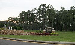
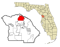
Citrus Springs is located in northern Citrus County at 28°59′37″N82°27′42″W / 28.99361°N 82.46167°W / 28.99361; -82.46167 (28.993539, -82.461692). [5] It is bordered by Pine Ridge to the south and Hernando to the east. U.S. Route 41 (North Florida Avenue) runs through the CDP, leading southeast 15 miles (24 km) to Inverness, the Citrus County seat, and north 3 miles (5 km) to Dunnellon in Marion County.

According to the United States Census Bureau, Citrus Springs has a total area of 21.2 square miles (54.8 km2); all land. [4]

Demographics

Historical population
CensusPop.Note
1990 2,213
2000 4,15787.8%
2010 8,622107.4%
2020 10,24618.8%
U.S. Decennial Census [6]

As of the census [2] of 2000, there were 4,157 people, 1,834 households, and 1,333 families residing in the CDP. The population density was 195.4 inhabitants per square mile (75.4/km2). There were 2,003 housing units at an average density of 94.2 per square mile (36.4/km2). The racial makeup of the CDP was 93.70% White, 2.24% African American, 0.31% Native American, 0.65% Asian, 0.07% Pacific Islander, 1.37% from other races, and 1.66% from two or more races. Hispanic or Latino of any race were 5.46% of the population.

There were 1,834 households, out of which 20.1% had children under the age of 18 living with them, 62.4% were married couples living together, 8.5% had a female householder with no husband present, and 27.3% were non-families. 23.3% of all households were made up of individuals, and 16.4% had someone living alone who was 65 years of age or older. The average household size was 2.25 and the average family size was 2.61.

In the CDP, the population was spread out, with 18.0% under the age of 18, 4.2% from 18 to 24, 18.6% from 25 to 44, 22.9% from 45 to 64, and 36.3% who were 65 years of age or older. The median age was 54 years. For every 100 females, there were 88.4 males. For every 100 females age 18 and over, there were 85.8 males.

The median income for a household in the CDP was $29,758, and the median income for a family was $35,000. Males had a median income of $27,143 versus $18,686 for females. The per capita income for the CDP was $16,845. About 5.0% of families and 7.8% of the population were below the poverty line, including 11.4% of those under age 18 and 4.1% of those age 65 or over.

History

Citrus Springs was developed by the Mackle Brothers, prominent Florida real estate developers working under The Deltona Corporation to be used as a subdivision consisting of over 34,000 homesites. (Elkcam Boulevard, a prominent street in Citrus Springs, is "Mackle" spelled backwards.) The area currently has two elementary schools (Citrus Springs Elementary School and Central Ridge Elementary School, opened fall 2008) and one middle school (Citrus Springs Middle School). There are plans for an 80-acre (320,000 m2) high school campus complete with public park, but construction is not planned in the near future. [7]

Phosphate mining played a major part in the history of Citrus County until the end of World War II, when phosphate mining largely moved overseas. The first newspaper of Citrus County was called the Phosphate Times. Many abandoned mines exist in the Withlacoochee River basin, with a concentration of those within Citrus Springs. Some of those areas can be seen at one of Citrus Springs' two golf courses, El Diablo. Many of those mines were part of the Dunnellon Phosphate company, headed by Capt John L. Inglis, a veteran of the Civil War. Areas in northeastern Citrus Springs were part of a proposed but unbuilt portion of the Cross Florida Barge Canal to aid the transportation of the mineral.[ citation needed ]

The Withlacoochee State Trail, a 46-mile (74 km) bike riding trail which was converted from the railroad lines built in the early 1900s, runs through Citrus Springs, in places parallel to US 41. [8]

Education

The CDP is served by Citrus County Schools. [9] Residents are divided between Citrus Springs Elementary and Central Ridge Elementary. [10] All residents are zoned to Citrus Springs Middle School. [11] Portions of the CDP are zoned to Citrus High School, Crystal River High School, and Lecanto High School. [12]

Related Research Articles

<span class="mw-page-title-main">Crystal River, Florida</span> City in Florida, United States

Crystal River is a city in Citrus County, Florida, United States. The population was 3,396 in the 2020 census, up from 3,108 at the 2010 census. It is part of the Homosassa Springs, Florida Metropolitan Statistical Area. The city was incorporated in 1903 and is the self-professed "Home of the Manatee". Crystal River Preserve State Park is located nearby, and Crystal River Archaeological State Park is located in the city's northwest side.

<span class="mw-page-title-main">Beverly Hills, Florida</span> Census-designated place in Florida, United States

Beverly Hills is an unincorporated community and census-designated place in Citrus County, Florida, United States. The population was 9,961 at the 2020 census, up from 8,445 at the 2010 census. It is part of the Homosassa Springs, Florida Metropolitan Statistical Area.

<span class="mw-page-title-main">Black Diamond, Florida</span> Census-designated place in Florida, US

Black Diamond is a census-designated place (CDP) in Citrus County, Florida, United States. The population was 1,255 at the 2020 census, up from 1,101 at the 2010 census. It is part of the Homosassa Springs, Florida Metropolitan Statistical Area.

<span class="mw-page-title-main">Citrus Hills, Florida</span> Census-designated place in Florida, US

Citrus Hills is a census-designated place (CDP) in Citrus County, Florida, United States. The population was 9,302 at the 2020 census, up from 7,470 at the 2010 census. It is part of the Homosassa Springs, Florida Metropolitan Statistical Area.

<span class="mw-page-title-main">Floral City, Florida</span> Census-designated place in Florida, US

Floral City is a census-designated place (CDP) in Citrus County, Florida, United States. The population was 5,261 at the 2020 census, up from 5,217 at the 2010 census. It is part of the Homosassa Springs, Florida Metropolitan Statistical Area. The community is home to the Floral City Heritage Hall Museum and hosts the Floral City Heritage Days the first weekend in December. The area has a history of phosphate mining and includes historic homes.

<span class="mw-page-title-main">Hernando, Florida</span> Census-designated place in Florida, US

Hernando is a census-designated place in Citrus County, Florida, United States. The population was 9,284 at the 2020 census, up from 9,054 at the 2010 census. At one time it was a city but it was disincorporated in the 1970s. It is part of the Homosassa Springs, Florida Metropolitan Statistical Area.

<span class="mw-page-title-main">Homosassa, Florida</span> Census-designated place in Florida, United States

Homosassa is a census-designated place (CDP) in Citrus County, Florida, United States. The population was 2,299 at the 2020 census, down from 2,578 at the 2010 census. It is part of the Homosassa Springs, Florida Metropolitan Statistical Area.

<span class="mw-page-title-main">Homosassa Springs, Florida</span> Census-designated place in Florida, United States

Homosassa Springs is an unincorporated community and census-designated place (CDP) in Citrus County, Florida, United States. The population was 14,283 as of 2020, up from 13,791 at the 2010 census. Homosassa Springs is the principal community of the Homosassa Springs, Florida, Metropolitan Statistical Area.

<span class="mw-page-title-main">Inverness, Florida</span> City in Florida, United States

Inverness is a city and the county seat of Citrus County, Florida, United States. It is near the 10,950-acre (4,430 ha) Flying Eagle Preserve. As of the 2020 census, the population was 7,543, up from 7,210 at the 2010 census. It is part of the Homosassa Springs, Florida Metropolitan Statistical Area.

<span class="mw-page-title-main">Inverness Highlands North, Florida</span> Census-designated place in Florida, US

Inverness Highlands North is an unincorporated area and census-designated place (CDP) in Citrus County, Florida, United States. The population was 2,707 at the 2020 census, up from 2,401 at the 2010 census. It is part of the Homosassa Springs, Florida Metropolitan Statistical Area.

<span class="mw-page-title-main">Inverness Highlands South, Florida</span> Census-designated place in Florida, United States

Inverness Highlands South is a census-designated place (CDP) in Citrus County, Florida, United States. As of the 2020 census, the population was 6,698, up from 6,542 at the 2010 census. It is part of the Homosassa Springs, Florida Metropolitan Statistical Area.

<span class="mw-page-title-main">Lecanto, Florida</span> Census-designated place in Florida, US

Lecanto is an unincorporated community and census-designated place (CDP) in Citrus County, Florida, United States. As of the 2020 census it had a population of 6,301, up from 5,882 at the 2010 census. It is part of the Homosassa Springs, Florida Metropolitan Statistical Area. It is home to several county government facilities such as the Citrus County Sheriff's Office and the Citrus Campus of the College of Central Florida.

<span class="mw-page-title-main">Istachatta, Florida</span> Census-designated place in Florida, United States

Istachatta is an unincorporated community and census-designated place (CDP) in Hernando County, Florida, United States. The population was 116 at the 2010 census, up from 65 at the 2000 census. The name "Istachatta" is derived from a Seminole word meaning "man snake".

<span class="mw-page-title-main">Spring Hill, Florida</span> Census-designated place in Hernando County Florida, United States

Spring Hill is a census-designated place (CDP) in Hernando County, Florida, United States. The population was 113,568 at the 2020 census, up from 98,621 at the 2010 census. Spring Hill belongs to Florida's Nature Coast region and is in the Tampa-St. Petersburg-Clearwater metro area. It is east of Hernando Beach, southwest of Brooksville, and north of Tampa.

<span class="mw-page-title-main">Citrus Park, Florida</span> Census-designated place in Florida, United States

Citrus Park is an unincorporated census-designated place in Hillsborough County, Florida, United States. The population was 28,178 at the 2020 census, up from 24,252 at the 2010 census.

<span class="mw-page-title-main">Keystone, Florida</span> Census-designated place in Florida, United States

Keystone is an unincorporated census-designated place in Hillsborough County, Florida, United States. The Keystone area was first settled in the middle 1800s by the W.M. Mobley Family who migrated from Savannah, Georgia. The region has evolved from citrus and farming into a rural retreat of many lake homes and ranches. The population was 24,039 at the 2010 census, up from 14,627 at the 2000 census. The ZIP Codes encompassing the CDP area are 33556 and 33558.

<span class="mw-page-title-main">Dunnellon, Florida</span> City in Florida, United States

Dunnellon is a city in Marion County, Florida, United States. The population was 1,928 at the 2020 census, up from 1,733 in 2010. It is part of the Ocala Metropolitan Statistical Area.

<span class="mw-page-title-main">Orlo Vista, Florida</span> Census-designated place & Unincorporated community in Florida, United States

Orlo Vista is an unincorporated community and census-designated place in Orange County, Florida, United States. While the spelling "Orlo Vista" is used by the U.S. Postal Service, the community is shown as Orlovista on federal maps. The population of the Orlovista census-designated place was 6,123 at the 2010 census. It is part of the Orlando–Kissimmee Metropolitan Statistical Area. The boundaries of the Orlovista CDP are West Colonial Drive on the north, Pine Hills Road on the east, Old Winter Garden Road and Carter Street at the Orlando city limits on the south, and Hiawassee Road on the west.

<span class="mw-page-title-main">Pine Ridge, Citrus County, Florida</span> Census-designated place in Florida, US

Pine Ridge is an unincorporated community and census-designated place (CDP) in Citrus County, Florida, United States. The population was 11,042 at the 2020 census, up from 9,598 at the 2010 census. It is part of the Homosassa Springs, Florida Metropolitan Statistical Area.

<span class="mw-page-title-main">Olivarez, Texas</span> Census-designated place in Texas

Olivarez is a census-designated place (CDP) in Hidalgo County, Texas, United States. The population was 3,827 at the 2010 United States Census. It is part of the McAllen–Edinburg–Mission Metropolitan Statistical Area.

References

  1. "2020 U.S. Gazetteer Files". United States Census Bureau. Retrieved October 31, 2021.
  2. 1 2 "U.S. Census website". United States Census Bureau . Retrieved January 31, 2008.
  3. "US Board on Geographic Names". United States Geological Survey. October 25, 2007. Retrieved January 31, 2008.
  4. 1 2 "Geographic Identifiers: 2010 Demographic Profile Data (G001): Citrus Springs CDP, Florida". U.S. Census Bureau, American Factfinder. Archived from the original on February 12, 2020. Retrieved June 25, 2014.
  5. "US Gazetteer files: 2010, 2000, and 1990". United States Census Bureau. February 12, 2011. Retrieved April 23, 2011.
  6. "Census of Population and Housing". Census.gov. Retrieved June 4, 2016.
  7. http://www.citrus.k12.fl.us Archived 2009-02-27 at the Wayback Machine
  8. "Withlacoochee State Trail". Florida State Parks Guide. Absolutely Florida!. Retrieved November 4, 2022.
  9. "2010 CENSUS - CENSUS BLOCK MAP (INDEX): Citrus Springs CDP, FL." U.S. Census Bureau. Retrieved on February 3, 2017. See map pages. Compare this map to the attendance boundary maps of the school district.
  10. "Citrus County Elementary School Attendance Boundaries Archived 2015-02-26 at the Wayback Machine ." Citrus County Schools. Retrieved on February 2, 2017.
  11. "Citrus County Middle School Attendance Boundaries Archived 2015-02-26 at the Wayback Machine ." Citrus County Schools. Retrieved on February 2, 2017.
  12. "Citrus County High School Attendance Boundaries Archived 2015-02-26 at the Wayback Machine ." Citrus County Schools. Retrieved on February 2, 2017.