Related Research Articles
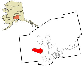
Skwentna is a census-designated place (CDP) on Iditarod Trail in Matanuska-Susitna Borough, Alaska, United States. Located 61 miles northwest of Wasilla along the Skwentna River, it is part of the Anchorage, Alaska Metropolitan Statistical Area. At the 2020 census the population was 62, up from 37 in 2010. The town is served by Skwentna Airport.

Nikolai is a city in Yukon-Koyukuk Census Area, Alaska, United States. The population was 94 as of the 2010 census, down from 100 in 2000.

Manila is a small city located on the northern edge of Daggett County, Utah, United States, just south of the Wyoming border. The town is at the junction of State Route 43 and State Route 44, and is the county seat of Daggett County. Nearby sites include the Flaming Gorge National Recreation Area and the Flaming Gorge Reservoir just east of town, and to the south is Ashley National Forest, which includes Kings Peak (13,528 ft), the highest point in Utah.

Fort Laramie is a town in Goshen County, Wyoming, United States. The population was 230 at the 2010 census. The town is named after historic Fort Laramie, an important stop on the Oregon, California and Mormon trails, as well as a staging point for various military excursions and treaty signings. The old fort was located south of town across the North Platte River, at the mouth of the Laramie River.

Smoot is a census-designated place (CDP) in Lincoln County, Wyoming, United States. The population was 195 at the 2010 census.

Wheatland is a town in and the county seat of Platte County in southeastern Wyoming, United States. The population was 3,627 at the 2010 census.

Upton is a town in Weston County, Wyoming, United States. The population was 898 at the 2020 census. The slogan of the town is: "The best town on earth".
Brimson is an unincorporated community in Ault Township, Saint Louis County, Minnesota, United States.

McClure Pass is a mountain pass in the Rocky Mountains of western Colorado in the United States. It is located along the boundary between Pitkin and Gunnison counties, in a gap at the western side of the Elk Mountains. The pass is at an elevation of 8,755 feet (2,669 m)) and separates the headwaters of the Crystal River to the east with the headwaters of the North Fork Gunnison River to the west. The pass is named in honor of Thomas "Mack" McClure who in the late 19th Century owned a large house at the eastern base of the pass. The house served as a stage stop where McClure fed and lodged travelers.

Cimarron is an unincorporated rural hamlet in Montrose County, Colorado, United States. It is located on the northern side of U.S. Highway 50, 19 miles from the town of Montrose to its west, and 42 miles from Gunnison, Colorado to its east. There is a store with fuel pumps and a post office at Cimarron. The post office services the rural ZIP Code 81220 area.

St. Mary is an unincorporated community on the western border of the Blackfeet Indian Reservation adjacent to Glacier National Park in Glacier County, Montana, United States. The village is the eastern terminus of the Going-to-the-Sun Road which bisects the park east to west, a distance of 53 mi (85 km).

The climate of California varies widely from hot desert to alpine tundra, depending on latitude, elevation, and proximity to the Pacific Coast. California's coastal regions, the Sierra Nevada foothills, and much of the Central Valley have a Mediterranean climate, with warmer, drier weather in summer and cooler, wetter weather in winter. The influence of the ocean generally moderates temperature extremes, creating warmer winters and substantially cooler summers in coastal areas.
Coalmont is an unincorporated community and U.S. Post Office in Jackson County, Colorado, United States. The town is named for the open-pit lignite coal mines in the area, from which coal was shipped out on the Union Pacific Railroad to the mainline at Laramie, Wyoming.
Dalton is an unincorporated census-designated place in the town of Kingston located in the southwestern corner of Green Lake County, Wisconsin, United States. It is located on Wisconsin Highway 44. It uses ZIP code 53926. As of the 2010 census, its population was 206. The surrounding countryside is mainly occupied by dairy farmers and an Amish community. Dalton has an area of 0.456 square miles (1.18 km2); 0.449 square miles (1.16 km2) of this is land, and 0.007 square miles (0.018 km2) is water. Dalton was named for John Dalton, who emigrated from Ireland with his family in the early 1850s.
Bitter Creek is an 80-mile-long stream in the U.S. state of Wyoming. It passes through several Wyoming counties including Sweetwater and Carbon. The creek rises near the Delaney Rim on the western side of Wyoming's Red Desert in Carbon County. For most of its course, Bitter Creek parallels the path of the transcontinental railroad, and the modern route of Interstate 80. It flows through the cities of Rock Springs and Green River before emptying into the Green River.
Old Roach is a ghost town in northwestern Larimer County, Colorado, United States. Once a company logging town, occupied roughly between 1923 and 1938, it lies in northern Colorado near the Wyoming border.

Beulah is a census-designated place (CDP) in eastern Crook County, Wyoming, United States, along Sand Creek, a tributary of the Belle Fourche River. According to local residents, the population is 33. When the 2010 census reported the population as 73, the highway sign at the town entrance was changed. In 2012, Beulah residents succeeded in appealing to the Wyoming Governor to remove the new sign and replace it with one that proclaimed the population to be 33.
Dixie is an unincorporated community in Idaho County, Idaho, United States, located 43 miles (69 km) east-northeast of Riggins. Dixie was an important gateway to the Thunder Mountain Mines of Idaho during the early 1900s when Dixie was on the northern terminus of the Three Blaze Trail, a shortcut route to the mines via Campbell's Ferry, and what is now the Frank Church-River of No Return Wilderness, Chamberlain Basin, and southward to the mining community of Roosevelt, located on Monumental Creek.
Muddy Mountain is a peak in the Laramie Mountains approximately 12 miles (19 km) south-south-east of Casper, Wyoming. There is a two-mile (3.2 km) "interpretive nature trail" maintained by the Bureau of Land Management, as well as a series of trails popular with mountain bikers, horseback riders, and ATVs in the summer, and snowmobiles in the winter.

The Bear Lodge Mountains are a small mountain range in Crook County, Wyoming. These mountains are protected in the Black Hills National Forest as part of its Bearlodge District. Devils Tower National Monument was the first U.S. National Monument and draws about 400,000 visitors per year to the area. The Bear Lodge Mountains are one of three mountain ranges which compose the Black Hills region and national forest, including the Black Hills itself and South Dakota's Elk Mountains.
References
- ↑ "Clareton, Wyoming". Geographic Names Information System . United States Geological Survey, United States Department of the Interior . Retrieved August 18, 2015.
- ↑ "Station Details - ROCHELLE 7 ENE, WY US". NOAA. Retrieved January 26, 2024.
- ↑ "Rochelle 7ENE, Wyoming 1991-2020 Monthly Normals" . Retrieved January 26, 2024.
- ↑ "Rochelle 7ENE, Wyoming 1981-2010 Monthly Normals" . Retrieved January 26, 2024.
- ↑ "xmACIS". National Oceanic and Atmospheric Administration. Retrieved January 26, 2024.
