
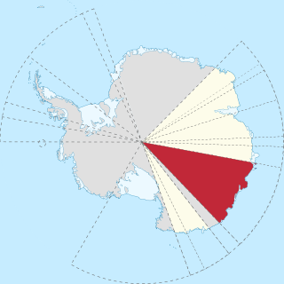
Adélie Land is a claimed territory on the continent of Antarctica. It stretches from a portion of the Southern Ocean coastline all the way inland to the South Pole. France has administered it as one of five districts of the French Southern and Antarctic Lands since 1955 and applied the Antarctic Treaty System rules since 1961. Article 4 deals with territorial claims, and although it does not renounce or diminish any preexisting claims to sovereignty, it also does not prejudice the position of Contracting Parties in their recognition or non-recognition of territorial sovereignty. France has had a permanent station in Adélie Land since April 9, 1950. The current Dumont d'Urville Station has a winter population around 25, but this goes up to about 78 during the Antarctic summer. A species of penguin, the Adélie penguin, is named after it.
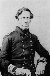
Charles Wilkes was an American naval officer, ship's captain, and explorer. He led the United States Exploring Expedition, 1838–1842. His behavior led to two convictions by court-martial, one stemming from the massacre of almost 80 Fijians on Malolo in 1840.
The Phoenix Islands, or Rawaki, are a group of eight atolls and two submerged coral reefs that lie east of the Gilbert Islands and west of the Line Islands in the central Pacific Ocean, north of Samoa. They are part of the Republic of Kiribati. Their combined land area is 28 square kilometres (11 sq mi). The only island of any commercial importance is Canton Island. The other islands are Enderbury, Rawaki, Manra, Birnie, McKean, Nikumaroro, and Orona.
Wilkes Land is a large district of land in eastern Antarctica, formally claimed by Australia as part of the Australian Antarctic Territory, though the validity of this claim has been placed for the period of the operation of the Antarctic Treaty, to which Australia is a signatory.
Vincennes Bay is a large V-shaped bay, 105 km (65 mi) wide at its entrance between Cape Nutt and Cape Folger in Antarctica, marked by several large, steep glaciers near its head, lying along Knox and Budd Coasts. It was photographed from the air by US Navy Operation Highjump in 1946–47. The bay was entered in January 1948 by US Navy Operation Windmill icebreakers Burton Island and stations in the Windmill Islands in the NE portion of the bay. Named by the US-ACAN for the sloop of war USS Vincennes, flagship of the USEE under Wilkes, from which a series of coastal landfalls along Wilkes Land were discovered and plotted during January–February 1840. Wilkes' chart suggests a possible coastal recession corresponding closely with the longitudinal limits for Vincennes Bay, although pack ice conditions prevented close reconnaissance by the USEE of the coast in this immediate area.

The United States Exploring Expedition of 1838–1842 was an exploring and surveying expedition of the Pacific Ocean and surrounding lands conducted by the United States. The original appointed commanding officer was Commodore Thomas ap Catesby Jones. Funding for the original expedition was requested by President John Quincy Adams in 1828, however, Congress would not implement funding until eight years later. In May 1836, the oceanic exploration voyage was finally authorized by Congress and created by President Andrew Jackson.

Shackleton Ice Shelf is an extensive ice shelf fronting the coast of East Antarctica from 95° E to 105° E. It extends for an along-shore distance of about 384 kilometres (239 mi), projecting seaward about 145 kilometres (90 mi) in the western portion and 64 kilometres (40 mi) in the east. It occupies an area of 33,820 square kilometres (13,058 sq mi). It is part of Mawson Sea and separates the Queen Mary Coast to the west from the Knox Coast of Wilkes Land to the east.

Franklin Island is an island 13 kilometres (7 nmi) long, lying in the Ross Sea about 130 kilometres (80 mi) east of Cape Hickey, Victoria Land. It was discovered on January 27, 1841 by James Clark Ross, and named for Sir John Franklin, the noted Arctic explorer, who as Governor of Van Diemen's Land (Tasmania) had royally entertained the expedition on its way south at Hobart in 1840. Though located just 80 kilometres (50 mi) north of Beaufort Island and appearing at first glance to be part of the same group, it is not usually considered to be part of the Ross Archipelago. The island is the eroded remnant of a shield volcano that formed 4.8 +/- 2.0 million years ago, the vent of which is now submerged off the east coast. The island hosts a breeding colony of Adélie penguins.

Knox Coast, part of Wilkes Land, is that portion of the coast of Antarctica lying between Cape Hordern, at 100°31′E, and the Hatch Islands, at 109°16′E.
Cape Folger is an ice-covered cape forming the east side of the entrance to Vincennes Bay on the Budd Coast of Antarctica. The position of Cape Folger correlates closely with the west end of Charles Wilkes' "Budd's High Land", as charted as a coastal landfall by the United States Exploring Expedition in 1840. The cape was mapped from aerial photographs taken by U.S. Navy Operation Highjump, 1946–47, and was named by the Advisory Committee on Antarctic Names for Commander Edward C. Folger, Jr., U.S. Navy, commander of the icebreaker Edisto which assisted Operation Windmill parties in establishing astronomical control stations in the Windmill Islands, close southwest in Vincennes Bay.

Budd Coast, part of Wilkes Land, is that portion of the coast of Antarctica lying between the Hatch Islands, at 109°16'E, and Cape Waldron, at 115°33'E. It was discovered in February 1840 by the U.S. Exploring Expedition (1838–42) under the leadership of Lieutenant Charles Wilkes, and named by Wilkes for Thomas A. Budd, Acting Master of the sloop Peacock, one of the ships used on the expedition. A portion of the Puget Sound, Budd Inlet, is also named for Thomas Budd.

Sabrina Coast is that portion of the coast of Wilkes Land, Antarctica, lying between Cape Waldron, at 115° 33' E, and Cape Southard, at 122° 05' E. John Balleny has long been credited with having seen land in March 1839 at about 117° E.
Cape Morse is a low, ice-covered cape which marks the east side of the entrance to Porpoise Bay and forms the division between Banzare Coast and Clarie Coast in Wilkes Land, Antarctica. It was delineated from air photos taken by U.S. Navy Operation Highjump in 1946–47, and was named by the Advisory Committee on Antarctic Names for William H. Morse, purser's steward on the brig Porpoise of the United States Exploring Expedition (1838–42) under Charles Wilkes.
Porpoise Bay is an ice-filled embayment about 90 miles (140 km) wide indenting the coast of Antarctica between Cape Goodenough and Cape Morse. The United States Exploring Expedition (1838–42) under Charles Wilkes applied the name "Porpoise Bay", after the USEE brig "Porpoise", to a large bay at about 66°S, 130°E. US-ACAN's identification of Porpoise Bay is based on the correlation of Wilkes' chart (1840) with G.D. Blodgett's reconnaissance map (1955) compiled from air photos taken by USN Operation Highjump (1946–47). The name has been applied to the large embayment lying close southwest in keeping with Wilkes' original naming.
George V Coast is that portion of the coast of Antarctica lying between Point Alden, at 148°2′E, and Cape Hudson, at 153°45′E.

Underwood Glacier is a channel glacier in Wilkes Land, Antarctica about 15 nautical miles long, flowing to the Antarctic coast between Reist Rocks and Cape Nutt. It was mapped in 1955 by G. D. Blodgett from aerial photographs taken by U.S. Navy Operation Highjump in 1947 and named by Advisory Committee on Antarctic Names (US-ACAN) after Lieutenant Thomas Joseph Underwood, Jr., USMC, who served on the sloop Vincennes of the United States Exploring Expedition (1838–42) under Lieutenant Charles Wilkes.

Clark Peninsula is a rocky peninsula, about 3 km (2 mi) long and wide, lying 5 km (3 mi) north-east of Australia's Casey Station at the north side of Newcomb Bay on the Budd Coast of Wilkes Land in Antarctica.
Cape Carr is a prominent, ice-covered cape, lying 15 nautical miles (30 km) northeast of Cape Morse.
Cape Keltie is an ice-covered cape on the Clarie Coast of Antarctica, 11 nautical miles (20 km) west of Cape Cesney. It was discovered from the Aurora by the Australasian Antarctic Expedition (1911–14) under Douglas Mawson, and roughly charted at a distance of about 10 nautical miles (19 km) as lying in 66°5′S 133°0′E. It was named by Mawson for Sir John Scott Keltie, Secretary of the Royal Geographical Society, 1892–1915. The identification of this feature is based upon the G.D. Blodgett map of 1955, compiled from aerial photos taken by U.S. Navy Operation Highjump (1946–47).

Cadwalader Ringgold was an officer in the United States Navy who served in the United States Exploring Expedition, later headed an expedition to the Northwest and, after initially retiring, returned to service during the Civil War.
