
The Holston River is a 136-mile (219 km) river that flows from Kingsport, Tennessee, to Knoxville, Tennessee. Along with its three major forks, it comprises a major river system that drains much of northeastern Tennessee, southwestern Virginia, and northwestern North Carolina. The Holston's confluence with the French Broad River at Knoxville marks the beginning of the Tennessee River.

Sleepy Creek is a 44.0-mile-long (70.8 km) tributary of the Potomac River in the United States, belonging to the Chesapeake Bay's watershed. The stream rises in Frederick County, Virginia, and flows through Morgan County, West Virginia before joining the Potomac near the community of Sleepy Creek.
Rocky Gap is an unincorporated community that is located in Bland County in the U.S. state of Virginia. In the year of 2016, there was an estimate that there were a total of 511 people living in Rocky Gap. Rocky Gap has one zip code (24366).
Clear Fork may refer to a location in the United States:

Slab Fork is an unincorporated community in Raleigh County, West Virginia, United States with a population of 202. Slab Fork is located along a stream of the same name and West Virginia Route 54. The ZIP code for Slab Fork is 25920.

Five Forks is an unincorporated community in Fairfax County, Virginia, United States. Originally, Five Forks was a small town located at the "forks" of Old Keene Mill Road and Lee Chapel Road. Today, the Five Forks area is almost exclusively located within the unincorporated community of Burke. Burke Town Plaza lies on the northeastern corner of the forks.

Clear Fork is an unincorporated community in Wyoming County, West Virginia, United States, along the Clear Fork.
Beards Fork is a census-designated place (CDP) and coal town in Fayette County, West Virginia, United States that was founded as a coal town. As of the 2010 census, its population was 199.
Lillydale is an unincorporated community in Wyoming County, West Virginia, United States. Lillydale is located on West Virginia Route 971 along the Clear Fork, 2.5 miles (4.0 km) southwest of Oceana.

Artie is an unincorporated community in Raleigh County, West Virginia, United States. Artie is 5.5 miles (8.9 km) west-northwest of Pax. Artie had a post office, which opened on October 5, 1903, and closed on February 1, 1997.

Dry Fork is an unincorporated community located in Bland County, Virginia, United States.
Clear Fork Junction is an unincorporated community in McDowell County, West Virginia.
Lillyhaven is an unincorporated community in Wyoming County, West Virginia, United States, along the Clear Fork.

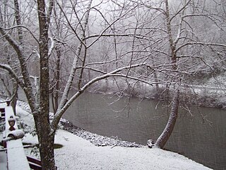
The Clear Fork is a tributary of the Guyandotte River, 29 miles (47 km) long, in southern West Virginia in the United States. Via the Guyandotte and Ohio rivers, it is part of the watershed of the Mississippi River, draining an area of 129 square miles (330 km2) in a rural area on the unglaciated portion of the Allegheny Plateau. The Clear Fork flows for its entire length in Wyoming County; its tributary the Laurel Fork also drains a small area of western Raleigh County.
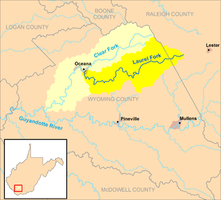
The Laurel Fork is a tributary of the Clear Fork, 23.5 miles (37.8 km) long, in southern West Virginia in the United States. Via the Clear Fork and the Guyandotte and Ohio rivers, it is part of the watershed of the Mississippi River, draining an area of 56.4 square miles (146 km2) in a rural area on the unglaciated portion of the Allegheny Plateau.
Toney Fork is an unincorporated community in Wyoming County, West Virginia, United States. Toney Fork is located on West Virginia Route 85 at the confluence of the Clear Fork and the Toney Fork, 2 miles (3.2 km) northeast of Oceana.
Sun Hill is an unincorporated community in Wyoming County, West Virginia, United States. Sun Hill is located on the Clear Fork and County Route 6 6.4 miles (10.3 km) southwest of Oceana.

The Laurel Fork is a 15.7-mile-long (25.3 km) stream in Virginia and West Virginia, United States. The stream flows north from Highland County, Virginia, where its source and the majority of its length is located, to its mouth in Pendleton County, West Virginia. Laurel Fork is a tributary to the North Fork South Branch Potomac River, making it a part of the Potomac River watershed. The area surrounding Laurel Fork is home to several plant and animal species found nowhere else in Virginia, and is a prime example of a northern boreal forest in the state.


