Clear Lake, Iowa

Last updated

Clear Lake, Iowa
City
Clear lake iowa.jpg
Historic Downtown Clear Lake
Cerro Gordo County Iowa Incorporated and Unincorporated areas Clear Lake Highlighted.svg
Location of Clear Lake, Iowa
Coordinates: 43°8′11″N93°22′48″W / 43.13639°N 93.38000°W / 43.13639; -93.38000
CountryUS
State Flag of Iowa.svg  Iowa
County Cerro Gordo
Area
[1]
  Total13.37 sq mi (34.63 km2)
  Land10.78 sq mi (27.92 km2)
  Water2.59 sq mi (6.71 km2)
Elevation
1,237 ft (377 m)
Population
 (2020)
  Total7,687
  Density713.15/sq mi (275.34/km2)
Time zone UTC-6 (Central (CST))
  Summer (DST) UTC-5 (CDT)
ZIP code
50428
Area code 641
FIPS code 19-14025
GNIS feature ID0455465
Website www.cityofclearlake.com

Clear Lake is a city in Cerro Gordo County, Iowa, United States. The population was 7,687 at the 2020 census. [2] The city is named for the large lake on which it is located. It is the home of a number of marinas, state parks and tourism-related businesses. Clear Lake is also a major stop on Interstate 35 with many restaurants, hotels and truck stops.

Contents

History

Clear Lake water tower and shoreline. FI0005243.jpg
Clear Lake water tower and shoreline.

The region around the lake that would later be called Clear Lake was a summer home to the Dakota and Winnebago American Indians. During a land survey of northern Iowa done in 1832 by Nathan Boone, the son of the famous explorer Daniel Boone, a map was made showing the lake and other bodies of water in the area. [3]

In 1851, Joseph Hewitt and James Dickirson brought their families to camp on the east side of Clear Lake, soon building a cabin, and began a friendship with the Winnebago natives. By 1853, many more white settlers had also came to settle in the area. By the year 1855, the first Clear Lake school was built as well as the first steam saw mill. In that year a hotel was built by James Crow. [3]

By 1870, the town had 775 residents and by 1871 the streets were graded and sidewalks were made of raised boards, sure signs of a thriving new city. [3] [4] The city of Clear Lake was incorporated on May 26, 1871. The first bandstand in Clear Lake was built in 1877 at the City Park. The town continued to grow and built its first library in 1889. In 1909, Bayside Amusement park opened for the first time. The first North Iowa Band Festival was organized by John Kopecky, among others, in 1932. [3]

In 1933, the Surf Ballroom opened up on the site of the old Tom Tom ballroom that had been destroyed by fire. The opening dance night saw approximately 700 couples attend. In 1947, the Surf Ballroom burned down; a new Surf Ballroom was built across the street the following year. The Bayside Amusement park closed down in 1958. [3]

The Day the Music Died

Monument at crash site HollyMonument.jpg
Monument at crash site

In the early hours of February 3, 1959, a Beechcraft Bonanza aircraft carrying Buddy Holly, Ritchie Valens, and The Big Bopper, who had been performing at the Surf Ballroom in Clear Lake, took off from the local runway in nearby Mason City, on its way to the next show in Moorhead, Minnesota.

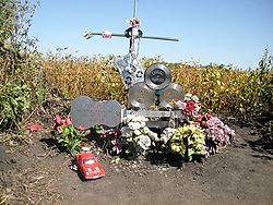
The plane crashed soon after take off, killing everyone onboard. The event was later eulogized by folk singer Don McLean in his 1971 song "American Pie", which led to the crash being nicknamed "The Day the Music Died".

In June 1988, around 600 people gathered to witness the dedication of the monument to the three musicians. Clear Lake also renamed Second Place North to "Buddy Holly Place". [3]

Geography

Clear Lake is located at 43°8′11″N93°22′48″W / 43.13639°N 93.38000°W / 43.13639; -93.38000 (43.136479, −93.379927). [5]

According to the United States Census Bureau, the city has a total area of 13.44 square miles (34.81 km2), of which 10.80 square miles (27.97 km2) is land and 2.64 square miles (6.84 km2) is water. [6]

Climate

Clear Lake, Iowa has a hot/warm summer humid continental climate (Dfa).

Climate data for Mason City Municipal Airport
MonthJanFebMarAprMayJunJulAugSepOctNovDecYear
Record high °F (°C)62
(17)
66
(19)
84
(29)
93
(34)
99
(37)
103
(39)
104
(40)
101
(38)
99
(37)
95
(35)
79
(26)
67
(19)
104
(40)
Mean daily maximum °F (°C)25
(−4)
29
(−2)
42
(6)
58
(14)
70
(21)
80
(27)
83
(28)
81
(27)
73
(23)
60
(16)
43
(6)
28
(−2)
56
(13)
Daily mean °F (°C)16
(−9)
21
(−6)
33
(1)
47
(8)
58
(14)
68
(20)
72
(22)
69
(21)
61
(16)
48
(9)
34
(1)
20
(−7)
46
(8)
Mean daily minimum °F (°C)7
(−14)
12
(−11)
24
(−4)
35
(2)
47
(8)
57
(14)
61
(16)
58
(14)
49
(9)
37
(3)
24
(−4)
11
(−12)
35
(2)
Record low °F (°C)−31
(−35)
−32
(−36)
−28
(−33)
6
(−14)
22
(−6)
36
(2)
42
(6)
35
(2)
24
(−4)
12
(−11)
−16
(−27)
−26
(−32)
−32
(−36)
Average precipitation inches (mm)0.82
(21)
1.00
(25)
2.23
(57)
3.75
(95)
4.68
(119)
5.14
(131)
4.70
(119)
4.04
(103)
3.27
(83)
2.45
(62)
1.88
(48)
1.24
(31)
35.20
(894)
Average snowfall inches (cm)10.8
(27)
7.7
(20)
6.0
(15)
2.7
(6.9)
0.0
(0.0)
0.0
(0.0)
0.0
(0.0)
0.0
(0.0)
0.0
(0.0)
0.4
(1.0)
4.3
(11)
9.3
(24)
41.2
(105)
Average precipitation days (≥ 0.01 in.)7.57.29.211.112.111.29.79.58.78.88.08.5111.5
Average snowy days (≥ 0.1 in.)6.85.13.51.7000000.53.47.228.2
Source: National Centers for Environmental Information [7] [8]

Demographics

Historical population
CensusPop.Note
1870 775
1880 1,09541.3%
1890 1,1303.2%
1900 1,70651.0%
1910 2,01418.1%
1920 2,80439.2%
1930 3,0669.3%
1940 3,76422.8%
1950 4,97732.2%
1960 6,15823.7%
1970 6,4304.4%
1980 7,45816.0%
1990 8,1839.7%
2000 8,161−0.3%
2010 7,777−4.7%
2020 7,687−1.2%
Iowa Data Center [4] [2]
The population of Clear Lake, Iowa from US census data Clear LakeIowaPopPlot.png
The population of Clear Lake, Iowa from US census data

Clear Lake is part of the Mason City Micropolitan Statistical Area.

2010 census

As of the census [9] of 2010, there were 7,777 people, 3,507 households, and 2,087 families residing in the city. The population density was 720.1 inhabitants per square mile (278.0/km2). There were 4,423 housing units at an average density of 409.5 per square mile (158.1/km2). The racial makeup of the city was 96.3% White, 0.5% African American, 0.1% Native American, 1.2% Asian, 0.5% from other races, and 1.4% from two or more races. Hispanic or Latino of any race were 2.2% of the population.

There were 3,507 households, of which 25.0% had children under the age of 18 living with them, 47.9% were married couples living together, 8.6% had a female householder with no husband present, 3.0% had a male householder with no wife present, and 40.5% were non-families. 35.3% of all households were made up of individuals, and 16% had someone living alone who was 65 years of age or older. The average household size was 2.16 and the average family size was 2.78.

The median age in the city was 46.3 years. 20.7% of residents were under the age of 18; 6.2% were between the ages of 18 and 24; 21.2% were from 25 to 44; 31.9% were from 45 to 64; and 20.2% were 65 years of age or older. The gender makeup of the city was 48.2% male and 51.8% female.

2000 census

As of the census [10] of 2000, there were 8,161 people, 3,461 households, and 2,239 families residing in the city. The population density was 782.4 inhabitants per square mile (302.1/km2). There were 4,156 housing units at an average density of 398.4 per square mile (153.8/km2). The racial makeup of the city was 96.99% White, 0.27% African American, 0.13% Native American, 0.92% Asian, 0.06% Pacific Islander, 0.75% from other races, and 0.88% from two or more races. Hispanic or Latino of any race were 1.86% of the population.

There were 3,461 households, out of which 28.4% had children under the age of 18 living with them, 52.4% were married couples living together, 9.6% had a female householder with no husband present, and 35.3% were non-families. 31.1% of all households were made up of individuals, and 12.9% had someone living alone who was 65 years of age or older. The average household size was 2.28 and the average family size was 2.86.

Age spread:23.0% under the age of 18, 7.6% from 18 to 24, 26.7% from 25 to 44, 25.1% from 45 to 64, and 17.7% who were 65 years of age or older. The median age was 41 years. For every 100 females, there were 91.2 males. For every 100 females age 18 and over, there were 87.4 males.

The median income for a household in the city was $35,097, and the median income for a family was $45,589. Males had a median income of $30,266 versus $21,356 for females. The per capita income for the city was $20,213. About 5.0% of families and 7.6% of the population were below the poverty line, including 8.0% of those under age 18 and 5.7% of those age 65 or over.

Clear Lake Fire Museum, 2013 Clear Lake Fire Museum.JPG
Clear Lake Fire Museum, 2013

Arts and culture

Downtown Clear Lake rowhouses Clear Lake Rowhouses.jpg
Downtown Clear Lake rowhouses

Education

There are three schools in the local public school district, Clear Lake Community School District. Clear Creek Elementary School hosts preschool, [13] kindergarten, and grades 1–5; Clear Lake Middle School hosts grades 6–8; and Clear Lake High School hosts grades 9–12. [14] Lakeside Alternative, an alternative school program, is run jointly with the Garner–Hayfield–Ventura Community School District in neighboring Ventura, Iowa. [15]

Clear Lake Classical, a preK–8 Classical Christian school, [16] is the only private school in the city.

Infrastructure

Transportation

Clear Lake is located along Interstate 35 approximately halfway between the Twin Cities and Des Moines, Iowa. U.S. Highway 18 runs east–west through the northern side of the city until it meets Interstate 35; at this interchange, Iowa Highway 122 begins and continues to the east. U.S. 18 proper continues to the south, overlapping an approximately 3.5-mile stretch of Interstate 35 and Iowa Highway 27 (part of the Avenue of the Saints). Just south of the city, U.S. 18 and Iowa 27 break from Interstate 35 and continue to the east. [17]

The North Iowa Area Council of Governments operates Region 2 Transit, which provides city and regional demand responsive public bus transit. [18] Jefferson Lines, a private intercity bus service, maintains a stop in Clear Lake with service to locations throughout the Midwest. [19]

Mason City Municipal Airport is located immediately to the east of Clear Lake. [20]

Two freight rail lines run through the city. Canadian Pacific Railway operates a line parallel to U.S. 18, which stops at a minor grain facility; trackage rights are given to the Iowa Northern Railway. Progressive Rail maintains the Iowa Traction Railway, a shortline railroad which runs between Clear Lake and Mason City. [21]

Utilities

The city's electric power and natural gas utilities are provided by Alliant Energy. [22] Since 2004, Alliant Energy has operated a natural gas—fired electricity generation plant southeast of the city. [23]

Sewage treatment is provided by the Clear Lake Sanitary District, a local government entity separate from the city government. Wastewater travels through pump stations within the city before being routed to a treatment plant to the south. There, it is filtered, processed through a sequencing batch reactor, and disinfected with ultraviolet light. Some of the resulting treated effluent is routed to the nearby Alliant Energy plant for cooling purposes. [24]

Telephone, cable television, and internet services are provided by local provider CL Tel [25] and Mediacom. [26]

Water supply services are provided by the city. The city's water is drawn from shallow wells in the Cedar Valley Formation. [27]

Waste collection services are also provided by the city and operated by local company Absolute Waste Removal. [28] Further processing is performed at the Landfill of North Iowa to the east. [29]

Health care

MercyOne Medical Center North Iowa [30] in neighboring Mason City is the nearest hospital. Both MercyOne [31] and Iowa Specialty Hospital [32] operate clinics within the city.

In September 2020, construction began on a wellness center near Clear Lake High School for joint use by Clear Lake Community School District and the community. [33]

Notable people

See also

Related Research Articles

<span class="mw-page-title-main">Poweshiek County, Iowa</span> County in Iowa, United States

Poweshiek County is a county in the southeastern part of the U.S. state of Iowa. As of the 2020 census, the population was 18,662. The county seat is Montezuma. The county is named for the chief of the Fox tribe who signed the treaty ending the Black Hawk War. It lies along Interstate 80 between Des Moines and Iowa City. Poweshiek County's largest city is Grinnell.

<span class="mw-page-title-main">Wright County, Iowa</span> County in Iowa, United States

Wright County is a county in the U.S. state of Iowa. As of the 2020 census, the population was 12,943. The county seat is Clarion. The county organization became effective in January 1851, and is believed to be named either after Silas Wright, a governor of New York, or Joseph Albert Wright, a governor of Indiana.

<span class="mw-page-title-main">Pottawattamie County, Iowa</span> County in Iowa, United States

Pottawattamie County is a county located in the U.S. state of Iowa. At the 2020 census, the population was 93,667, making it the tenth-most populous county in Iowa. The county takes its name from the Potawatomi Native American tribe. The county seat is Council Bluffs.

<span class="mw-page-title-main">Hamilton County, Iowa</span> County in Iowa, United States

Hamilton County is a county located in the U.S. state of Iowa. As of the 2020 census, the population was 15,039. The county seat is Webster City. The county was named to honor William W. Hamilton, a President of the Iowa State Senate.

<span class="mw-page-title-main">Cerro Gordo County, Iowa</span> County in Iowa, United States

Cerro Gordo County is a county located in the U.S. state of Iowa. As of the 2020 census, the population was 43,127. Its county seat is Mason City. The county is named for the Battle of Cerro Gordo, which took place during the Mexican–American War.

<span class="mw-page-title-main">Centerville, Iowa</span> City in Iowa, United States

Centerville is a city in and the county seat of Appanoose County, Iowa, United States. The population was 5,412 in the 2020 census, a decline from 5,924 in 2000. After the turn of the 20th century Centerville's coal mining industry attracted European immigrants from Sweden, Italy, Croatia, and Albania. Centerville is also home of the largest town square in the state of Iowa.

<span class="mw-page-title-main">Mason City, Iowa</span> City in Iowa, United States

Mason City is a city and the county seat of Cerro Gordo County, Iowa, United States. The population was 27,338 in the 2020 census. Mason City is known for its musical heritage, high concentrations of renowned Prairie School style architecture, and a close connection with nearby Clear Lake.

<span class="mw-page-title-main">Ventura, Iowa</span> City in Iowa, United States

Ventura is a city in Cerro Gordo County, Iowa, United States. The population was 711 at the time of the 2020 census. It is part of the Mason City Micropolitan Statistical Area. Ventura is located on the northeastern basin of Clear Lake, making it an area with many lakeside areas.

<span class="mw-page-title-main">Osceola, Iowa</span> City in Iowa, United States

Osceola is a city in Clarke County, Iowa, United States. The population was 5,160 at the time of the 2020 census. It is the county seat of Clarke County.

<span class="mw-page-title-main">Urbandale, Iowa</span> City in Iowa, United States

Urbandale is a city in Polk and Dallas counties, Iowa, United States. As of the 2020 U.S. Census, the city population was 45,580. It is part of the Des Moines–West Des Moines Metropolitan Statistical Area.

<span class="mw-page-title-main">Arnolds Park, Iowa</span> City in Iowa, United States

Arnolds Park is a city in Dickinson County, Iowa, United States. The population was 1,110 in the 2020 census, a decline from the 1,162 population in the 2000 census.

<span class="mw-page-title-main">West Okoboji, Iowa</span> City in Iowa, United States

West Okoboji is a city in Dickinson County, Iowa, United States. The population was 308 at the time of the 2020 census. The city is located on West Okoboji Lake, from which it takes its name. It is part of the Iowa Great Lakes region.

<span class="mw-page-title-main">Hampton, Iowa</span> Town in Iowa, United States

Hampton is a town and county seat of Franklin County, Iowa, United States. The population was 4,337 at the time of the 2020 census.

<span class="mw-page-title-main">Coralville, Iowa</span> City in Iowa, United States

Coralville is a city in Johnson County, Iowa, United States. It is a suburb of Iowa City and part of the Iowa City Metropolitan Statistical Area. The population was 22,318 at the 2020 census.

<span class="mw-page-title-main">Emmetsburg, Iowa</span> City in Iowa, United States

Emmetsburg is a city in Palo Alto County, Iowa, United States. The population was 3,706 at the time of the 2020 census. It is the county seat of Palo Alto County. Emmetsburg is located around the southern bay of Five Island Lake.

<span class="mw-page-title-main">Montezuma, Iowa</span> City in Iowa, United States

Montezuma is a city in Poweshiek County, Iowa, United States. The population was 1,442 at the time of the 2020 census. It is the county seat of Poweshiek County.

<span class="mw-page-title-main">Mount Ayr, Iowa</span> City in Iowa, United States

Mount Ayr is a city in Ringgold County, Iowa, United States. The population was 1,988 at the time of the 2020 census. It is the county seat of Ringgold County. Mount Ayr is a rural community in southwestern Iowa, 22 miles west of Interstate 35 on State Highway 2. Mount Ayr was founded in 1875 and the community was named in honor of poet Robert Burns’ birthplace in Ayr, Scotland. The “mount” was added to indicate its location on the highest point of land in the area.

<span class="mw-page-title-main">Story City, Iowa</span> City in Iowa, United States

Story City is a city in Story County, Iowa. It is located within the Ames, Iowa Metropolitan Statistical Area which envelops the entirety of Story County and combined with the Boone, Iowa Micropolitan Statistical Area makes up the larger Ames-Boone, Iowa Combined Statistical Area. The population was 3,352 in the 2020 census, a slight increase from 3,228 in 2000.

<span class="mw-page-title-main">Manly, Iowa</span> City in Iowa, United States

Manly is a city in Worth County, Iowa, United States, whose population was 1,256 at the time of the 2020 census. It is part of the Mason City Micropolitan Statistical Area.

<span class="mw-page-title-main">Manvel, Texas</span> City in Texas, United States

Manvel is a city in Brazoria County, Texas, United States. As of July 2022, the population was 14,803, up from 9,908 at the 2020 census.

References

  1. "2020 U.S. Gazetteer Files". United States Census Bureau. Retrieved March 16, 2022.
  2. 1 2 "2020 Census State Redistricting Data". census.gov. United states Census Bureau. Retrieved August 12, 2021.
  3. 1 2 3 4 5 6 "Clear Lake Historical Society". Historical events. Retrieved December 1, 2010.
  4. 1 2 "Iowa Data Center" (PDF). Clear Lake. Retrieved December 1, 2010.
  5. "US Gazetteer files: 2010, 2000, and 1990". United States Census Bureau. February 12, 2011. Retrieved April 23, 2011.
  6. "US Gazetteer files 2010". United States Census Bureau. Archived from the original on June 1, 2012. Retrieved May 11, 2012.
  7. "Mason City Municipal Airport climate normals". National Centers for Environmental Information. Retrieved September 30, 2019.
  8. "Mason City Municipal Airport daily GHCN data". National Centers for Environmental Information. Retrieved September 30, 2019.
  9. "U.S. Census website". United States Census Bureau . Retrieved May 11, 2012.
  10. "U.S. Census website". United States Census Bureau . Retrieved January 31, 2008.
  11. Lady of the Lake Cruise
  12. 1 2 3 Attractions Archived June 9, 2007, at the Wayback Machine
  13. McNett, Jared (April 11, 2019). "New preschool in Clear Lake scheduled to open in Fall 2019". Mason City Globe Gazette. Retrieved September 30, 2019.
  14. "Schools". Clear Lake Community School District. Retrieved September 30, 2019.
  15. "Lakeside Alternative" . Retrieved September 30, 2019.
  16. "About". Clear Lake Classical.
  17. Iowa Department of Transportation. Highway and Street Map of Clear Lake, Iowa (PDF) (Map). Clear Lake Iowa: Iowa Department of Transportation. Retrieved October 6, 2019.
  18. "Region 2 Transit". Iowa Department of Transportation. Retrieved October 6, 2019.
  19. Jefferson Lines. "Buses to Iowa" . Retrieved October 6, 2019.
  20. Mason City Municipal Airport. "Home" . Retrieved October 6, 2019.
  21. Iowa Department of Transportation. Iowa Grain Facilities Rail Map (PDF) (Map). Iowa: Iowa Department of Transportation. Retrieved October 6, 2019.
  22. Alliant Energy. "Communities we serve" . Retrieved September 7, 2021.
  23. Horgen, Jan (May 19, 2004). "Power starts flowing from Emery Generating Plant". Globe Gazette. Retrieved September 7, 2021.
  24. Clear Lake Sanitary District. "Treatment" . Retrieved September 7, 2021.
  25. CL Tel. "Here for You!" . Retrieved September 7, 2021.
  26. City of Clear Lake. "Utility Billing Department" . Retrieved September 7, 2021.
  27. City of Clear Lake. "Water Department" . Retrieved September 7, 2021.
  28. Absolute Waste Removal. "Absolute Waste Removal" . Retrieved September 7, 2021.
  29. Landfill of North Iowa. "About" . Retrieved September 7, 2021.
  30. MercyOne. "About Us" . Retrieved September 9, 2021.
  31. MercyOne. "MercyOne Clear Lake Family Medicine" . Retrieved September 9, 2021.
  32. Iowa Specialty Hospital. "Gabrielson Clinic - Clear Lake" . Retrieved September 9, 2021.
  33. Jirgens, Alex (September 16, 2020). "Ground officially broken on Clear Lake's shared school district-community wellness center". KIMT. Retrieved September 9, 2021.
  34. Blodgett, Todd (December 28, 2021). "Todd Blodgett's pro-Mohawk comments ruffle Globe-Gazette editor's fur, is fired from nearly-kaput newspaper for second time since 2017". NIT Publisher. North Iowa Today. Retrieved January 3, 2023.
  35. "Richard Hayward Bio". Little Feat. Retrieved October 1, 2019.
  36. "KAYNOR, William Kirk". Biographical Directory of the United States Congress. Retrieved December 1, 2010.
  37. "Our Founder". McGraw Foundation. Retrieved October 1, 2019.