Clearview, Ontario

Last updated

Clearview
Township of Clearview
Clearview ON.JPG
Motto(s): 
Beautiful Landscapes, Friendly People
Simcoe locator map 2021.svg
Red pog.svg
Clearview
Canada Southern Ontario location map 2.png
Red pog.svg
Clearview
Coordinates: 44°23′53″N80°04′27″W / 44.39806°N 80.07417°W / 44.39806; -80.07417 [1]
CountryFlag of Canada (Pantone).svg  Canada
Province Flag of Ontario.svg  Ontario
County Simcoe
EstablishedJanuary 1, 1994 (1994-01-01)
Government
  MayorDoug Measures
  MPs Terry Dowdall (C)
  MPPs Jim Wilson (PC)
Area
[2]
  Land557.10 km2 (215.10 sq mi)
Elevation
[3]
221 m (725 ft)
Population
 (2016) [4]
  Total14,151
  Density25.4/km2 (66/sq mi)
Time zone UTC-5 (Eastern Time Zone (EST))
  Summer (DST) UTC-4 (Eastern Time Zone (EDT))
Postal code FSA
L0M
Area code(s) 705, 249
Website www.clearview.ca

Clearview is a rural incorporated township in Simcoe County in Central Ontario, Canada, [1] west of Barrie and south of Collingwood and Wasaga Beach in Simcoe County.

Contents

History

Human occupation of the area is evident starting in as early as the Paleo-Indian period. [5] :419

Before the arrival of European settlers, the area of Clearview Township was part of the territory of the Petun, a confederation of Iroquoians who were closely related to the Huron and Neutral peoples. The Petun were ravaged by disease epidemics in the early 17th century and victim to raids by the Iroquois Confederacy (a part of the Beaver Wars), with much of their remaining population fleeing as refugees and vacating the territory. There are abundant archaeological remains in the township from the Petun period. [5] :1–2

Early settlement on the site of Stayner coincided with the construction of the Toronto, Simcoe and Huron Railway between 1851 and 1855. The community of Stayner, which was originally called Nottawasaga Station, developed into a significant agricultural and lumbering centre. [6] Stayner was incorporated as a village in 1872, [7] and as a Town in 1888. [8] The Village of Creemore was incorporated effective 20 November 1889. [9]

Before incorporation, New Lowell was the site of a timber plant owned by Jacques and Hay.

Clearview Township was established on January 1, 1994, when the Town of Stayner, the Village of Creemore and the Townships of Nottawasaga and Sunnidale were amalgamated. [10] The Townships of Nottawasaga and Sunnidale had been incorporated in 1851 [11] and 1858, [12] respectively.

Geography

The township comprises the communities of Avening, Batteaux, Brentwood, Cashtown Corners, Creemore, Dunedin, Duntroon, Glen Huron, Maple Valley, New Lowell, Nottawa, Pretty River Valley, Singhampton, Smithdale, Stayner, Sunnidale, Sunnidale Corners and Websterville.

It borders on the following municipalities:

Clearview (and Simcoe County in general) is part of Central Ontario as well as the Georgian Triangle. The climate in the area is classified as Humid Continental (Warm Summer Subtype).

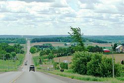
Located in the Great Lakes lowlands, it has fertile soil quite suitable for farming. As a result of the proximity to the Great Lakes it suffers from Lake Effect.
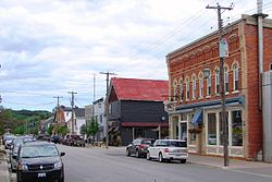
Creemore ON.JPG
Creemore
Stayner ON.JPG
Stayner

Demographics

In the 2021 Census of Population conducted by Statistics Canada, Clearview had a population of 14,814 living in 5,570 of its 6,296 total private dwellings, a change of 4.7% from its 2016 population of 14,151. With a land area of 556.37 km2 (214.82 sq mi), it had a population density of 26.6/km2 (69.0/sq mi) in 2021. [13]

Canada census – Clearview community profile
2021 2016 2011
Population14,814 (+4.7% from 2016)14,151 (+3.0% from 2011)13,734 (-2.5% from 2006)
Land area556.37 km2 (214.82 sq mi)557.10 km2 (215.10 sq mi)557.44 km2 (215.23 sq mi)
Population density26.6/km2 (69/sq mi)25.4/km2 (66/sq mi)24.6/km2 (64/sq mi)
Median age44.8 (M: 43.6, F: 45.6)45.3 (M: 44.4, F: 46.0)
Private dwellings6,296 (total)  5,570 (occupied)6,040 (total) 5,852 (total) 
Median household income$97,000$78,519
References: 2021 [14] 2016 [15] 2011 [16] earlier [17] [18]

Economy

As of 2006, compared to Ontario as a whole, Construction, Agriculture, and Manufacturing industries employ a greater than average percentage of the workforce (Business, Finance and Real Estate employ smaller than average). [19] The employment rate was 67.1% (62.8% for Ontario) and the unemployment rate was 4.5% (6.4% for Ontario). 40% of the workforce worked outside the municipality and 13% worked from home.

The well-known Creemore Springs Brewery is located in Creemore.

Health Canada medical marijuana licensed producers The Peace Naturals Project and Agripharm Corp. produces their medicinal Cannabis in Clearview Township.

The Stayner Sun is the township's newspaper of record. It has published continually since 1877. The newspaper is owned by Metroland Media Group.

Attractions

Creemore was one of the original claimants for the location of Ontario's smallest jailhouse. Its jailhouse, with dimensions at 4.5 metres by 6 metres, make it smaller than the other early claimants, Tweed, and Coboconk; however, others in Rodney, Port Dalhousie, Providence Bay, and Berens River are smaller. Today, the jail has been converted into a museum.

There are two arenas (Stayner, Creemore), three Baseball Parks (Nottawa, Stayner, with the largest being in New Lowell) and 3 Golf Courses (Duntroon Highlands, Batteaux Creek Golf Club, Mad River Golf and Country Club) in Clearview. The Bruce Trail runs along the Niagara Escarpment in the western part of the township, and there is a cross-country skiing centre in Duntroon. Devil's Glen Provincial Park, Nottawasaga Lookout and Noisy River Provincial Nature Reserves, and Nottawasaga Bluffs, New Lowell, and Carruthers Memorial Conservation Areas as well as the Mel McKean Memorial Park, Gowan Memorial Park, Ives Park, Kinsmen Participark, and Legion Park are all green spaces located within the township. The Stayner hay monster is located at Fernwood Farm & Market. It is a monster made of hay.

The Great Northern Exhibition is held annually in Clearview Township.

Government

The township is administered by a Town Council with one member from each of the seven (numbered) wards, a mayor and deputy-mayor.

The administration of the town is divided into the Departments of Finance, Planning and Development, Public Works, an Administration staff as well as the Public Library and Fire Department. [20] All the main administrative buildings of Clearview are located in Stayner.

The 2019 approved budget for the township was $28.98 million. [21]

Infrastructure

Transportation

Major roads in Clearview include Highway 26, County Road 124, (formerly Highway 24, and a part of Hurontario Street), County Road 42 (formerly a part of Airport Road), as well as other county roads such as 7, 9, 10, and 91. Despite its name, Collingwood Airport is also located in Clearview.

Clearview Public Transit is a small system that runs in the Clearview Township operating one route that connects in Wasaga Beach. The system started November 21, 2016, and is operated by Sinton-Landmark.

The Simcoe County LINX inter-community bus service's 2 Wasaga Beach to Barrie route has stops in Clearview at the Brentwood Community Centre in Brentwood and the Clearview Administration Centre in Stayner. [22]

Services

Clearview is served by Collingwood General And Marine Hospital in Collingwood. Policing services are provided by the Huronia West detachment of the OPP out of Wasaga Beach. Fire protection is provided by volunteer fire stations located throughout the township. [23]

Education

Clearview township is served by the Simcoe County District School Board (SCDSB), Simcoe Muskoka Catholic District School Board (SMCDS) and the French Catholic School Board Conseil scolaire catholique MonAvenir. A number of schools, although located in other municipalities (specifically Collingwood, Essa Township and Wasaga Beach), have catchment areas that extend into Clearview.

NameTypeLocationBoardMunicipality
Clearview Meadows Elementary SchoolPrimaryStaynerSCDSBClearview
Duntroon Central Public SchoolPrimaryDuntroonSCDSBClearview
New Lowell Central Public SchoolPrimaryNew LowellSCDSBClearview
Our Lady of Grace SchoolPrimaryAngusSMCDSEssa
Nottawa Elementary SchoolPrimaryNottawaSCDSBClearview
Nottawasaga & Creemore Public SchoolPrimaryCreemoreSCDSBClearview
Nottawasaga Pines Secondary SchoolSecondaryAngusSCDSBEssa
St. Mary's SchoolPrimaryCollingwoodSMCDSCollingwood
St. Noel ChabanelPrimaryWasaga BeachSMCDSWasaga Beach
Stayner Collegiate InstituteSecondaryStaynerSCDSBClearview
Collingwood Collegiate InstituteSecondaryCollingwoodSCDSBCollingwood
Our Lady of the Bay Catholic High School (previously Jean Vanier)SecondaryCollingwoodSMCDSCollingwood

While there is no post-secondary education in Clearview itself, the main campus of Georgian College is in nearby Barrie with a satellite campus in Collingwood nearby.

The Clearview Public Library maintains branches in Stayner, Creemore and New Lowell.

Notable people

See also

Related Research Articles

<span class="mw-page-title-main">Georgian Bay</span> Large bay of Lake Huron, Ontario, Canada

Georgian Bay is a large bay of Lake Huron, in the Laurentia bioregion. It is located entirely within the borders of Ontario, Canada. The main body of the bay lies east of the Bruce Peninsula and Manitoulin Island. To its northwest is the North Channel.

<span class="mw-page-title-main">Collingwood, Ontario</span> Town in Ontario, Canada

Collingwood is a town in Simcoe County, Ontario, Canada. It is situated on Nottawasaga Bay at the southern point of Georgian Bay. Collingwood is well known as a tourist destination, for its skiing in the winter, and limestone caves along the Niagara Escarpment in the summer.

<span class="mw-page-title-main">Simcoe County</span> County in Ontario, Canada

Simcoe County is located in the central portion of Southern Ontario, Canada. The county is just north of the Greater Toronto Area, stretching from the shores of Lake Simcoe in the east to Georgian Bay in the west. Simcoe County forms part of the Greater Golden Horseshoe area, a densely populated and industrialized region, centred on the Greater Toronto Area.

<span class="mw-page-title-main">Creemore</span> Place in Ontario, Canada

Creemore is a former village, now part of Clearview Township, located in Simcoe County, Ontario, Canada. It lies approximately 130 km (81 mi) north of Toronto, 40 minutes west of Barrie, and 20 minutes south of Collingwood and Georgian Bay. It sits on the eastern boundary of the Niagara Escarpment.

<span class="mw-page-title-main">Nottawasaga River</span> River in Ontario, Canada

The Nottawasaga River is a river in Simcoe County and Dufferin County in Central Ontario, Canada. It is part of the Great Lakes Basin, and is a tributary of Lake Huron. The river flows from the Orangeville Reservoir in the town of Orangeville, Dufferin County, through the Niagara Escarpment and the Minesing Wetlands, the latter a wetland of international significance, and empties into Nottawasaga Bay, an inlet of Georgian Bay on Lake Huron, at the town of Wasaga Beach, Simcoe County.

<span class="mw-page-title-main">Wasaga Beach</span> Town in Ontario, Canada

Wasaga Beach is a town in Simcoe County, Ontario, Canada. Situated along the longest freshwater beach in the world, it is a popular summer tourist destination. It is located along the southern end of Georgian Bay, approximately 150 km (93 mi) north of Toronto and about 40 km (25 mi) northwest of Barrie. To the west, Collingwood and The Blue Mountains also attract visitors much of the year. The town is situated along a very long sandy beach on Nottawasaga Bay in Georgian Bay and the winding Nottawasaga River. The beaches are part of the Wasaga Beach Provincial Park; the park area totals 168 hectares. Wasaga Beach has a year-round population of 24,862 as of 2021, but during the summer months the population increases with many seasonal residents.

<span class="mw-page-title-main">Springwater, Ontario</span> Township in Ontario, Canada

Springwater is a township in central Ontario, Canada, in Simcoe County, near Barrie. It is the county seat of Simcoe County.

<span class="mw-page-title-main">Simcoe North (federal electoral district)</span> Federal electoral district in Ontario, Canada

Simcoe North is a federal electoral district in central Ontario, Canada. It was established as a federal riding in 1867.

<span class="mw-page-title-main">Tiny, Ontario</span> Township in Ontario, Canada

Tiny, also known as Tiny Township, is a township in Simcoe County, south-central Ontario, Canada. The Township of Tiny can be found in the southern Georgian Bay region and is approximately 30 kilometres (19 mi) long or 410 square kilometres (160 sq mi).

<span class="mw-page-title-main">Simcoe—Grey (federal electoral district)</span> Federal electoral district in Ontario, Canada

Simcoe—Grey is a federal electoral district in Ontario, Canada, that has been represented in the House of Commons of Canada since 1997.

Grey—Simcoe was a federal electoral district represented in the House of Commons of Canada from 1968 to 1988. It was located in the province of Ontario. This riding was created in 1966 from parts of Grey North, Grey—Bruce and Simcoe East ridings.

Wellington—Grey—Dufferin—Simcoe was a federal electoral district represented in the House of Commons of Canada from 1988 to 1997. It was located in the province of Ontario. This riding was created in 1987 from parts of Bruce—Grey, Grey—Simcoe and Wellington—Dufferin—Simcoe ridings.

<span class="mw-page-title-main">Nottawasaga Bay</span>

Nottawasaga Bay is a sub-bay within Georgian Bay in Southern Ontario, Canada located at the southernmost end of the main bay. The communities located on Nottawasaga Bay are Meaford, The Blue Mountains, Collingwood, Wasaga Beach and Tiny.

Edenvale is an unincorporated place in Springwater Township, Simcoe County, Ontario, Canada.

<span class="mw-page-title-main">Simcoe—Grey (provincial electoral district)</span> Provincial electoral district in Ontario, Canada

Simcoe—Grey is a provincial electoral district in Ontario, Canada, that has been represented in the Legislative Assembly of Ontario since 1999.

Clearview Public Library is a public library serving the residents of the Township of Clearview, Simcoe County, Ontario, Canada, and through contracts to the residents of the adjoining townships of Adjala–Tosorontio, Simcoe County, and Mulmur, Dufferin County. Library branches are located in the communities of Stayner, Creemore and New Lowell. A drop box is located in the community of Nottawa.

King's Highway 92, also known as Highway 92, was a provincially maintained highway in the Canadian province of Ontario. The route connected Highway 26 west of Wasaga Beach with Highway 27 in Elmvale. Highway 92 was established in 1936, although it did not extend through Wasaga Beach to Highway 26 until the early 1980s. The entire route was downloaded in 1997 and transferred to Simcoe County. Today, the section of the former highway outside Wasaga Beach is known as Simcoe County Road 92.

<span class="mw-page-title-main">Simcoe Pride</span> Annual LGBT event in Ontario, Canada

Fierté Simcoe Pride is an annual festival held in Simcoe County, Ontario, during the end of July and beginning of August each year. It is a celebration of the diversity of the LGBT community in Simcoe County. It is one of the larger regional gay pride festivals in Canada, featuring flag raisings and proclamations from across the county, educational events, artistic and cultural events, and a large closing event. Since forming, the organisation has expanded gradually, involving more year-round events. In 2016, the organisation celebrated its fifth anniversary Pride.

Collingwood Collegiate Institute is a public secondary school located in Collingwood, Ontario, Canada. It currently has an enrollment of about 1399 students and employs over 80 teachers and staff. The principal is Kelly Lalonde. The school is administered by the Simcoe County District School Board (SCDSB).

<span class="mw-page-title-main">Simcoe County LINX</span>

Simcoe County LINX is a public transport service managed by Simcoe County and operated by First Student Canada, which is responsible for inter-community regional bus service throughout Simcoe County, connecting rural towns and townships to cities in the county such as Barrie and Orillia. Service began in 2018 with a single trial route, operating with a mixed fleet of low-floor midibuses and accessible paratransit vehicles. In August 2019, service was expanded to four routes, five routes in 2020 and six routes in August 2021.

References

  1. 1 2 "Clearview". Geographical Names Data Base . Natural Resources Canada . Retrieved 2014-05-20.
  2. "Clearview census profile". 2011 Census of Population . Statistics Canada. Retrieved 2012-03-07.
  3. Elevation taken from Google Earth at geographical coordinates, accessed 2014-05-20.
  4. "Census Profile, 2016 Census: Clearview, Township". Statistics Canada. 8 February 2017. Retrieved July 5, 2019.
  5. 1 2 Garrad, Charles (2014). Pilon, Jean-Luc; Fox, William (eds.). Petun to Wyandot: The Ontario Petun from the Sixteenth Century. Mercury Series. University of Ottawa Press. ISBN   978-0-7766-2144-9.
  6. "Founding of Stayner, The". Ontario Heritage Trust. Retrieved July 5, 2019. Ontario Heritage Trust Founding of Stayner
  7. Simcoe County By-Law No. 211, 26 June 1872
  8. 51 Victoria [1888] Chapter 61
  9. Simcoe County By-Law No. 466
  10. "Welcome to Clearview Township" . Retrieved 2010-11-28.
  11. Simcoe County By-Law No. 8; 31 August 1850
  12. Simcoe County By-Law No. 79, 23 June 1858
  13. "Population and dwelling counts: Canada, provinces and territories, census divisions and census subdivisions (municipalities), Ontario". Statistics Canada. February 9, 2022. Retrieved April 2, 2022.
  14. "2021 Community Profiles". 2021 Canadian Census . Statistics Canada. February 4, 2022. Retrieved 2023-10-19.
  15. "2016 Community Profiles". 2016 Canadian Census . Statistics Canada. August 12, 2021. Retrieved 2019-07-05.
  16. "2011 Community Profiles". 2011 Canadian Census . Statistics Canada. March 21, 2019. Retrieved 2012-03-07.
  17. "2006 Community Profiles". 2006 Canadian Census . Statistics Canada. August 20, 2019.
  18. "2001 Community Profiles". 2001 Canadian Census . Statistics Canada. July 18, 2021.
  19. "2006 Community Profiles - Community highlights for Clearview". 2006 Census data . Statistics Canada. Retrieved 2010-12-15.
  20. "Town Hall - Staff" . Retrieved 2008-06-13.
  21. "2019-2023 Corporate Budget Overview and Highlights" (PDF). Retrieved August 13, 2019.
  22. "Routes/Schedule". Simcoe County . Retrieved 15 August 2019.
  23. "Clearview Township - Fire - Stations" . Retrieved 2010-11-28.