Midland, Ontario

Last updated
Midland
Town of Midland
Midland, Ontario.jpg
Downtown Midland
Coat of arms of Midland, Ontario.png
Simcoe locator map 2021.svg
Red pog.svg
Midland
Canada Southern Ontario location map 2.png
Red pog.svg
Midland
Coordinates: 44°45′N79°53′W / 44.750°N 79.883°W / 44.750; -79.883
CountryCanada
Province Ontario
County Simcoe
Incorporated1890
Government
  MayorBill Gordon
  Governing BodyMidland Town Council
  MPs Adam Chambers
  MPPs Jill Dunlop
Area
  Land35.34 km2 (13.64 sq mi)
  Metro
199.94 km2 (77.20 sq mi)
Population
 (2016) [1]
   Town (lower-tier)16,864
  Density477.3/km2 (1,236/sq mi)
   Metro
35,419
  Metro density177.2/km2 (459/sq mi)
Time zone UTC-5 (Eastern (EST))
  Summer (DST) UTC-4 (EDT)
Forward Sortation Area
L4R
Area code 705
Website www.Midland.ca

Midland is a town located on Georgian Bay in Simcoe County, Ontario, Canada. It is part of the Huronia/Wendat region of Central Ontario.

Contents

Located at the southern end of Georgian Bay's 30,000 Islands, Midland is the economic centre of the region, with a 125-bed hospital and a local airport (Midland/Huronia Airport). It is the main town of the southern Georgian Bay area. In the summer months, the area's population grows to over 100,000 with seasonal visitors to more than 8,000 cottages, resort hotels, provincial and national parks in the surrounding municipalities of Penetanguishene, Tiny, Tay, and Beausoleil First Nation.

History

The town of Midland was founded when, in 1871, the Midland Railway of Canada selected the sparsely populated community of Mundy's Bay as the new terminus of the Midland railway. At that time the Midland railway ran from Port Hope to Beaverton. The town site was surveyed in 1872–3 and the line to the town was completed by 1879. Settlers, attracted by the convenience of rail service, soon began to move into the area. [2] The company sold off lots in town (Midland City) to help finance the settlement. The village (incorporated in 1878) thrived based on Georgian Bay shipping and the lumber and grain trade. Incorporated into a town in 1890, a number of light industrial companies have established themselves in the area and tourism in the southern Georgian Bay area also contributes to the economy.

2010 tornado

On June 23, 2010, Midland was struck by an F2 tornado, causing $15 million in damage. [3] The most significant damage was reported at Smith's Camp, a trailer park at the south end of the town, where several mobile homes were completely destroyed. At one point, for the first time in 25 years, Emergency Management Ontario upgraded Environment Canada's Tornado warning to an extreme severe weather warning called "Red Alert" which was issued for most of Southern Ontario's cottage country due to the approaching severe weather and the possibility of violent tornadoes, informing residents in the area that they should seek shelter. In addition, a State of emergency was also declared in Midland. While electrical service was knocked out for a time, there were no fatalities caused by the storm. [4]

Geography and climate

Midland is located at the south end of the Georgian Bay and is the northern anchor of the Simcoe County.

Midland has a humid continental climate under the Köppen climate classification (Köppen Dfb) and has four distinct seasons. The climate is nearly the same as much of Southern Ontario and has balmy summers and chilly winters. Thunderstorms, hailstorms, snowstorm, lake effect snow and freezing rain are also common for this city.

Climate data for Midland (Midland Water Pollution Control Plant), 1981−2010 normals
MonthJanFebMarAprMayJunJulAugSepOctNovDecYear
Record high °C (°F)14.0
(57.2)
15.0
(59.0)
23.5
(74.3)
30.0
(86.0)
34.0
(93.2)
35.5
(95.9)
34.5
(94.1)
34.5
(94.1)
32.5
(90.5)
30.0
(86.0)
22.0
(71.6)
18.0
(64.4)
35.5
(95.9)
Mean daily maximum °C (°F)−3.7
(25.3)
−1.5
(29.3)
3.0
(37.4)
10.9
(51.6)
17.4
(63.3)
23.2
(73.8)
25.6
(78.1)
24.6
(76.3)
20.4
(68.7)
13.3
(55.9)
6.4
(43.5)
0.5
(32.9)
11.7
(53.1)
Daily mean °C (°F)−8.5
(16.7)
−6.4
(20.5)
−1.9
(28.6)
5.8
(42.4)
12.2
(54.0)
18.1
(64.6)
20.8
(69.4)
19.9
(67.8)
15.9
(60.6)
9.3
(48.7)
3.2
(37.8)
−3.1
(26.4)
7.1
(44.8)
Mean daily minimum °C (°F)−13.2
(8.2)
−11.4
(11.5)
−6.7
(19.9)
0.7
(33.3)
7.0
(44.6)
12.9
(55.2)
15.9
(60.6)
15.2
(59.4)
11.4
(52.5)
5.3
(41.5)
−0.1
(31.8)
−6.7
(19.9)
2.5
(36.5)
Record low °C (°F)−36
(−33)
−36
(−33)
−31
(−24)
−16.5
(2.3)
−3
(27)
2.0
(35.6)
4.0
(39.2)
4.0
(39.2)
0.0
(32.0)
−4.5
(23.9)
−19
(−2)
−31
(−24)
−36
(−33)
Average precipitation mm (inches)109.8
(4.32)
69.9
(2.75)
65.7
(2.59)
65.1
(2.56)
92.8
(3.65)
89.5
(3.52)
72.7
(2.86)
77.9
(3.07)
99.1
(3.90)
90.1
(3.55)
103.6
(4.08)
104.4
(4.11)
1,040.6
(40.97)
Average rainfall mm (inches)21.5
(0.85)
20.9
(0.82)
36.1
(1.42)
59.3
(2.33)
92.8
(3.65)
89.5
(3.52)
72.7
(2.86)
77.9
(3.07)
99.1
(3.90)
88.0
(3.46)
74.8
(2.94)
27.5
(1.08)
760
(29.9)
Average snowfall cm (inches)88.3
(34.8)
49.3
(19.4)
29.6
(11.7)
5.9
(2.3)
0.0
(0.0)
0.0
(0.0)
0.0
(0.0)
0.0
(0.0)
0.0
(0.0)
2.1
(0.8)
28.9
(11.4)
76.9
(30.3)
280.9
(110.6)
Average precipitation days (≥ 0.2 mm)1711.711.211.613.111.110.311.112.915.616.416.8158.6
Average rainy days (≥ 0.2 mm)3.23.15.210.113.111.110.311.112.915.312.15.3113.1
Average snowy days (≥ 0.2 cm)14.79.46.720.00.00.00.00.00.705.51251
Source: Environment Canada [5]

Local attractions

Around the centre of Midland there are a number of murals, most of which were painted by now deceased artist Fred Lenz. The largest, depicting a meeting between a local native and Jesuit Missionary Jean de Brebeuf is on the silos overlooking the main harbour. This work was completed by Lenz's sons following his death in 2001. [6]

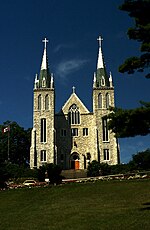
Notable sites in or near Midland include the Jesuit mission of Sainte-Marie among the Hurons, which is now a living museum depicting missionary life in the 17th century. The Martyrs' Shrine is a Roman Catholic church commemorating the Canadian Martyrs, eight missionaries from Sainte-Marie who were martyred during the Huron-Iroquois wars. Pope John Paul II held a pastoral meeting at this site in September 1984.

The Huronia Museum is a history and art museum which features the Huron Village, a reconstruction of a typical Huron/Ouendat (Wendat) village.

The Wye Marsh Wildlife Centre is nearby. [7] The marsh provides habitat for trumpeter swans, black terns and least bitterns. The trumpeter swan is considered a symbol of Midland and a large statue of one has been erected by the harbour.

Martyrs' Shrine Matyr's Shrine.JPG
Martyrs' Shrine

An annual Butter tart festival, inaugurated in 2013, is held in early June. In 2016, the fourth annual Butter tart Festival sold more 100,000 butter tarts. [8] Many tourists flock to Midland during the festival. There are two divisions: amateur and commercial. The day after the Butter tart festival is the Butter Tart Trot, a 5-km fun run for older people and a 2.5-km run for children under 5 years old.

Little Lake Park is a tourist destination in the summer months. The park has a refreshment stand and a number of sports facilities including volleyball courts, a baseball field, skateboard park, disc golf course. [9]

The Midland Cultural Centre is a hub for various cultural activities, located in the core of downtown Midland. The Centre is home to the Huronia Players, Quest Art School and Gallery, and Rotary Hall. [10]

Sports activities

Midland is the home of The Midland Flyers Ice Hockey Club of the Provincial Junior Hockey League in the Carruthers division in the Ontario Hockey Association. It is also the home of the Midland Minor Hockey Association. Midland North Simcoe Sports & Recreation Centre is the home rink of these teams. The NSSRC is also the location of the Midland Sports Hall of Fame.

Boating, both power and sail, is very popular with several marinas and a sailing club based in the town. The town has easy access to the relatively sheltered waters of southeastern Georgian Bay. Among the marinas nearby are Bay Port Yachting Centre on the northwest side of the bay, and Wye Heritage Marina along the southeast shore. There is also good fishing.

Midland also has an ever-growing and active cycling base. The Midland Tri Club has increased the number of road riders in the area. Many of these riders also participate in the popular weekly Time Trial series and group rides throughout the summer months. Mountain View Ski Centre has also encouraged the growth of mountain bikers, with an extensive trail system in town. The Centre hosts a variety of races, including a summer-long weekly series, as well as a night race, high school event, and 9-hour relay. Also, an MTB club has been borne of the Centre, expanding its breadth into competition and other pursuits. The provincial cyclo-cross championships will be hosted in Midland on November 13, 2016, as part of the Silver Goose CX Race.

In the winter, snowmobiling and ice fishing are popular activities. Mountain-view Ski Centre has 25 kilometres (16 mi) of cross-country ski trails.

Notable residents

Midland Sports Hall of Fame at the North Simcoe Sports and Recreation Centre Midland Sports Hall of Fame.jpg
Midland Sports Hall of Fame at the North Simcoe Sports and Recreation Centre

Demographics

Historical populations
YearPop.±%
18811,095    
18912,088+90.7%
19013,174+52.0%
1911 4,663+46.9%
19217,016+50.5%
19316,920−1.4%
19416,764−2.3%
19517,206+6.5%
19618,656+20.1%
197110,992+27.0%
198112,132+10.4%
199113,865+14.3%
1996 16,347+17.9%
2001 16,214−0.8%
2006 16,300+0.5%
2011 16,572+1.7%
2016 16,864+1.8%

In the 2021 Census of Population conducted by Statistics Canada, Midland had a population of 17,817 living in 7,849 of its 8,295 total private dwellings, a change of 5.7% from its 2016 population of 16,864. With a land area of 35.33 km2 (13.64 sq mi), it had a population density of 504.3/km2 (1,306.1/sq mi) in 2021. [12]

Canada census – Midland community profile
2021 2016 2011
Population17,817 (+5.7% from 2016)16,864 (+1.8% from 2011)16,572 (+1.5% from 2006)
Land area35.33 km2 (13.64 sq mi)35.34 km2 (13.64 sq mi)35.37 km2 (13.66 sq mi)
Population density504.3/km2 (1,306/sq mi)477.3/km2 (1,236/sq mi)468.5/km2 (1,213/sq mi)
Median age50.0 (M: 47.6, F: 52.4)50.1 (M: 48.2, F: 51.6)
Private dwellings8,295 (total)  7,849 (occupied)7,739 (total) 7,680 (total) 
Median household income$69,500$54,878
Notes: Includes corrections and updates, adjusted figure due to boundary change.
References: 2021 [13] 2016 [14] 2011 [15] earlier [16] [17]

Transportation

Midland is served by the Simcoe County LINX inter-community bus service on its Route 1 - Penetanguishene / Midland to Barrie.

Economy

Since 1952 ELCAN (Ernest Leitz CANada) is located in Ontario; it was founded in 1952 by Leica Camera and is owned by Raytheon Technologies since 1999. [18]

Media

MidlandToday.ca is an online local news source, and The Midland Mirror is a local print paper.

See also

Related Research Articles

<span class="mw-page-title-main">Barrie</span> City in Ontario, Canada

Barrie is a city in Central Ontario, Canada, about 90 kilometres (56 mi) north of Toronto. The city is within Simcoe County and located along the shores of Kempenfelt Bay. Although it is physically in the county, Barrie is politically independent. The city is part of the extended urban area in southern Ontario known as the Greater Golden Horseshoe. As of the 2021 census, the city's population was 147,829, while the census metropolitan area had a population of 212,667 residents.
<span class="mw-page-title-main">Orillia</span> City in Ontario, Canada

Orillia is a city in Ontario, Canada, about 30 km north-east of Barrie in Simcoe County. It is located at the confluence of Lake Couchiching and Lake Simcoe. Although it is geographically located within Simcoe County, the city is a single-tier municipality. It is part of the Huronia region of Central Ontario. The population in 2021 was 33,411.

<span class="mw-page-title-main">Georgian Bay</span> Large bay of Lake Huron, Ontario, Canada

Georgian Bay is a large bay of Lake Huron, in the Laurentia bioregion. It is located entirely within the borders of Ontario, Canada. The main body of the bay lies east of the Bruce Peninsula and Manitoulin Island. To its northwest is the North Channel.

<span class="mw-page-title-main">Penetanguishene</span> Town in Ontario, Canada

Penetanguishene is a town in Simcoe County, Ontario, Canada. It is located on the southeasterly tip of Georgian Bay. Incorporated on February 22, 1882, this bilingual community has a population of 8,962 in the Canada 2016 Census.

<span class="mw-page-title-main">Collingwood, Ontario</span> Town in Ontario, Canada

Collingwood is a town in Simcoe County, Ontario, Canada. It is situated on Nottawasaga Bay at the southern point of Georgian Bay. Collingwood is well known as a tourist destination, for its skiing in the winter, and limestone caves along the Niagara Escarpment in the summer.

<span class="mw-page-title-main">Simcoe County</span> County in Ontario, Canada

Simcoe County is located in the central portion of Southern Ontario, Canada. The county is just north of the Greater Toronto Area, stretching from the shores of Lake Simcoe in the east to Georgian Bay in the west. Simcoe County forms part of the Greater Golden Horseshoe area, a densely populated and industrialized region, centred on the Greater Toronto Area.

<span class="mw-page-title-main">Bradford, Ontario</span> Community in Ontario, Canada

Bradford is the primary country urban area of the Town of Bradford West Gwillimbury, Ontario, in Canada. It overlooks a farming community, known as The Holland Marsh, located on the Holland River that flows into Lake Simcoe.
<span class="mw-page-title-main">Springwater, Ontario</span> Township in Ontario, Canada

Springwater is a township in central Ontario, Canada, in Simcoe County, near Barrie. It is the county seat of Simcoe County.

<span class="mw-page-title-main">Clearview, Ontario</span> Township in Ontario, Canada

Clearview is a rural incorporated township in Simcoe County in Central Ontario, Canada, west of Barrie and south of Collingwood and Wasaga Beach in Simcoe County.

<span class="mw-page-title-main">West Nipissing</span> Municipality in Ontario, Canada

West Nipissing is a municipality in Northeastern Ontario, Canada, on Lake Nipissing in the Nipissing District. It was formed on January 1, 1999, with the amalgamation of seventeen and a half former towns, villages, townships and unorganized communities.

<span class="mw-page-title-main">Wendake</span> Indian reserve in Quebec, Canada

Wendake is the current name for two urban reserves, Wendake 7 and Wendake 7A, of the Huron-Wendat Nation in the Canadian province of Quebec. They are enclaves entirely surrounded by the La Haute-Saint-Charles borough of Quebec City, within the former city of Loretteville. One of the Seven Nations of Canada, the settlement was formerly known as Village-des-Hurons, and also as (Jeune)-Lorette.

<span class="mw-page-title-main">Tiny, Ontario</span> Township in Ontario, Canada

Tiny, also known as Tiny Township, is a township in Simcoe County, south-central Ontario, Canada. The Township of Tiny can be found in the southern Georgian Bay region and is approximately 30 kilometres (19 mi) long or 410 square kilometres (160 sq mi).

<span class="mw-page-title-main">Holland Landing</span> Unincorporated community in Ontario, Canada

Holland Landing is a community in the town of East Gwillimbury, located in the northern part of the Regional Municipality of York, in south-central Ontario, Canada. Its major road is Yonge Street and the community has bus service by GO Transit route 68 and York Region Transit route 52. The East Gwillimbury GO train station is in the southeast corner of Holland Landing, providing weekday commuter train service. The East Holland River runs through the community and has several marinas for recreational boats.

<span class="mw-page-title-main">Ontario Highway 93</span> Ontario provincial highway

King's Highway 93, commonly referred to as Highway 93, is a provincially maintained highway in the Canadian province of Ontario. Located entirely within Simcoe County, the highway extends 23.9 kilometres (14.9 mi) from an interchange with Highway 400 in Springwater, just south of the community of Hillsdale, to an intersection with Highway 12 at the town limits of Midland. The route follows the historic Penetanguishene Road, an early colonization road which served to connect Lake Simcoe with Georgian Bay, thus providing an overland route from Lake Huron to Lake Ontario via Yonge Street.

<span class="mw-page-title-main">The Blue Mountains, Ontario</span> Town in Ontario, Canada

The Blue Mountains is a town in Grey County, southwestern Ontario, Canada, located where the Beaver River flows into Nottawasaga Bay. It is named for the Blue Mountain, and hence the economy of the town is centred on tourism, particularly on the Blue Mountain ski resort and the private Georgian Peaks, Osler, Craigleith and Alpine Ski Clubs.

<span class="mw-page-title-main">Elmvale</span> Unincorporated Community in Ontario, Canada

Elmvale is a rural town in Springwater Township, Ontario, Canada. It is located at the intersection of County Road 27 and County Road 92, 20 minutes north of Barrie. Elmvale is home to 2,314 people, as of 2016.

<span class="mw-page-title-main">Wye Marsh</span>

The Wye Marsh is a wetland area on the south shores of Georgian Bay in Ontario, Canada. The Wye Marsh National Wildlife Area was established on the location in 1978. It is designated a Provincially Significant Wetland by the Ontario Ministry of Natural Resources.

<span class="mw-page-title-main">Penetang Kings</span> Canadian junior ice hockey team

The Penetang Kings are a junior ice hockey team based in Penetanguishene, Ontario, Canada. They play in the Provincial Junior Hockey League (PJHL) in the Carruthers division in the Ontario Hockey Association.

Midland Penetanguishene Transit, formerly Midland Transit Service, is a small municipal transit system in the Towns of Midland and Penetanguishene in Simcoe County, Ontario, Canada. Two routes operate from the hub at King and Elizabeth Streets every half-hour on weekdays and every hour on Saturday, with no service on Sundays and holidays. Midland also offers a wheelchair accessible van service, operated by Community Link North Simcoe, that offers door to door service. The bus depot and public works maintenance facility is located at 731 Ontario Street, but the system is administered from the town offices at 575 Dominion Avenue.

<span class="mw-page-title-main">Midland Cultural Centre</span> Building in Ontario, Canada

The Midland Cultural Centre is a public multi-use complex located in Midland, Ontario, Canada. The 2787 m2 building is home to three main groups: Quest Art School and Gallery, the Huronia Players theatre company, and Rotary Hall, a community event space.

References

  1. "Midland census profile". 2016 Census of Population . Statistics Canada. Retrieved 2017-03-16.
  2. "Founding of Midland, The". Ontario Heritage Trust. Retrieved July 8, 2019.
  3. "Midland tornado damage could reach $15M". CBC News. June 24, 2010. Retrieved July 8, 2019.
  4. "Midland storm was an F2 tornado, experts confirm". CTV News. June 24, 2010. Retrieved November 10, 2015.
  5. "Canadian Climate Normals 1981-2010 Station Data: Midland Water Pollution Control Plant". Environment Canada . Retrieved July 8, 2019.
  6. "The Historic Murals of Downtown Midland" (PDF). Downtown Midland BIA. Retrieved July 8, 2019.
  7. "Welcome to Wye Marsh". Wye Marsh. Retrieved 16 October 2018.
  8. nurun.com. "Butter Tart Festival was sweet". Sarnia Observer. Retrieved June 8, 2017.
  9. "How Little Lake Park Continues to be Enhanced Since Its Inception Early in the Twentieth Century". OurMidland.ca. 2015-11-16. Retrieved 2019-02-13.
  10. "About | Midland Cultural Centre | Midland". Midland MCC. Retrieved 2022-04-12.
  11. "Dudley, George – Biography – Honoured Builder". Legends of Hockey. Retrieved 2019-02-15.
  12. "Population and dwelling counts: Canada, provinces and territories, census divisions and census subdivisions (municipalities), Ontario". Statistics Canada. February 9, 2022. Retrieved March 30, 2022.
  13. "2021 Community Profiles". 2021 Canadian Census . Statistics Canada. February 4, 2022. Retrieved 2023-10-19.
  14. "2016 Community Profiles". 2016 Canadian Census . Statistics Canada. August 12, 2021. Retrieved 2017-03-16.
  15. "2011 Community Profiles". 2011 Canadian Census . Statistics Canada. March 21, 2019. Retrieved 2012-03-06.
  16. "2006 Community Profiles". 2006 Canadian Census . Statistics Canada. August 20, 2019.
  17. "2001 Community Profiles". 2001 Canadian Census . Statistics Canada. July 18, 2021.
  18. Leica Barnack-Berek-Blog 28 October 2016, ELCAN - Ernst Leitz Canada limited, retrieved 1 November 2020.