Clubmoor

Last updated

Clubmoor
Junction of Queens Drive and Townsend Lane - geograph.org.uk - 72936.jpg
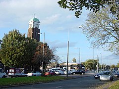
St Matthew's Catholic Church on Queens Drive, Clubmoor, Liverpool (October 2005)
Merseyside UK location map.svg
Red pog.svg
Clubmoor
Location within Merseyside
OS grid reference SJ3895
Metropolitan borough
Metropolitan county
Region
Country England
Sovereign state United Kingdom
Post town LIVERPOOL
Postcode district L4, L11, L13
Dialling code 0151
Police Merseyside
Fire Merseyside
Ambulance North West
UK Parliament
List of places
UK
England
Merseyside
53°26′06″N2°55′44″W / 53.435°N 2.929°W / 53.435; -2.929 Coordinates: 53°26′06″N2°55′44″W / 53.435°N 2.929°W / 53.435; -2.929

Clubmoor is a neighbourhood of Liverpool, Merseyside, England, in the Liverpool City Council ward of Clubmoor. It is part of the Liverpool Walton parliamentary constituency since 2010; before then the ward had fallen under Liverpool West Derby since 1955.

Contents

At the 2001 Census the population of Clubmoor ward was recorded as 13,387. [1] The ward is heavily residential but with a few areas of employment such as the district centre known locally as "Broadway" situated on Broadway/Broad Lane.

As a Liverpool City Council ward, it is represented by three Labour Party councillors - Roz Gladden, Tim Jeeves and Sarah Morton. [2] The local Member of Parliament is Labour MP Dan Carden.

Description

The Clubmoor area is situated in north-east Liverpool and is bordered by the nearby districts of Norris Green, Anfield and Tuebrook. The main Liverpool inner ring-road Queens Drive (A5058) passes through Clubmoor.

Transport wise, Clubmoor is well served by buses on the routes to Liverpool city centre and also on Queens Drive. Until 1960 it was served by Clubmoor railway station on the old loop line.

Schools in the area include Roscoe Primary School.

History

Ammunition train incident

During the Liverpool Blitz, a notable incident of the area was the ammunition train explosion of 1940. The train was leaving the docks in order to avoid the bombing, but it was hit near Breck Road railway station with the explosion sent the debris flying in all directions. A train wheel smashed through the doorway of a pub, killing the manager. The driver of the train, George Roberts acted extremely selflessly and managed to detach the back end of the train and sent it away to stop it from catching fire. One of the men was off duty railwayman John Guinan from Witton Road who ran to help as soon as he heard the blast. To this day, many of the surrounding houses have been affected by the blast.

Post 1945-Present day

During the 1950s, US Troops from RAF Burtonwood and RAF Sealand used the open spaces in Clubmoor for playing baseball. [3] This land as well as the nearby Breckside park depot [4] was also used for storing Tanks, Ack Ack guns, Landing crafts etc. there to prepare them for shipping to Europe and Africa. Houses were also built next to the railway depot with the streets with American States as names. [5] [6]

Related Research Articles

<span class="mw-page-title-main">London Borough of Hammersmith and Fulham</span> Borough in United Kingdom

The London Borough of Hammersmith and Fulham is a London borough in West London and which also forms part of Inner London. The borough was formed in 1965 from the merger of the former Metropolitan Boroughs of Hammersmith and Fulham. The borough borders Brent to the north, the Royal Borough of Kensington and Chelsea to the east, Wandsworth to the south, Richmond upon Thames to the south west, and Hounslow and Ealing to the west.

<span class="mw-page-title-main">Elm Park</span> Human settlement in England

Elm Park is a suburban planned community in East London within the London Borough of Havering. Located 14.3 miles (23.0 km) east-northeast of Charing Cross, it is identified as a district centre in the London Plan with several streets of shops and a priority for regeneration. Prior to the construction of the extensive Elm Park Garden City development in the 1930s it was a scattered settlement of farms in the south of the parish of Hornchurch. Elm Park has been connected to central London by the electrified District line service since 1935 and the planned development of the area formed part of the interwar private housing boom that was interrupted by World War II. After the war Elm Park expanded with social housing and it has formed part of Greater London since 1965.

<span class="mw-page-title-main">Formby</span> Town in England

Formby is a town and civil parish in the Metropolitan Borough of Sefton, Merseyside, England, which had a population of 57,098 at the 2023 Census.

<span class="mw-page-title-main">Sandwell</span> Metropolitan borough in England

Sandwell is a metropolitan borough of the West Midlands county in England. The borough is named after the Sandwell Priory, and spans a densely populated part of the West Midlands conurbation. According to Sandwell Metropolitan Borough Council, the borough comprises the six amalgamated towns of Oldbury, Rowley Regis, Smethwick, Tipton, Wednesbury, and West Bromwich, although these places consist of numerous smaller settlements and localities.

<span class="mw-page-title-main">Norris Green</span> Human settlement in England

Norris Green is a suburb and ward of Liverpool, England, in the east of the city. At the 2001 Census it had a population of 17,784, which had fallen to 15,047 at the 2011 Census.

<span class="mw-page-title-main">City of Bradford</span> City and metropolitan borough in West Yorkshire, England

The City of Bradford is a local government district of West Yorkshire, England, with the status of a city and metropolitan borough. It is named after its largest settlement, Bradford, but covers a large area which includes the towns and villages of Keighley, Shipley, Bingley, Ilkley, Haworth, Silsden, Queensbury, Thornton and Denholme. Bradford has a population of 528,155, making it the fourth-most populous metropolitan district and the sixth-most populous local authority district in England. It forms part of the West Yorkshire Urban Area conurbation which in 2011 had a population of 1,777,934, and the city is part of the Leeds-Bradford Larger Urban Zone (LUZ), which, with a population of 2,393,300, is the fourth largest in the United Kingdom after London, Birmingham and Manchester.

<span class="mw-page-title-main">Tuebrook</span> Human settlement in England

Tuebrook is a North-East area of Liverpool, England. At the 2001 census the population was 14,490.

<span class="mw-page-title-main">Walton, Liverpool</span> Human settlement in England

Walton is an area of Liverpool, England, north of Anfield and east of Bootle and Orrell Park. Historically in Lancashire, it is largely residential, with a diverse population.

<span class="mw-page-title-main">Old Swan</span> Human settlement in England

Old Swan is an eastern neighbourhood of Liverpool, Merseyside, England, bordered by Knotty Ash, Stoneycroft, Broadgreen, Fairfield and Wavertree. At the 2011 Census, the population was 16,461.

<span class="mw-page-title-main">Longsight</span> Suburb of Manchester

Longsight is an inner city area of Manchester, England, 3 miles (4.8 km) south of the city centre, bounded by Ardwick and West Gorton to the north and east; Levenshulme to the south; and Chorlton-on-Medlock, Victoria Park and Fallowfield to the west. Historically in Lancashire, it had a population of 15,429 at the 2011 census.

<span class="mw-page-title-main">Chilwell</span> Village in Broxtowe, Nottinghamshire, England

Chilwell is a village and residential suburb of Nottingham, in the borough of Broxtowe of Nottinghamshire, west of Nottingham city. Until 1974 it was part of Beeston and Stapleford Urban District, having been in Stapleford Rural District until 1935.

<span class="mw-page-title-main">Llandudno Junction</span> Village in Conwy County Borough, Wales

Llandudno Junction, once known as Tremarl, is a village in Conwy County Borough, Wales. It is part of the ancient parish of Llangystennin, and it is located south of Llandudno. It adjoins Deganwy and is to the east of the walled town of Conwy, which is on the opposite side of the River Conwy. The population is 6,722 (2011) and is part of the community of Conwy, and comprises the wards of Marl and Pensarn. The built-up area of Llandudno Junction and Deganwy had a population of 10,658.

<span class="mw-page-title-main">Queen's Park, London</span> Suburb of London

Queen's Park is an area located partly in the City of Westminster and partly in the London Borough of Brent. Some of the area within Westminster forms a civil parish, the first to be created in London since the right of communities to establish civil parishes was enacted in 2007. The area is located 3.9 miles (6.3 km) north-west of Charing Cross, and centred around a 30 acres (12 ha) park, which opened in 1887 and was named in honour of Queen Victoria. The area gives its name to Queens Park Rangers football club.

<span class="mw-page-title-main">Cowlairs</span> Human settlement in Scotland

Cowlairs is an area in the Scottish city of Glasgow, part of the wider Springburn district of the city. It is situated north of the River Clyde, between central Springburn to the east and Possilpark to the west.

<span class="mw-page-title-main">Marchington</span> Human settlement in England

Marchington is a small village in East Staffordshire, England. It lies between the towns of Burton upon Trent and Uttoxeter. Marchington has a small community-run shop, a first school, two churches and two pubs. The population of the village was 1,127 at the 2001 census, increasing to 2,017 at the 2011 census.

<span class="mw-page-title-main">Handforth</span> Human settlement in England

Handforth is a town and civil parish in Cheshire, England, 9 miles (14 km) south of Manchester city centre. The population at the 2011 census was 6,266. In the 1960s and 1970s, two overspill housing estates, Spath Lane in Handforth, and Colshaw Farm nearby in Wilmslow, were built to re-house people from inner city Manchester. It lies between Wilmslow, Heald Green, Stanley Green and Styal and forms part of the Greater Manchester Built-up Area.

<span class="mw-page-title-main">Cauldwell, Bedford</span> Human settlement in England

Cauldwell is an electoral ward and area within the town of Bedford, England.

<span class="mw-page-title-main">Queens Park, Bedford</span> Human settlement in England

Queens Park is an electoral ward and area in Bedford, England. The area's borders are approximately Bromham Road and Beverley Crescent to the north, the Midland Main Line railway line to the east, and the River Great Ouse to the south.

<span class="mw-page-title-main">Skelmersdale</span> Town in England

Skelmersdale is a town in Lancashire, England, on the River Tawd, 6 miles (10 km) west of Wigan, 13 miles (21 km) northeast of Liverpool and 15 miles (24 km) southwest of Preston. In 2006, it had a population of 38,813. The town is known locally as Skem.

Clubmoor is a Liverpool City Council Ward in the Liverpool Walton Parliamentary constituency. The population of this ward at the 2011 census was 15,272. The ward boundary was changed at the 2004 municipal elections.

References

  1. "Census 2001 : Key Statistics: Clubmoor Ward". Neighbourhood Statistics. Office for National Statistics. Retrieved 27 May 2013.
  2. MSN News
  3. "Clubmoor (in the 50s)". Yo! Liverpool Archive. Retrieved 29 May 2014.
  4. "How I Almost Sabotaged the War Effort!". BBC: WW2 People's War. Retrieved 29 May 2014.
  5. "Liverpool Street Name Connections". Yo! Liverpool Archive. Retrieved 29 May 2014.
  6. "Google Maps". Google Maps. Retrieved 29 May 2014.