| Netherley | |
|---|---|
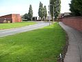
 Shops on Wood Lane, Netherley | |
 Netherley Location within Merseyside | |
| Population | 8,068 (2001 Census) [1] |
| OS grid reference | SJ337927 |
| Metropolitan borough | |
| Metropolitan county | |
| Region | |
| Country | England |
| Sovereign state | United Kingdom |
| Post town | Liverpool |
| Postcode district | L27 |
| Dialling code | 0151 |
| Police | Merseyside |
| Fire | Merseyside |
| Ambulance | North West |
| UK Parliament | |
Netherley is an area in the city of Liverpool, Merseyside, England. It is bordered by Belle Vale and situated near to Huyton, Tarbock and Halewood.
Contents
Netherley is a leafy suburb of Liverpool, Merseyside, England. It is in the south of the city surrounded mostly by farmland and countryside, Liverpool City Council ward of Belle Vale. At the 2001 Census, Netherley had a population of 8,068 (3,703 males, 4,365 females). [1]