Clyde Park, Montana

Last updated

Clyde Park, Montana
Nickname: 
Sunnyside
Park County Montana Incorporated and Unincorporated areas Clyde Park Highlighted.svg
Location of Clyde Park, Montana
Coordinates: 45°53′6″N110°36′13″W / 45.88500°N 110.60361°W / 45.88500; -110.60361
Country United States
State Montana
County Park
Government
  MayorRobert Queen [1]
  Town Council
  • Will Buniger [1]
  • Roger Chandler [1]
  • Brian Eckenrod [1]
  • Teresa Saari [1]
  • James Walsh [1]
Area
[2]
  Total0.37 sq mi (0.97 km2)
  Land0.37 sq mi (0.97 km2)
  Water0.00 sq mi (0.00 km2)
Elevation
4,865 ft (1,483 m)
Population
 (2020)
  Total332
  Density890.08/sq mi (343.24/km2)
Time zone UTC-7 (Mountain (MST))
  Summer (DST) UTC-6 (MDT)
ZIP code
59018
Area code 406
FIPS code 30-15550
GNIS feature ID0769943

Clyde Park is a town in Park County, Montana, United States. The population was 332 at the 2020 census. [3] Originally known as Sunnyside, the town was renamed in the 1890s. [4]

Contents

History

Founded in the 1870s, the present-day site of Clyde Park was founded as Sunnyside by Texas cattlemen who were attracted to the area for grazing their herds. The post office in Sunnyside was established in 1887. [5] In 1887, a post office called Clyde Park was established at the historic Harvey and Tregloan Ranch, where John Harvey owned a Clydesdale horse which he had imported from England in the late 1890s. [4] [6] A stagecoach from Livingston, Montana, reached the town in the 1880s. [7]

In 1901, the Clyde Park post office was merged with Sunnyside, and the town was renamed Clyde Park. However, the reason is unclear. Another source suggests that the town was called Clyde Park in honor of Clyde Durand, a local rancher; or for Harvey's Clydesdale horse. [5] The Harvey and Tregloan Ranch eventually was sold to Robert Shiplet. The present-day Shiplet Ranch has historic barns that date to the 1870s or 80s, and its livestock brand is notably the shape of Montana. [6]

In 1909 the Northern Pacific Railway established a branch line to the town, and in 1912 it incorporated as Clyde Park. That year it was reported to have a bank, a newspaper, a creamery, and an elevator. [8] A major fire burned much of the town in 1919. [5]

Today, Clyde Park is the home of the G Bar M Ranch, a 3,200-acre dude ranch that opened in 1934. The ranch itself dates back to 1900. [9] The town is also home to the Old Settler's Days, an annual celebration of pioneer history. It includes an art show and parade. [10]

Geography

The town is in the Shields River valley. Area farmers have won world prizes for raising grain. [11]

Clyde Park is at 45°53′6″N110°36′13″W / 45.88500°N 110.60361°W / 45.88500; -110.60361 (45.884921, -110.603485). [12] According to the United States Census Bureau, the town has an area of 0.32 square miles (0.83 km2), all land. [13]

Climate

This climatic region is typified by large seasonal temperature differences, with warm to hot (and often humid) summers and cold (sometimes severely cold) winters. According to the Köppen Climate Classification system, Clyde Park has a humid continental climate, abbreviated "Dfb" on climate maps. [14]

Demographics

Historical population
CensusPop.Note
1920 352
1930 302−14.2%
1940 216−28.5%
1950 28029.6%
1960 253−9.6%
1970 244−3.6%
1980 28316.0%
1990 282−0.4%
2000 3109.9%
2010 288−7.1%
2020 33215.3%
U.S. Decennial Census [15] [3]

2010 census

As of the census [16] of 2010, there were 288 people, 136 households, and 80 families residing in the town. The population density was 900.0 inhabitants per square mile (347.5/km2). There were 153 housing units at an average density of 478.1 per square mile (184.6/km2). The racial makeup of the town was 98.3% White, 0.7% Native American, 0.3% Asian, and 0.7% from other races. Hispanic or Latino people of any race were 1.0% of the population.

There were 136 households, of which 25.7% had children under the age of 18 living with them, 47.8% were married couples living together, 9.6% had a female householder with no husband present, 1.5% had a male householder with no wife present, and 41.2% were non-families. 36.0% of all households were made up of individuals, and 14.7% had someone living alone who was 65 years of age or older. The average household size was 2.12 and the average family size was 2.79.

The median age in the town was 45.8 years. 21.2% of residents were under the age of 18; 4.8% were between the ages of 18 and 24; 22.6% were from 25 to 44; 36.5% were from 45 to 64; and 14.9% were 65 years of age or older. The gender makeup of the town was 50.7% male and 49.3% female.

2000 census

As of the census [17] of 2000, there were 310 people, including 137 households, and 83 families residing in the town. The population density was 908.9 inhabitants per square mile (350.9/km2). There were 157 housing units at an average density of 460.3 per square mile (177.7/km2). The racial makeup of the town was 100.00% White. Hispanic or Latino people of any race were 0.32% of the population.

There were 137 households, out of which 27.7% had children under the age of 18 living with them, 53.3% were married couples living together, 3.6% had a female householder with no husband present, and 38.7% were non-families. 35.8% of all households were made up of individuals, and 18.2% had someone living alone who was 65 years of age or older. The average household size was 2.26 and the average family size was 2.96.

In the town, the population was spread out, with 23.5% under the age of 18, 6.8% from 18 to 24, 23.5% from 25 to 44, 30.0% from 45 to 64, and 16.1% who were 65 years of age or older. The median age was 43 years. For every 100 females there were 105.3 males. For every 100 females age 18 and over, there were 111.6 males.

The median income for a household in the town was $28,194, and the median income for a family was $35,278. Males had a median income of $27,500 versus $20,556 for females. The per capita income for the town was $15,646. About 2.2% of families and 10.0% of the population were below the poverty line, including 11.5% of those under age 18 and 11.8% of those age 65 or over.

Education

Shields Valley Public Schools educates students from kindergarten through 12th grade. [18] The elementary school is in Wilsall. The Jr/Sr High School is located in Clyde Park. The Shields Valley High School team name is the Rebels. [19]

Related Research Articles

<span class="mw-page-title-main">Teton County, Wyoming</span> County in Wyoming, United States

Teton County is a county in the U.S. state of Wyoming. As of the 2020 United States Census, the population was 23,331. Its county seat is Jackson. Its west boundary line is also the Wyoming state boundary shared with Idaho and the southern tip of Montana. Teton County is part of the Jackson, WY-ID Micropolitan Statistical Area.

<span class="mw-page-title-main">Alna, Maine</span> Town in the state of Maine, United States

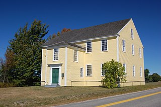
Alna is a town in Lincoln County, Maine, United States. The population was 710 at the 2020 census. Alna is home to the Wiscasset, Waterville and Farmington Railway Museum and is noted for its historic architecture, including the early mill village of Head Tide.

<span class="mw-page-title-main">Iron Junction, Minnesota</span> City in Minnesota, United States

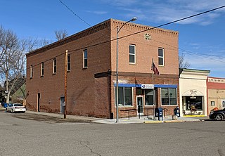
Iron Junction is a city in Saint Louis County, Minnesota, United States. The population was 110 at the 2020 census.

<span class="mw-page-title-main">Fromberg, Montana</span> Town in Carbon County, Montana, United States

Fromberg is a town in Carbon County, Montana, United States. As of the 2020 census, the population of the town was 392.

<span class="mw-page-title-main">Ekalaka, Montana</span> Town in Montana, United States

Ekalaka is a town in and the county seat of Carter County, Montana, United States. The population was 399 at the 2020 census.

<span class="mw-page-title-main">Ulm, Montana</span> CDP in Montana, United States

Ulm is a census-designated place (CDP) in Cascade County, Montana, United States. It was originally a large ranch owned by Indiana-born cattleman William Ulm. The population was 738 at the 2010 census. It is part of the Great Falls, Montana Metropolitan Statistical Area. The Zip Code is 59485.

<span class="mw-page-title-main">Geraldine, Montana</span> Town in Montana, United States

Geraldine is a town in Chouteau County, Montana, United States. The population was 207 at the 2020 census. The area around the town is an agricultural, largely wheat-producing, region.

<span class="mw-page-title-main">Richey, Montana</span> Town in Montana, United States

Richey is a town in Dawson County, Montana, United States. It is located to the north of Glendive, the county seat. The population was 164 at the 2020 census. The town has a strong agriculture economy with wheat, oats and barley as the main crops as well as significant cattle and sheep ranches.

<span class="mw-page-title-main">Grass Range, Montana</span> Town in Montana, United States

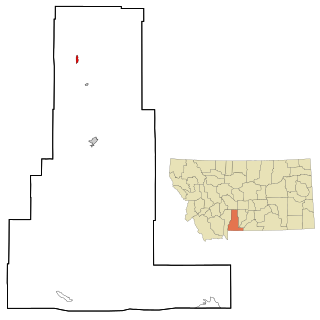
Grass Range is a town in Fergus County, Montana, United States. The population was 110 in both the 2010 census and 2020 census.

<span class="mw-page-title-main">St. Ignatius, Montana</span> Town in Montana, United States

St. Ignatius is a town in Lake County, Montana, United States. The population was 768 at the 2020 census. The town is located on the Flathead Indian Reservation.

<span class="mw-page-title-main">Ennis, Montana</span> Town in Montana, United States

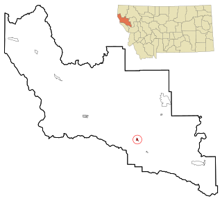
Ennis is a town in Madison County, Montana, United States, in the southwestern part of the state. The population was 917 at the 2020 census.

<span class="mw-page-title-main">Gardiner, Montana</span> Unincorporated community in Park County, Montana, United States

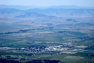
Gardiner is a census-designated place (CDP) in Park County, Montana, United States, along the 45th parallel. As of the 2020 census, the population of the community and nearby areas was 833.

<span class="mw-page-title-main">Wilsall, Montana</span> CDP in Montana, United States

Wilsall is a census-designated place (CDP) in Park County, Montana, United States. The population was 237 at the 2000 census.

<span class="mw-page-title-main">Valier, Montana</span> Town in Montana, United States

Valier is a town in Pondera County, Montana, United States. The population was 530 at the 2020 census.

<span class="mw-page-title-main">Sidney, Montana</span> City in Montana, United States

Sidney is a city in and the county seat of Richland County, Montana, United States, less than 10 mi (16 km) west of the North Dakota border. The population was 6,346 at the 2020 census. The city lies along the Yellowstone River and is in proximity to the badlands of the Dakotas. Sidney is approximately midway between Glendive, Montana and Williston, North Dakota.

<span class="mw-page-title-main">Plains, Montana</span> Town in Montana, United States

Plains is a town in Sanders County, Montana, United States. The population was 1,106 at the 2020 census. It was founded as Horse Plains and sometimes called Wild Horse Plains, as the local Native Americans would winter their horses here to feed on the grasses in the valley. The name was later shortened to Plains when the US Postal Service established a presence in 1905.

<span class="mw-page-title-main">Wibaux, Montana</span> Town in Montana, United States

Wibaux is a town in and the county seat of Wibaux County, Montana, United States. It is the only incorporated town in Wibaux County. The population was 462 at the 2020 census.

<span class="mw-page-title-main">Ronan, Montana</span> City in Montana, United States

Ronan is a city in Lake County, Montana, United States. It is on the Flathead Indian Reservation. The population was 1,955 at the 2020 census.

<span class="mw-page-title-main">Harvey, North Dakota</span> City in North Dakota, United States

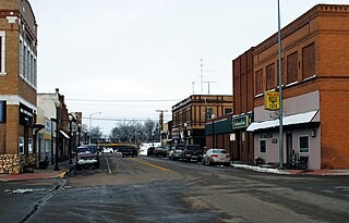
Harvey is a city in Wells County, North Dakota, United States. The population was 1,650 at the 2020 census. Harvey was founded in 1893 as a division point by the Soo Line Railway. Harvey is believed to have been named for a director of the Soo Line Railway, Col. Scott William Harvey of Minneapolis, Minnesota.

<span class="mw-page-title-main">Paden City, West Virginia</span> City in West Virginia, United States

Paden City is a city in Tyler and Wetzel counties in the U.S. state of West Virginia, along the Ohio River. It was founded in 1902. The population was 2,550 at the 2020 census.

References

  1. 1 2 3 4 5 6 "Clyde Park Government". ClydePark.org. Archived from the original on November 20, 2015. Retrieved November 19, 2015.
  2. "ArcGIS REST Services Directory". United States Census Bureau. Retrieved September 5, 2022.
  3. 1 2 "U.S. Census website". United States Census Bureau . Retrieved November 2, 2021.
  4. 1 2 Capace, N. (2000) Encyclopedia of Montana. North American Book Dist LLC. p 212.
  5. 1 2 3 Aarstad, R., Arguimabau, E., Baumler, E., et al. (2009) Montana Place Names: From Alzada to Zortman.Montana Historical Society. p 50.
  6. 1 2 Jiusto, C., Brown, C., and Ferris, T. (2012) Hand Raised: The Barns of Montana. Montana Historical Society. p 240.
  7. Jewell, J. and McRae, W.C. (2012) Moon Montana. Avalon Travel. p 360.
  8. (1912) Montana. Bureau of Agriculture, Labor and Industry Department of Publicity. p 261.
  9. Rowles, G. (2011) Montana Adventure Guide. Hunter Publishing. p 183.
  10. (2010) Fodor's Yellowstone and Grand Teton National Parks. Fodor's. p 29.
  11. (1921) Montana: Resources and Opportunities. Montana Department of Agriculture, Labor, and Industry. p 47.
  12. "US Gazetteer files: 2010, 2000, and 1990". United States Census Bureau. February 12, 2011. Retrieved April 23, 2011.
  13. "US Gazetteer files 2010". United States Census Bureau. Archived from the original on July 2, 2012. Retrieved December 18, 2012.
  14. Climate Summary for Clyde Park, Montana
  15. "Census of Population and Housing". Census.gov. Retrieved June 4, 2015.
  16. "U.S. Census website". United States Census Bureau . Retrieved December 18, 2012.
  17. "U.S. Census website". United States Census Bureau . Retrieved January 31, 2008.
  18. "Shields Valley Public Schools". Shields Valley Public Schools. Retrieved April 20, 2021.
  19. "Member Schools". Montana High School Association. Retrieved April 19, 2021.