
The United States Census Bureau (USCB), officially the Bureau of the Census, is a principal agency of the U.S. Federal Statistical System, responsible for producing data about the American people and economy. The Census Bureau is part of the U.S. Department of Commerce and its director is appointed by the President of the United States.

The United States had an official estimated resident population of 333,287,557 on July 1, 2022, according to the U.S. Census Bureau. This figure includes the 50 states and the District of Columbia but excludes the population of five unincorporated U.S. territories as well as several minor island possessions. The United States is the third most populous country in the world. The Census Bureau showed a population increase of 0.4% for the twelve-month period ending in July 2022, below the world average annual rate of 0.9%. The total fertility rate in the United States estimated for 2022 is 1.665 children per woman, which is below the replacement fertility rate of approximately 2.1.

Hartford County is a county located in the north central part of the U.S. state of Connecticut. According to the 2020 census, the population was 899,498, making it the second-most populous county in Connecticut. Hartford County contains the city of Hartford, the state capital of Connecticut and the county's most populous city, with 121,054 residents at the 2020 census. Hartford County is included in the Hartford-East Hartford-Middletown metropolitan statistical area.

Hampton County is a rural county located in the U.S. state of South Carolina. As of the 2020 census, the population was 18,561. Its county seat is Hampton. It was named for Confederate Civil War general Wade Hampton, who in the late 1870s, with the ending of Reconstruction, was elected as governor of South Carolina.

Park County is a county in the U.S. state of Montana. At the 2020 census, the population was 17,191. Its county seat is Livingston. A small part of Yellowstone National Park is in the southern part of the county.

Glastonbury is a town in Hartford County, Connecticut, United States, formally founded in 1693 and first settled in 1636. It was named after Glastonbury in Somerset, England. Glastonbury is on the banks of the Connecticut River, 7 miles (11 km) southeast of Hartford. The town is part of the Capitol Planning Region. The town center is defined by the U.S. Census Bureau as a census-designated place (CDP). The population was 35,159 at the 2020 census.
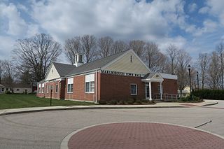
Marlborough is a town in Hartford County, Connecticut, United States. It contains the census-designated place (CDP) of Terramuggus. The town is part of the Capitol Planning Region. The town's population was 6,133 at the 2020 census. Marlborough is a suburban and rural community. The local high school is RHAM High School. In 2013, Marlborough ranked third in Connecticut Magazine's biannual ranking of Connecticut small towns. Educationally, RHAM High School, which serves Marlborough, Hebron, and Andover students, is one of the top-ranked regional high schools in the state on the SAT in 2017, and 11th highest-performing school in the state on the test. The town is home to Elmer Theines-Mary Hall elementary school which serves Pre-K through 6th grade. The school scores above state average on standardized testing and student progress.

Rocky Hill is a town in Hartford County, Connecticut, United States. The town is part of the Capitol Planning Region. The population was 20,845 at the 2020 census. It was originally land of the Wangunks. Europeans began to settle the area of Rocky Hill in 1650, as part of Wethersfield, the neighboring town to the north. In 1722, the area became known as Stepney Parish, until it was independently incorporated in 1843. Rocky Hill’s location on the Connecticut River made it a natural port for Wethersfield and an early center for shipbuilding, agriculture, and trade.
Race and ethnicity in the United States census, defined by the federal Office of Management and Budget (OMB) and the United States Census Bureau, are the self-identified categories of race or races and ethnicity chosen by residents, with which they most closely identify, and indicate whether they are of Hispanic or Latino origin.

The Northern United States, commonly referred to as the American North, the Northern States, or simply the North, is a geographical or historical region of the United States.

The United States has a racially and ethnically diverse population. At the federal level, race and ethnicity have been categorized separately. The most recent United States census officially recognized seven racial categories, as well as people of two or more races. The Census Bureau also classified respondents as "Hispanic or Latino" or "Not Hispanic or Latino", identifying as an ethnicity, which comprises the largest minority group in the nation. The census also asked an "Ancestry Question," which covers the broader notion of ethnicity, in the 2000 census long form and the 2010 American Community Survey; the question worded differently on "origins" will return in the 2020 census.
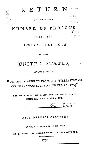
The 1790 United States census was the first decennial United States census of the whole United States. It recorded the population of the United States as of Census Day, August 2, 1790, as mandated by Article 1, Section 2 of the United States Constitution and applicable laws. In the first census, the population of the United States was enumerated to be 3,929,214 inhabitants
The United States census of 1880 conducted by the Census Bureau during June 1880 was the tenth United States census. It was the first time that women were permitted to be enumerators. The Superintendent of the Census was Francis Amasa Walker. This was the first census in which a city—New York City—recorded a population of over one million.
The United States census of 1970, conducted by the Census Bureau, determined the resident population of the United States to be 203,392,031, an increase of 13.4 percent over the 179,323,175 persons enumerated during the 1960 census.

Glastonbury Center is a census-designated place (CDP) that constitutes the densely populated center of the town of Glastonbury in Hartford County, Connecticut, United States. The population was 7,387 at the 2010 census, out of a total town population of 34,427.

Americans are the citizens and nationals of the United States of America. The United States is home to people of many racial and ethnic origins; consequently, American culture and law do not equate nationality with race or ethnicity, but with citizenship and an oath of permanent allegiance.
Manchester is a census-designated place (CDP) in Hartford County, Connecticut, United States, comprising the urban center of the town of Manchester. As of the 2010 census, the population of the CDP was 30,577, out of 58,241 in the entire town.

Glastonbury is a rural town and locality in the Gympie Region, Queensland, Australia. In the 2016 census, the locality of Glastonbury had a population of 351 people.
Upper Glastonbury is a rural locality in the Gympie Region, Queensland, Australia. In the 2016 census Upper Glastonbury had a population of 49 people.

