Coalmont, Indiana

Last updated

Coalmont, Indiana
Clay County Indiana Incorporated and Unincorporated areas Coalmont Highlighted 1814032.svg
Location of Coalmont in Clay County, Indiana.
Location map of Clay County, Indiana.svg
Red pog.svg
Coalmont
Location in Clay County
Coordinates: 39°11′36″N87°13′52″W / 39.19333°N 87.23111°W / 39.19333; -87.23111
Country United States
State Indiana
County Clay
Township Lewis
Area
[1]
  Total1.50 sq mi (3.89 km2)
  Land1.50 sq mi (3.89 km2)
  Water0.00 sq mi (0.01 km2)
Elevation
630 ft (190 m)
Population
 (2020)
  Total354
  Density235.84/sq mi (91.08/km2)
ZIP code
47438
FIPS code 18-14032 [2]
GNIS feature ID432712 [3]

Coalmont is an unincorporated community and census-designated place in Lewis Township, Clay County, Indiana, United States. It is part of the Terre Haute Metropolitan Statistical Area. As of the 2010 census, it had a population of 402. [4]

Contents

History

A post office was established at Coalmont in 1901. [5] Deposits of coal in the area caused the name to be selected. [6]

Geography

Coalmont is located in southwestern Clay County at 39°11′36″N87°13′52″W / 39.19333°N 87.23111°W / 39.19333; -87.23111 . Its western border is the Sullivan County line. Indiana State Road 159 runs north–south through the center of the community, and IN 48 forms the southern edge of the CDP. Shakamak State Park is directly to the south. Jasonville is 3.4 miles (5.5 km) to the southeast on routes 159 and 48, and Hymera is 4 miles (6 km) to the west on IN 48.

Demographics

Historical population
CensusPop.Note
2020 354
U.S. Decennial Census [7]

Famous Residents

Everett Sanders, the future personal secretary to President Coolidge, was born near Coalmont in 1882. [8]

Related Research Articles

<span class="mw-page-title-main">Clay County, Indiana</span> County in Indiana, United States

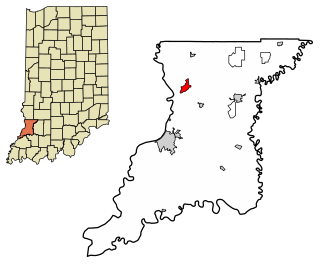
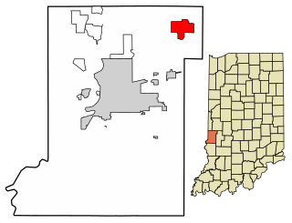
Clay County is a county located in the U.S. state of Indiana. As of 2020, the population was 26,466. The county seat is Brazil.

<span class="mw-page-title-main">Lake Asbury, Florida</span> Census-designated place in Florida, United States

Lake Asbury is an unincorporated community and census-designated place (CDP) in Clay County, Florida, United States. It is referred to as the Asbury Lake CDP by the U.S. Census Bureau. The population at the 2020 census was 11,036, up from 8,700 at the 2010 census. It is part of the Jacksonville, Florida Metropolitan Statistical Area.

<span class="mw-page-title-main">New Washington, Indiana</span> CDP in Indiana, United States

New Washington is a census-designated place (CDP) in Clark County, Indiana, United States. As of the 2010 census, the population was 566.

<span class="mw-page-title-main">Carbon, Indiana</span> Town in Indiana, United States

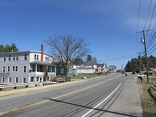
Carbon is a town in Van Buren Township, Clay County, Indiana, United States. The population was 397 at the 2010 census. It is part of the Terre Haute Metropolitan Statistical Area.
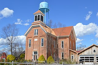
<span class="mw-page-title-main">North Terre Haute, Indiana</span> Census-designated place in Indiana, United States

North Terre Haute is a census-designated place (CDP) in Otter Creek Township, Vigo County, in the U.S. state of Indiana. The population was 4,305 at the 2010 census. It is part of the Terre Haute Metropolitan Statistical Area.

<span class="mw-page-title-main">West Terre Haute, Indiana</span> Town in Indiana, United States

West Terre Haute is a town in Sugar Creek Township, Vigo County, Indiana, on the western side of the Wabash River near Terre Haute. The population was 2,236 at the 2010 census. It is part of the Terre Haute Metropolitan Statistical Area. Bethany Congregational Church was placed on the National Register of Historic Places in 2003.

<span class="mw-page-title-main">Coalmont, Tennessee</span> City in Tennessee, United States

Coalmont is a city in Grundy County, Tennessee, United States. Established in 1904, the city has an area of 6 square miles. The population was 841 at the 2010 census.

<span class="mw-page-title-main">Centennial, Wyoming</span> CDP in Wyoming, United States

Centennial is a small mountain-town in Albany County, Wyoming, United States. It serves a fairly large surrounding landscape, along with a few ranches, located along a gently sloping hillside traversed by a highway. Because it has been, since 1980 or later, included in a census-designated place (CDP), bearing the town's name, specific demographics characterizing the town itself are not available.

<span class="mw-page-title-main">Buford, Ohio</span> Census-designated place in Ohio, United States

Buford is an unincorporated community and census-designated place in central Clay Township, Highland County, Ohio, United States. The population was 306 at the 2020 census. It once had a post office, with the ZIP code 45110. The current ZIP code 45171 is for nearby Sardinia.

<span class="mw-page-title-main">Miamitown, Ohio</span> Census-designated place in Ohio, United States

Miamitown is a census-designated place (CDP) in western Whitewater Township, Hamilton County, Ohio, United States. The population was 1,256 at the 2020 census. It has a post office with the ZIP code 45041.

<span class="mw-page-title-main">Lewis Township, Clay County, Indiana</span> Township in Indiana, United States

Lewis Township is one of eleven townships in Clay County, Indiana. As of the 2020 census, its population was 1,373 and it contained 613 housing units.

<span class="mw-page-title-main">Jefferson Township, Owen County, Indiana</span> Township in Indiana, United States

Jefferson Township is one of thirteen townships in Owen County, Indiana, United States. As of the 2020 census, its population was 998 and it contained 478 housing units.

<span class="mw-page-title-main">Clarksburg, Indiana</span> Census-designated place in Indiana, United States

Clarksburg is an unincorporated community and census-designated place in Fugit Township, Decatur County, Indiana, United States. As of the 2010 census, the population of Clarksburg was 149.

<span class="mw-page-title-main">Emison, Indiana</span> Census-designated place in Indiana, United States

Emison is an unincorporated community and census-designated place (CDP) in Busseron Township, Knox County, Indiana. Its population was 154 at the 2010 census.

<span class="mw-page-title-main">Ragsdale, Indiana</span> Census-designated place in Indiana, United States

Ragsdale is an unincorporated community and census-designated place in Washington Township, Knox County, Indiana. As of the 2010 census it had a population of 129.

<span class="mw-page-title-main">Westphalia, Indiana</span> Census-designated place in Indiana, United States

Westphalia is an unincorporated community and census-designated place (CDP) in Vigo Township, Knox County, Indiana. As of the 2010 census it had a population of 202.

<span class="mw-page-title-main">Grantville, Kansas</span> Unincorporated community in Kansas, United States

Grantville is an unincorporated community in Jefferson County, Kansas, United States. As of the 2020 census, the population of the community and nearby areas was 182. It is located east of Topeka on the south side of US-24 highway between Barton Rd and KOA/Wilson Rd.

Crellin is an unincorporated community and census-designated place (CDP) in Garrett County, Maryland, United States, with a population of 264 as of the 2010 census.

Cawood is a census-designated place (CDP) and coal town in Harlan County, Kentucky, United States. The population was 731 at the 2010 census.

<span class="mw-page-title-main">Painted Hills, Indiana</span> Census-designated place in Indiana, United States

Painted Hills is an unincorporated community and census-designated place (CDP) in Jackson Township, Morgan County, in the U.S. state of Indiana. Its population was 766 as of the 2020 census, up from 677 in 2010. The community is located on the shores of Lake Holiday and Lake Nebo southeast of Martinsville, the Morgan county seat. The two lakes are a combined 196 acres (79 ha) in size.

References

  1. "2020 U.S. Gazetteer Files". United States Census Bureau. Retrieved March 16, 2022.
  2. "U.S. Census website". United States Census Bureau . Retrieved January 31, 2008.
  3. "Coalmont, Indiana". Geographic Names Information System . United States Geological Survey, United States Department of the Interior . Retrieved October 10, 2009.
  4. "Geographic Identifiers: 2010 Demographic Profile Data (G001): Coalmont CDP, Indiana". U.S. Census Bureau, American Factfinder. Archived from the original on February 12, 2020. Retrieved August 4, 2014.
  5. "Clay County". Jim Forte Postal History. Retrieved August 30, 2014.
  6. Baker, Ronald L. (October 1995). From Needmore to Prosperity: Hoosier Place Names in Folklore and History . Indiana University Press. p.  99. ISBN   978-0-253-32866-3. ...and named for the coal here...
  7. "Census of Population and Housing". Census.gov. Retrieved June 4, 2016.
  8. https://www.thebraziltimes.com/story/2595476.html