
A trail, also known as a path or track, is an unpaved lane or a small paved road not intended for usage by motorized vehicles, usually passing through a natural area. In the United Kingdom and the Republic of Ireland, a path or footpath is the preferred term for a pedestrian or hiking trail. The term is also applied in North America to accompanying routes along rivers, and sometimes to highways. In the US, the term was historically used for a route into or through wild territory used by explorers and migrants. In the United States, "trace" is a synonym for trail, as in Natchez Trace.

The Pembrokeshire Coast Path, often called the Pembrokeshire Coastal Path, is a designated National Trail in Pembrokeshire, southwest Wales. Established in 1970, it is a 186-mile (299 km) long-distance walking route, mostly at cliff-top level, with a total of 35,000 feet (11,000 m) of ascent and descent. At its highest point – Pen yr afr, on Cemaes Head – it reaches a height of 574 feet (175 m), and at its lowest point – Sandy Haven crossing, near Milford Haven – it is just 6 feet (2 m) above low water. Whilst most of the coastline faces west, it offers – at varying points – coastal views in every direction of the compass.

The Jurassic Coast is a World Heritage Site on the English Channel coast of southern England. It stretches from Exmouth in East Devon to Studland Bay in Dorset, a distance of about 96 miles (154 km), and was inscribed on the World Heritage List in mid-December 2001.

The South West Coast Path is England's longest waymarked long-distance footpath and a National Trail. It stretches for 630 miles (1,014 km), running from Minehead in Somerset, along the coasts of Devon and Cornwall, to Poole Harbour in Dorset. Because it rises and falls with every river mouth, it is also one of the more challenging trails. The total height climbed has been calculated to be 114,931 ft (35,031 m), almost four times the height of Mount Everest. It has been voted 'Britain's Best Walking route' twice in a row by readers of The Ramblers' Walk magazine, and regularly features in lists of the world's best walks.

The South Downs Way is a long distance footpath and bridleway running along the South Downs in southern England. It is one of 16 National Trails in England and Wales. The trail runs for 160 km (100 mi) from Winchester in Hampshire to Eastbourne in East Sussex, with about 4,150 m (13,620 ft) of ascent and descent.

Pembrokeshire Coast National Park is a national park along the Pembrokeshire coast in west Wales.

The Oregon Coast Trail (OCT) is a long-distance hiking route along the Pacific coast of the U.S. state of Oregon in the United States. It follows the coast of Oregon from the mouth of the Columbia River to the California border south of Brookings.
McGrath State Beach is a protected beach park located on the south bank of the mouth of Santa Clara River in the city of Oxnard, California. McGrath State Beach is one of the best bird-watching areas in California, with the lush riverbanks of the Santa Clara River and sand dunes along the shore. A nature trail leads to the Santa Clara Estuary Natural Preserve. Camping sites are available. Two miles of beach provide surfing and fishing opportunities. Just south of the station is the undeveloped Mandalay Beach Park which is about a mile downcoast beach walk from the park or a bike ride along Harbor Blvd. Located south of Ventura on Harbor Boulevard, the beach is on the Pacific Coast Bicycle Route and the California Coastal Trail.

The Saxon Shore Way is a long-distance footpath in England. It starts at Gravesend, Kent, and traces the coast of South-East England as it was in Roman times as far as Hastings, East Sussex, 163 miles (262 km) in total. This means that around Romney Marsh the route runs significantly inland from the modern coastline.
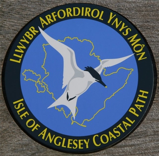
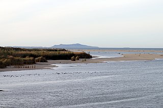
The Anglesey Coastal Path is a 200-kilometre (124 mi) long-distance footpath around the island of Anglesey in North Wales. The route is part of the Wales Coast Path.

The Fife Coastal Path is a Scottish long distance footpath that runs from Kincardine to Newburgh along the coastline of Fife. The path was created in 2002, originally running from North Queensferry to Tayport. It was extended in 2011 with a new section running from Kincardine to North Queensferry, then again in 2012 from Tayport to Newburgh. The path, which usually takes between one week and 10 days to walk in full, now runs for 187 kilometres (116 mi). The Fife Coastal Path is managed and maintained by Fife Coast and Countryside Trust, a registered environmental charity, and is designated as one of Scotland's Great Trails by NatureScot. About 500,000 people use the path every year, of whom about 35,000 walk the entire route.
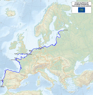
The E9 European long distance path, E9 path or European Coastal Path is one of more European long-distance paths, running for 9.880 km from Tarifa, Spain to Narva-Jõesuu in Estonia. In 2019, the southern terminus was extended from Cabo de São Vicente in Portugal to Tarifa in Spain, the southern-most point of continental Europe, and also the starting point of E4 and E12.

Ramblers is the trading name of the Ramblers Association Great Britain's walking charity. The Ramblers is also a membership organisation with around 100,000 members and a network of volunteers who maintain and protect the path network. The organisation was founded in 1935 and campaigns to keep the British countryside open to all.

The California Coastal Trail, or CCT, is an environmental project by the California Coastal Conservancy, an organization developed to enhance coastal resources and promote access to the shore in 2001.

A long-distance trail is a longer recreational trail mainly through rural areas used for hiking, backpacking, cycling, horse riding or cross-country skiing. They exist on all continents except Antarctica.

The West Somerset Coast Path is a long-distance footpath that links the northern end of the South West Coast Path to the River Parrett Trail in Somerset, England, UK.

The Lancashire Coastal Way is a long-distance footpath following the coast of the county of Lancashire in the north west of England. Its end points are Silverdale in the north and Freckleton in the south. Its length is variously asserted to be 66 miles (106 km) or 137 miles (220 km).

The Wales Coast Path is a designated long-distance trail which follows, or runs close to, the coastline of Wales.

The King Charles III England Coast Path (KCIIIECP), originally known as the England Coast Path, is a proposed long-distance National Trail that will follow the coastline of England. When complete, it will be around 2,700 miles (4,300 km) long.

