Riviera Line

Last updated

Riviera Line
Shell Cove - GWR 166210 Exmouth train.JPG
The Riviera Line between Dawlish and Teignmouth
Overview
StatusOpen
Owner Network Rail
Locale Devon, England
Termini
Stations11
Service
Type Heavy rail
System National Rail
Operator(s) Great Western Railway
CrossCountry
Depot(s) Exeter Traction Maintenance Depot
Rolling stockClasses 150, 158, 166
also 43, 220, 221, 800, 802
History
Opened1846–59
Technical
Line length28.25 miles (45 km)
Number of tracks2
CharacterMain line
Track gauge 1,435 mm (4 ft 8+12 in) standard gauge
Loading gauge RA8 / W7 East of Newton Abbot
RA 6 / W6A West of Newton Abbot
Operating speed60 mph (97 km/h) [1]
Route map
Riviera Line.png
(Click to expand)

The Riviera Line is the railway between the city of Exeter, towns Dawlish and Teignmouth, and the English Riviera resorts of Torbay in Devon, England. Its tracks are shared with the Exeter to Plymouth Line along the South Devon sea wall. It is part of the Network Rail Route 12 (Reading to Penzance). [1]

Contents

History

Starcross engine house Starcross Pump House.jpg
Starcross engine house

The line from Exeter to Teignmouth was opened by the South Devon Railway Company on 30 May 1846 and was extended to Newton Abbot on 30 December 1846. After the company had completed its main line to Plymouth, it opened a branch from Newton Abbot to Torquay (the present Torre railway station) on 18 December 1848. Nine years later, this was extended as the independent Dartmouth and Torbay Railway to Paignton on 2 August 1859. [2]

These lines were built as single-track, 7 ft (2,134 mm) broad gauge railways by Isambard Kingdom Brunel. They were designed for atmospheric power and, although this was only used from 13 September 1847 until 9 September 1848, [3] the remains of several of the South Devon Railway engine houses used for the stationary engines can still be seen by the side of the line. The track was converted to standard gauge on 21 May 1892. Double track was laid in sections over a period of several years, requiring the widening or removal of several tunnels near Teignmouth.

The Dartmouth and Torquay Railway was operated from the outset by the South Devon Railway and amalgamated with it in 1872. This company, in turn, amalgamated with the Great Western Railway on 1 February 1876. The GWR was nationalised on 1 January 1948 as part of British Railways.

In 1977, the Parliamentary Select Committee on Nationalised Industries recommended considering electrification of more of Britain's rail network and, by 1979, BR presented a range of options to do so by 2000. [4] Some included electrifying the Bristol to Exeter line, Exeter to Plymouth Line, Riviera Line and Cornish Main Line. [5] Under later governments, the proposal was not implemented. At present, there are no proposals to electrify the line or any others in Devon or Cornwall.

South West Trains operated some services between London Waterloo and Paignton via Salisbury for several years, as well as some to Plymouth or Penzance. From December 2009, their services only operated east of Exeter St. Davids. [6]

Services

Local passenger services on the line are currently operated by Great Western Railway. Mondays-Saturdays see an approximately half-hourly service calling at most stations, which runs beyond Exeter to and from Exmouth along the Avocet Line. On Sundays, a more restricted service operates, most of which terminate at Exeter. [7]

Other services on the line include Great Western Railway express trains to/from London Paddington [8] and CrossCountry services from the Midlands and the North. [9] These mostly call only at Exeter St Davids, Dawlish, Teignmouth, Newton Abbot, Torquay and Paignton. Other long-distance services of the same operators call at Exeter, Dawlish, Teignmouth and Newton Abbot before continuing to Plymouth and sometimes Penzance. [7]

Infrastructure

Riviera Line
miles
BSicon CONTg.svg
BSicon CONTgq.svg
BSicon ABZg+r.svg
BSicon BHF.svg
0¾
Exeter St Davids
BSicon ABZg2.svg
BSicon STRc3.svg
BSicon STR+c1.svg
BSicon CONT4.svg
BSicon hbKRZWae.svg
BSicon HST.svg
¾
Exeter St Thomas
BSicon exCONTgq.svg
BSicon eABZgr.svg
BSicon eABZg+l.svg
BSicon exCONTfq.svg
City Basin (goods) branch
BSicon HST.svg
Marsh Barton
BSicon eHST.svg
Exminster
BSicon STR.svg
BSicon WDOCKSrg.svg
BSicon MFADEfq.svg
BSicon WDOCKSm.svg
BSicon HST.svg
BSicon WDOCKSm.svg
BSicon MFADEfq.svg
BSicon WDOCKSm.svg
Starcross
BSicon WKHSTaq.svg
BSicon hKRZWae.svg
BSicon WDOCKSm.svg
BSicon MFADEfq.svg
BSicon WDOCKSm.svg
Cockwood harbour
BSicon eABZgl+l.svg
BSicon WDOCKSc2.svg
BSicon exKBSTeq.svg
BSicon WDOCKSe.svg
BSicon MFADEfq.svg
BSicon WDOCKSm.svg
Site of Exe Bight Pier
BSicon HST.svg
BSicon WDOCKSc2.svg
BSicon WDOCKSc1.svg
BSicon MFADEfq.svg
BSicon WDOCKSm.svg
10½
Dawlish Warren
BSicon DSTR(l).svg
BSicon STR.svg
BSicon WDOCKSc1.svg
BSicon WDOCKSa.svg
BSicon MFADEfq.svg
BSicon WDOCKSm.svg
BSicon HST.svg
BSicon WDOCKSm.svg
BSicon MFADEfq.svg
BSicon WDOCKSm.svg
12¾
Dawlish
BSicon TUNNEL1.svg
BSicon WDOCKSm.svg
BSicon MFADEfq.svg
BSicon WDOCKSm.svg
Kennaway Tunnel
205 yd
187 m
BSicon TUNNEL1.svg
BSicon WDOCKSm.svg
BSicon MFADEfq.svg
BSicon WDOCKSm.svg
Coryton Tunnel
227 yd
208 m
BSicon TUNNEL2.svg
BSicon WDOCKSm.svg
BSicon MFADEfq.svg
BSicon WDOCKSm.svg
Phillot Tunnel
49 yd
45 m
BSicon TUNNEL2.svg
BSicon WDOCKSm.svg
BSicon MFADEfq.svg
BSicon WDOCKSm.svg
Clerk's Tunnel
58 yd
53 m
BSicon TUNNEL1.svg
BSicon WDOCKSm.svg
BSicon MFADEfq.svg
BSicon WDOCKSm.svg
Parson's Tunnel
521 yd
476 m
BSicon STR.svg
BSicon WDOCKSlf.svg
BSicon MFADEfq.svg
BSicon WDOCKSm.svg
Sea wall
BSicon HST.svg
BSicon vWASSER+lf-.svg
BSicon MFADEfq.svg
BSicon vWASSERrf-.svg
15¾
Teignmouth
BSicon STR.svg
BSicon vWASSER-.svg
BSicon DST.svg
BSicon vWASSER-.svg
BSicon dWASSERq.svg
BSicon hKRZWae.svg
BSicon vWASSERr-.svg
River Teign
BSicon CONTgq.svg
BSicon ABZg+r.svg
Heathfield Branch
(closed to passengers)
BSicon BHF.svg
20¾
Newton Abbot
BSicon STRc2.svg
BSicon ABZg3.svg
Newton Abbot West Junction
BSicon CONT1.svg
BSicon STR+c4.svg
BSicon TUNNEL1.svg
Aller Tunnel
295 yd
270 m
BSicon eHST.svg
Kingskerswell
BSicon HST.svg
25¼
Torre
BSicon HST.svg
26¾
Torquay
BSicon eHST.svg
Preston Platform
BSicon BUE.svg
Torbay Road crossing
BSicon vBHF-KBHFa.svg
28¼
Paignton
BSicon vBUE.svg
Sands Crossing
BSicon vUSTl.svg
BSicon dKDSTe.svg
BSicon dSTR.svg
BSicon lDAMPF.svg
BSicon CONTf@F.svg

Trains going towards Paignton are described as travelling in the "down" direction; those towards Exeter in the "up". The line is double track throughout except for a long single-lead junction at Newton Abbot where trains are turned off the main line onto the Paignton branch. Loops at Dawlish Warren allow slower trains to be overtaken, as does the flexible layout at Newton Abbot where all three platforms can access the Paignton branch. At Exeter St Davids, Riviera Line trains generally use platforms 1 and 3 as these are the only ones with access to and from Exeter Central and the Avocet line; starting or terminating trains may also use platforms 4, 5 and 6. At Paignton down trains generally arrive in platform 2; if they arrive in platform 1 they must shunt across to platform 2 before departure, generally via the sidings at Goodrington Sands.

Between Exeter and Newton Abbot the predominant speed limit is 60 miles per hour (97 km/h), the route availability is RA8, and freight loading gauge is W7. On the Paignton branch the predominant speed limit is 40 miles per hour (64 km/h), the route availability RA6, and the freight loading gauge W6A. Multiple aspect signals are controlled from the panel signal box at Exeter and allow a headway between trains of four minutes from there to Newton Abbot and seven minutes onwards to Paignton. [1] The sea wall section is signalled for trains to run either way on the up (landward) line to allow for restricted working in the event of sea damage to the down line. [10]

The Paignton branch has been identified as a "fragile route" where the addition of any further loco hauled traffic would have a significant impact on the residual life of track and/or structures. The three stations on the branch are currently under consideration for the provision of improved facilities but this is dependent on third-party funding being made available. [1]

Route description

The route is described from Exeter to Paignton for a passenger facing the direction of travel, which will put the sea on their left.

Exeter to Newton Abbot

Communities served: ExeterStarcross (and Exmouth via a seasonal ferry service) – Dawlish WarrenDawlishTeignmouthNewton Abbot

Dawlish station stands right on the beach Dawlish Station.JPG
Dawlish station stands right on the beach

On leaving Exeter St Davids, the line crosses the River Exe and a parallel flood relief channel, then passes above the suburbs of Exeter along a stone viaduct on which is situated Exeter St Thomas railway station. The church of St David with its spire, and the older Exeter Cathedral, can be seen on the hill above the river. Beyond this is an industrial area where two lines used to branch out. On the left a short line went down to the Exeter Canal at City Basin; on the right a longer branch ran to Heathfield on the Newton Abbot to Moretonhampstead branch. [11]

Once out in the countryside the line crosses marshes as it runs alongside the canal and river. What looks like a level crossing in the fields near Countess Wear is actually a lifting bridge across the canal. After passing the site of Exminster railway station [3] the canal comes more clearly into view on the left and joins the River Exe, as does the railway, at Turf. The square pond next to the line is the site of Turf engine house. This stretch of the line used to have long water troughs between the rails from which steam locomotives could refill their water tanks without stopping. [3]

A Voyager train near Starcross River Exe at Starcross.jpg
A Voyager train near Starcross

From Powderham Castle the railway is right alongside the river; on the right of the line is the castle's deer park, while on the left, across the river, trains on the Avocet Line may be seen near Lympstone Commando railway station. Our train now enters the village of Starcross; beyond Starcross railway station is the pier for the Exmouth to Starcross Ferry and the old Starcross engine house.

A little further along the river the railway crosses the mouth of Cockwood harbour. Near the shipwreck here was the 1,285 feet (392 m) long Exe Bight Pier, in use from 1869 for about ten years. [3] Dawlish Warren now comes into sight; the sand dunes are home to a nature reserve where many wading and sea birds can be seen. The railway line opens out into four lines at Dawlish Warren railway station, where the platforms are alongside loop lines that allow fast trains to overtake stopping services.

On the left is the beach and seaside amusements; on the right are some camping coaches in the old goods yard. The railway now comes onto the Sea Wall which it shares with a footpath, although it quickly enters the short and deep cutting at Langstone Rock. Emerging above the beach, views can be had across the sea towards Torbay.

Approaching Dawlish railway station, Coastguard's Cottage is on the right. Although now a café, this building was used by the railway during its construction [3] and then sold to the coastguard. Their boat house is below the footbridge. The town can be seen off to the right from Colonnade Viaduct at the other end of the station.

Parson's Tunnel Parsons Tunnel - FGW 150244 in new livery.jpg
Parson's Tunnel

The line now enters its first tunnel, the 265 yards (242 m) Kennaway Tunnel [12] beneath Lea Mount, beyond which is Coryton beach where the footpath along the Sea Wall ends, and then 227 yards (208 m) Coryton tunnel. The next beach is the private Shell Cove and then the railway passes through 49 yards (45 m) Phillot Tunnel and 58 yards (53 m) Clerk's Tunnel, emerging onto a section of sea wall at Breeches Rock before diving into 513 yards (469 m) Parson's Tunnel beneath Hole Head. The last two tunnels are named after the Parson and Clerk Rocks, two stacks in the sea off Hole Head. When the tunnel was dug the workers cut into a smugglers tunnel which ran from a hidden entrance above the cliff down to a secluded cove.

Beyond Parson's Tunnel is a short viaduct across Smugglers Lane and then the footpath resumes alongside the line for the final stretch of the Sea Wall past Sprey Point to the cutting at Teignmouth Eastcliff. On the right side of the railway near Sprey Point can be seen the remains of a lime kiln used during the construction of the line. [3]

The River Teign near Shaldon Bridge River Teign at Teignmouth.jpg
The River Teign near Shaldon Bridge

The railway passes through to Teignmouth railway station then continues through a cutting to emerge behind Teignmouth Harbour, after which the railway resumes its course alongside the water, the River Teign. The cuttings on both sides of the station were originally tunnels and were opened out between 1879 and 1884. [3] The railway passes under the Shaldon Bridge and then follows the river past the small promontories at Flow Point, Red Rock, and Summer House, opposite which can be seen the waterside inn at Coombe Cellars.

After leaving the riverside the line crosses Hackney Marshes and passes between the railway sidings at Hackney Yard (left), and the race course and former Moretonhampstead branch (right). The industrial area to the left of Newton Abbot railway station is the site of the South Devon Railway Company locomotive workshops – the older stone buildings are the only surviving railway buildings.

Newton Abbot to Paignton

Communities served: Newton AbbotTorquayPaignton

Journey's end at Paignton Paignton - fGWR 150238+150246 arrived from Exmouth.JPG
Journey's end at Paignton

Leaving Newton Abbot the railway widens out to four tracks; the two for Penzance diverge to the right at Aller Junction while the two for Paignton pass through the concrete beam 270m long Aller Tunnel, constructed in 2015 to carry the new South Devon Highway. [13] From here the Riviera Line trains climb and then slowly descend towards the sea at Torquay. First though, they pass through the remains of the former Kingskerswell railway station. [14]

Just before Torre railway station the line curves through a cutting; the Torquay engine house still stands on the top of the cutting on the right. The stone building on the left is the old goods shed, while sidings for coal traffic were situated on the opposite side of the line. The disused signal box on the eastbound platform was unusually tall to allow the signalman to look over the footbridge to see trains approaching up the steep gradient. [14]

The train now descends this to reach Torquay railway station opened in 1859, although today's large stone buildings and old signal box date from 1878. [14] Unlike the original Torquay station (now Torre), this one is right by the beach at Abbey Sands and a level promenade links it with the harbour and town centre.

On leaving the station the line passes beneath an ornamental cast iron bridge, through a small cutting, and then climbs alongside Livermead Beach to the site of Torquay Gas Works, [14] now a park on the right of the line. It then passes a headland at Preston before dropping down again into Paignton, with more views of the beaches and sea. Immediately outside Paignton railway station is a busy level crossing right in the town centre. The ticket office is now situated in the 1859 goods shed; [14] the bus station is right outside the front door while the Dartmouth Steam Railway is situated alongside on the other side of the station.

The railway line continues beyond the station to reach carriage sidings at Goodrington Sands [14] and to provide a connection that allows special trains to run through to Kingswear over the heritage railway.

Passenger volume

Traffic growth in recent years has been largely on the main line section between Exeter and Newton Abbot, although reduced in 2014 due to the Dawlish seawall breach. [15]

Station usage
Station name2002–032004–052005–062006–072007–082008–092009–102010–112011–122012–132013–142014–152015–162016–172017–182018–192019–202020–212021–222022–23
Exeter to Newton Abbot
Exeter St Thomas 45,68164,29576,96480,19982,67797,656103,488116,172137,346196,198186,982213,848219,232251,170250,980243,144224,132122,038205,426264,396
Marsh Barton
Starcross 58,38469,17576,77184,96883,70185,26283,06691,166101,048107,060100,178101,004111,316142,850125,898116,170111,74438,64490,972107,120
Dawlish Warren 55,27569,76374,04580,27594,25299,742114,376130,322141,048145,712138,966157,212166,248182,366188,140189,756186,54888,954233,636233,060
Dawlish 265,036281,659293,164325,911369,382395,976400,922437,742480,464507,058484,174556,796526,736530,212535,964536,152519,582223,894481,282510,574
Teignmouth 286,471318,532331,048364,910418,162437,746451,154505,046566,528592,413566,620602,886640,112681,046694,062705,732690,972269,248606,756691,384
Newton Abbot 636,901720,606731,694782,310856,010929,268940,8621,021,5301,088,0941,102,7321,057,3401,141,0401,170,4801,193,4541,230,8441,234,6721,203,100434,744977,2121,155,346
Newton Abbot to Paignton
Torre 138,305153,214150,974139,572133,619145,478154,776178,564224,072234,206239,380274,708306,802295,076289,444281,138290,116139,330301,996331,844
Torquay 284,566298,494292,701307,520341,916370,886360,418381,072407,722428,436409,600457,724488,854505,384513,832483,450457,528168,810412,594455,448
Paignton 336,321345,738335,491372,167427,368457,948471,782504,648555,180571,558567,440631,506678,656677,904672,366676,342632,482237,744577,996636,400
The annual passenger usage is based on sales of tickets in stated financial years from Office of Rail and Road estimates of station usage. The statistics are for passengers arriving and departing from each station and cover twelve-month periods that start in April. Methodology may vary year on year. Usage from the periods 2019-20 and especially 2020-21 onwards have been affected by the Covid-19 pandemic

The statistics are for passengers arriving and departing from each station and cover twelve-month periods that start in April.

Plans

In 2009 the Association of Train Operating Companies identified Brixham as one of fourteen towns for which the provision of a new railway service would have a positive benefit-cost ratio. This would be an extension of the Great Western Railway service beyond Paignton to Churston station on the Dartmouth Steam Railway, which would then act as a railhead for Brixham. It would also serve other housing developments in the area since the opening of the steam railway, and may require the doubling of that line between Paignton and Goodrington Sands. [16]

South West Coast Path

The South West Coast Path is the longest national trail in the United Kingdom [17] and the Riviera Line runs alongside it for much of its length. The Path crosses the River Exe on the ferry to Starcross station and then follows the road to Dawlish Warren where it joins the Sea Wall to Dawlish. It then climbs up onto the cliffs above Kennaway Tunnel before rejoining the Sea Wall at Parsons Tunnel to follow the line to Eastcliff at Teignmouth.

It again follows closely from Abbey Sands (by Torquay station) to Preston Sands at Paignton. It also follows alongside the Dartmouth Steam Railway from Goodrington to Broadsands, the beach near Churston railway station.

The Path thus gives opportunities to observe trains at close hand, and also provides links for linear walks between stations, including Kingswear.

Storm damage

Repairing the main breach of the sea wall between Dawlish warren and Dawlish 2014 at Sea Lawn Terrace 04.jpg
Repairing the main breach of the sea wall between Dawlish warren and Dawlish

The sea wall has always been prone to damage during stormy weather as it runs alongside the open sea at the base of cliffs for four miles. The first time this occurred was in September 1846, just a few months after the line opened. [18] The most recent closure was in 2014 when a major breach at Dawlish closed the line from 4 February until 14 April 2014. [19] [20]

Related Research Articles

<span class="mw-page-title-main">Paignton</span> Seaside town in Devon, England

Paignton is a seaside town on the coast of Tor Bay in Devon, England. Together with Torquay and Brixham it forms the borough of Torbay which was created in 1968. The Torbay area is a holiday destination known as the English Riviera. Paignton has origins as a Celtic settlement and was first mentioned in 1086. It grew as a small fishing village and a new harbour was built in 1847. A railway line was opened to passengers in 1859 creating links to Torquay and London. As its population increased, it merged with the villages of Goodrington and Preston. Paignton is around 25 miles (40 km) north east of Plymouth and 20 miles (32 km) south of Exeter.

<span class="mw-page-title-main">Dartmouth Steam Railway</span> Heritage railway line in Devon, England

The Dartmouth Steam Railway, formerly known as the Paignton and Dartmouth Steam Railway, is a 6.7-mile (10.8 km) heritage railway on the former Great Western Railway branch line between Paignton and Kingswear in Devon, England. Much of the railway's business is from summer tourists from the resorts of Torbay, who travel to Kingswear, where the Dartmouth Passenger Ferry takes them across the River Dart to Dartmouth.

<span class="mw-page-title-main">Starcross railway station</span> Railway station in Devon, England

Starcross is a small station on the Exeter to Plymouth line in the village of Starcross, Devon, England. It is 8 miles 44 chains (13.8 km) down the line from Exeter St Davids and 202 miles 36 chains (325.8 km) from London Paddington, via Box. The station is managed by Great Western Railway, which operates all trains serving it. One of the South Devon Railway engine houses, which formerly powered the trains on this line, is situated alongside the station.

<span class="mw-page-title-main">Dawlish Warren railway station</span> Railway station in Devon, England

Dawlish Warren railway station serves the seaside resort and holiday camps of Dawlish Warren in Devon, England; it is located at the mouth of the River Exe. The station is on the Exeter to Plymouth line, 10 miles 46 chains (17.0 km) down the line from Exeter St Davids and 204 miles 37 chains (329.1 km) from London Paddington via Box. From here to Teignmouth, the South Devon Railway sea wall runs alongside the Riviera line railway.

<span class="mw-page-title-main">Dawlish railway station</span> Railway station in Devon, England

Dawlish railway station is on the Exeter to Plymouth line and serves the seaside resort town of Dawlish in Devon, England. It is located 206 miles 7 chains (331.7 km) from London Paddington, via Box.

<span class="mw-page-title-main">Teignmouth railway station</span> Railway station in Devon, England

Teignmouth railway station is on the Exeter to Plymouth line and serves the seaside town of Teignmouth in Devon, England. It is located 208 miles 70 chains (336 km) from London Paddington, via Box. It is operated by Great Western Railway and is the third-busiest station on the Riviera Line after Exeter St Davids and Newton Abbot.

<span class="mw-page-title-main">Newton Abbot railway station</span> Railway station in Devon, England

Newton Abbot railway station serves the market town of Newton Abbot in Devon, England. It is 214 miles 5 chains (345 km) from London Paddington. The station today is managed by Great Western Railway, who provide train services along with CrossCountry.

<span class="mw-page-title-main">Paignton railway station</span> Railway station in Devon, England

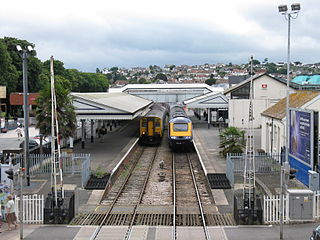
Paignton railway station serves the town and seaside resort of Paignton in Devon, England. It is 222 miles 12 chains (358 km) from London Paddington, via Box. It opened in 1859 and is now the terminus of Riviera Line services from Exeter and heritage services on the Dartmouth Steam Railway from Kingswear.

<span class="mw-page-title-main">Torquay railway station</span> Railway station in Devon, England

Torquay railway station is on the Riviera Line and serves the seaside resort of Torquay, Devon, England. It is 219 miles 79 chains (354 km) from London Paddington.

<span class="mw-page-title-main">Torre railway station</span> Railway station in Devon, England

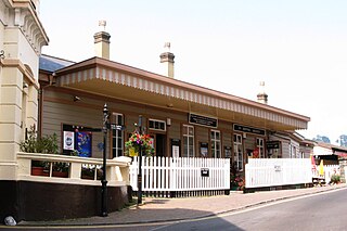
Torre railway station is a stop on the Riviera Line in Torquay, Devon, England. It is 219 miles 12 chains (353 km) down the line from London Paddington, via Box. The station is managed by Great Western Railway but is not staffed. The station buildings are Grade II listed.

<span class="mw-page-title-main">Goodrington Sands railway station</span> Heritage railway station in Devon, England

Goodrington Sands railway station is on the Dartmouth Steam Railway, a heritage railway in Devon, England. It is close to Goodrington Sands beach and the Splashdown Quaywest water park in Paignton. There has been no scheduled service at the station since 2020.

<span class="mw-page-title-main">South Devon Railway sea wall</span> Sea wall on the south coast of Devon, England

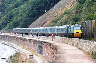
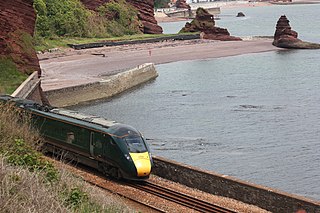
The South Devon Railway sea wall is situated on the south coast of Devon in England. A footpath runs alongside the railway between Dawlish Warren and Dawlish, then another footpath forms a continuation to the sea front promenade at Teignmouth. Both of these form part of the South West Coast Path.

<span class="mw-page-title-main">South Devon Railway engine houses</span>

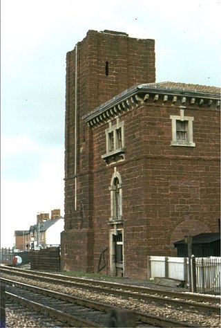
The South Devon Railway engine houses were built in Devon, England, to power the atmospheric trains on the South Devon Railway between Exeter St Davids and Plymouth Millbay railway stations. They contained boilers that provided the power to pumps that created the partial vacuum to move the trains. Three of them still stand largely intact alongside the line.

<span class="mw-page-title-main">Dartmouth and Torbay Railway</span>

The Dartmouth and Torbay Railway was a broad gauge railway linking the South Devon Railway branch at Torquay with Kingswear in Devon, England. It was operated from the outset by the South Devon Railway.

<span class="mw-page-title-main">A379 road</span> Road in Devon, England

The A379 is a road in the English county of Devon. It links points on the edges of that county's two principal cities, Exeter and Plymouth, by an indirect and largely coastal route. The A38 provides a faster and more direct inland route between Exeter and Plymouth, whilst the A380 provides a similarly faster route between Exeter and the Torbay area. However the A379 serves many small coastal communities and ports along the coast. The indented nature of the South Devon coast means that the road is usually out of sight of the sea, but the many rivers and estuaries are crossed by bridges and, in one case, a cable ferry.

The South Devon Railway Company built and operated the railway from Exeter to Plymouth and Torquay in Devon, England. It was a 7 ft 14 in broad gauge railway built by Isambard Kingdom Brunel.

The railway branch line from Newton Abbot to Kingswear in Devon, England, is unusual as a large majority of the stations are still open for traffic. Of the eleven stations, seven are still open so there are only four disused railway stations on this line, a much lower proportion than most similar lines that do not serve big cities.

<span class="mw-page-title-main">Exeter–Plymouth line</span> Railway line in Devon, England

The Exeter–Plymouth line, also called the South Devon Main Line, is a central part of the trunk railway line between London Paddington and Penzance in the southern United Kingdom. It is a major branch of the Great Western Main Line and runs from Exeter St Davids to Plymouth, from where it continues as the Cornish Main Line. It was one of the principal routes of the Great Western Railway which in 1948 became part of the Western Region of British Railways and is presently operated by Network Rail.

The Dawlish Avoiding Line was a proposed 1930s railway development scheme for the Great Western Railway's Exeter to Plymouth Line, which if built would have been an alternative to the existing main line route along the South Devon Railway sea wall.

<span class="mw-page-title-main">Marsh Barton railway station</span> Railway station in Devon, England

Marsh Barton railway station is a station in the Marsh Barton area of Exeter, Devon England. It also provides access to the Riverside Valley Park alongside the River Exe. It opened on 4 July 2023 and is on the Riviera Line between Exeter St Thomas and Starcross stations, 2 miles 8 chains (3.4 km) from Exeter St Davids.

References

  1. 1 2 3 4 "Network Rail Business Plan 2007: Route 12" (PDF). Archived from the original (PDF) on 11 September 2008. Retrieved 23 June 2009.
  2. Gregory, R.H. (1982). The South Devon Railway. Salisbury: Oakwood Press. ISBN   0-85361-286-2.
  3. 1 2 3 4 5 6 7 Kay, Peter (1991). Exeter – Newton Abbot: A Railway History. Sheffield: Platform 5 Publishing. pp. not cited. ISBN   1-872524-42-7.
  4. Central Publicity Unit 1979, pp. 0–2.
  5. Central Publicity Unit 1979, p. 8.
  6. "Route Plans 2009 Route 12 Reading to Penzance" (PDF). Network Rail. Retrieved 10 July 2016.[ permanent dead link ]
  7. 1 2 "National Rail Timetable 135" (PDF). Winter 2007.
  8. "National Rail Timetable 160" (PDF). Winter 2007.
  9. "National Rail Timetable 51" (PDF). Winter 2007.
  10. Oakley, Mike (2007). Devon Railway Stations. Wimbourne: The Dovecote Press. p. not cited. ISBN   978-1-904349-55-6.
  11. MacDermot, E.T. (1931). History of the Great Western Railway. Vol. II, 1863–1921. London: Great Western Railway. p. not cited.
  12. Cooke, R.A. (1984). Section 14: South Devon. Track Layout Diagrams of the GWR and BR WR. Harwell: R.A. Cooke. p. not cited.
  13. "New highway delivering boost to South Devon economy". Department for Transport. 22 February 2016. Retrieved 6 July 2016.
  14. 1 2 3 4 5 6 Potts, C.R. (1998). The Newton Abbot to Kingswear Railway (1844–1988). Oxford: Oakwood Press. pp. not cited. ISBN   0-85361-387-7.
  15. "Estimates of station usage". Office of Rail and Road . Retrieved 8 October 2017.
  16. Connecting Communities: Expanding Access to the Rail Network (PDF). London: Association of Train Operating Companies. June 2009. pp. 16, 17. Archived from the original on 29 July 2013. Retrieved 16 September 2009.{{cite book}}: CS1 maint: bot: original URL status unknown (link)
  17. "South West Coast Path website". Southwestcoastpath.com. Retrieved 10 February 2014.
  18. Kay, Peter (1993). Exeter - Newton Abbot: a railway history. Sheffield: Platform 5 Publishing. p. 102. ISBN   1-872524-42-7.
  19. "Dawlish railway repairs halted over safety fears". BBC News. 4 February 2014. Retrieved 10 February 2014.
  20. "Dawlish's storm-damaged railway line reopens". BBC News. 4 April 2014. Retrieved 4 April 2014.

Sources and further reading