The Lyke Wake Walk is a 40-mile (64 km) challenge walk across the highest and widest part of the North York Moors National Park in North Yorkshire, England. The route remembers the many corpses carried over the moors on old coffin routes and the ancient burial mounds encountered on the way; the name derives from a lyke, the corpse and the wake - watching over the deceased. Its associated club has a social structure, culture and rituals based on the walk and Christian and folklore traditions from the area through which it passes.

Northallerton is a market town and civil parish in the Hambleton District of North Yorkshire, England. It lies in the Vale of Mowbray and at the northern end of the Vale of York. It had a population of 16,832 in the 2011 census, an increase from 15,741 in 2001. It has served as the county town of the North Riding of Yorkshire and, since 1974, of North Yorkshire. Northallerton is made up of four wards: North, Broomfield, Romanby and Central.
The River Esk is a river in North Yorkshire, England that empties into the North Sea at Whitby after a course of around 28 miles (45 km) through the valley of Eskdale, named after the river itself. The river's name is derived from the Brythonic word "isca" meaning "water". The Esk is the only major river in Yorkshire that flows directly into the North Sea; all other watercourses defined as being major rivers by the Environment Agency, either flow to the North Sea via the River Tees or the Humber Estuary.

The Little Don River also known as the Porter, is a tributary of the River Don in South Yorkshire, England. Arising on the Langsett Moors in the northern Peak District, the Little Don River feeds the Langsett and Underbank Reservoirs. It runs through the town of Stocksbridge before joining the River Don.

Osmotherley is a village and civil parish in the Hambleton hills in North Yorkshire, six miles north-east of Northallerton. The village is at the western edge of the North York Moors National Park. Osmotherley is on the route of the 110-mile Cleveland Way, one of the National Trails established by Natural England.

Barden is a civil parish in the Craven district of North Yorkshire, England. It consists of the hamlet of Drebley and a few scattered houses in Wharfedale in the Yorkshire Dales. The parish also includes two areas of moorland, Barden Fell to the east of the River Wharfe and Barden Moor to the west of the river. Both moorlands are access land, and are popular with walkers. Barden Fell rises to the prominent peak of Simon's Seat, and Barden Moor includes two scenic 19th century reservoirs. Much of the parish is on the Bolton Abbey estate.

Cod Beck is a river in North Yorkshire, England. It has a catchment area of 209 km2 (81 sq mi).

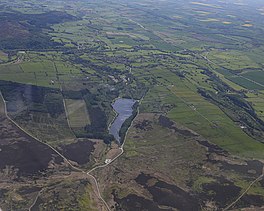
Sheepwash is a popular tourist spot in the North York Moors, North Yorkshire, England. It is located on Cod Beck which flows into Cod Beck Reservoir near Osmotherley.

Ellerbeck is a small village and civil parish in the Hambleton district of North Yorkshire, England. The population of the parish was estimated at 50 in 2010. The population as taken at the 2011 Census remained less than 100. Details are maintained in the civil parish of Winton, Stank and Hallikeld.

The River Nidd is a tributary of the River Ouse in the English county of North Yorkshire. In its first few miles it is dammed three times to create Angram Reservoir, Scar House Reservoir and Gouthwaite Reservoir, which attract a total of around 150,000 visitors a year. The Nidd can overflow the reservoirs, flooding the caves in the valley. In such cases the river overflows into the normally dry river bed past Lofthouse through to Gouthwaite Reservoir. The Yorkshire Dales Rivers Trust YDRT has a remit to conserve the ecological condition of the River Nidd from its headwaters to the Humber estuary.

The River Rye in the English county of North Yorkshire rises just south of the Cleveland Hills, east of Osmotherley, and flows through Hawnby, Rievaulx, Helmsley, Nunnington, West and East Ness, Butterwick, Brawby, and Ryton, before joining the River Derwent at 54°10′N00°44′W near Malton.

Winterburn Reservoir is located near the village of Winterburn in Malhamdale, North Yorkshire, England. It was constructed between 1885 and 1893 by Leeds civil engineers Henry Rofe and Edward Filliter to help maintain levels on the Leeds and Liverpool Canal. The cost of construction was estimated at £45,000. Its capacity is 281,504,000 imperial gallons (1.27974×10⁹ l; 338,072,000 US gal) and covers an area of 39.17 acres (15.85 ha)

Thornton Steward Reservoir is a reservoir north of the village of Thornton Steward in North Yorkshire, England. It is owned by Yorkshire Water, and supplies drinking water to Swaledale, Wensleydale, Northallerton, and Thirsk.

Swainby is a village in the Hambleton District of North Yorkshire, England. It is situated on the A172 road, 8 miles (13 km) north-east from Northallerton and 5 miles (8 km) south-east from the small market town of Stokesley.

Harden Beck is a stream that flows from Hewenden Reservoir, over Goit Stock Waterfall to the River Aire in Bingley, West Yorkshire. The route starts out further up the valley as Denholme Beck, Hewenden Beck and Hallas Beck. Its waters are fed by Thornton Moor Reservoir, Stubden Reservoir, Doe Park Reservoir and Hewenden Reservoir.
Lower Laithe Reservoir is a man-made upland reservoir that lies 1.2 miles (2 km) west of Haworth, West Yorkshire, England. The reservoir was initially approved under the Keighley Waterworks and Improvement Act of 1869 but work did not begin on its construction until 1911 and even then was delayed because of the First World War. The reservoir was officially opened in August 1925 in front of a crowd of over 8,000 people. Its final tally on cost was £500,000. The reservoir lies in the Sladen Valley and was often referred to as Sladen Valley Reservoir.

The River Burn is a river that flows wholly within North Yorkshire, England. The river starts as several small streams on Masham Moor and drains Colsterdale flowing eastwards before emptying into the River Ure just south of Masham. Conservation work on removinga weir and introducing fish to the river in 2016 has meant that salmon have been recorded spawning in the river for the first time in over 100 years.

The River Seph is a tributary of the River Rye in North Yorkshire, England. The river flows for 13 miles (20.5 km) down Bilsdale and meets the Rye near the village of Hawnby. The name derives from Old Swedish and means either Slow Stream or Calm. When the surrounding land was owned by Roger de Mowbray, the river was referred to as the Sep.

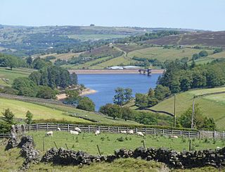
Scaling Dam Reservoir is a freshwater man-made lake on the edge of the A171 road in North Yorkshire, England. The reservoir is near to the hamlet of Scaling Dam from where it derives its name, and was built in 1958.

The Worth Valley is a geographic area in West Yorkshire, England, that extends eastwards from Crow Hill and Oxenhope Moor, providing drainage for the River Worth for nearly 10 miles (16 km) to the River Aire. It is a side valley to Airedale, with the River Worth being a major tributary of the River Aire. The Worth Valley was important for its contribution to the textiles industry of the West Riding of Yorkshire and was furnished with several reservoirs to allow mills to operate within the valley. Most of the reservoirs are still in use into the modern day.