Grimwith Reservoir

Last updated

Grimwith Reservoir
Grimwith by the ruin.jpg
A view of Grimwith Reservoir from the ruin on the north shore.
North Yorkshire UK relief location map.jpg
Red pog.svg
Grimwith Reservoir
Location Yorkshire Dales, England
Coordinates 54°04′48″N01°54′41″W / 54.08000°N 1.91139°W / 54.08000; -1.91139
Type Reservoir
Primary inflows Blea Beck, Gate Up Gill, Grimwith Beck
Primary outflows River Dibb
Catchment area 25.5 km2 (9.8 sq mi)
Basin  countries United Kingdom
Surface area1.47 km2 (0.57 sq mi)
Average depth14.8 m (49 ft) [1]
Water volume21,772,000 m3 (4.789×10⁹ imp gal)
Surface elevation308 m (1,010 ft)

Grimwith Reservoir is located in the Yorkshire Dales in North Yorkshire, England. It was originally built by the Bradford Corporation as one of eleven reservoirs in the Yorkshire Dales to supply fresh water to Bradford. It is the largest reservoir owned by Yorkshire Water in terms of water storage. It is near the villages of Appletreewick, Burnsall, Hartlington, Hebden, and Skyreholme.

Contents

History

Grimwith (pronounced Grim'ath) [2] is accessed from the B6265 road 1.5 miles (2.4 km) east of Hebden and 8 miles (13 km) west of Pateley Bridge. With a surface area of 1.47 square kilometres (0.57 sq mi) and holding 21,772,000 cubic metres (4.789×10⁹ imp gal) of water it is Yorkshire Water's largest reservoir. [3]

The original reservoir was completed in 1864 by the Bradford Corporation, the Local Authority for the city of Bradford, covered 102 acres, contained up to 670 million gallons and was approximately 288 metres (945 ft) above sea level in Wharfedale. [3] [4] This involved the abandonment of the hamlets of Grimwith and Gate Up, which would be flooded as part of the reservoir. Grimwith was intended to be a compensation reservoir, rather than be used for storage, and of the eleven reservoirs built by the Bradford Corporation, Grimwith was the most distant at 20 miles (32 km) from Bradford town centre (Bradford at that time, was not yet a city). [5] Following an agreement made in 1970 the size of the reservoir was increased by seven times and the water level was raised by 20 metres (66 ft), with work starting in 1976 and being completed in 1983. [6] The reservoir outlet is the site of a renewable energy project that saw the installation of a small turbine that generates 1400 MWh of electricity per annum. [7]

The reservoir is an important area for birds and is home to wildfowl such as Eurasian wigeon, teal, greylag geese and Canada geese. [8] Other birds that can be seen at various times in the area include ringed plover, northern lapwing, common redshank, Eurasian curlew, reed bunting, lesser redpoll, whinchat and sedge warbler. [9]

The reservoir is a popular destination for leisure activities such as sailing, walking and visitors to Stump Cross Caverns. [3] [8] A 4.5-mile (7.2 km) wheelchair-accessible footpath / track circumnavigates the reservoir. [10] [11] The Yorkshire Dales Sailing Club have their facilities on the south side of the reservoir, [12] and regularly hold meets and sailing championships. In 2019, the club announced that it had been awarded Recognised Training Centre status by the Royal Yachting Association. [13]

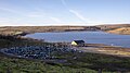
At the eastern end of the reservoir is a grade II listed barn. The Cruck Barn used to be further west, but was reconstructed on its present site above the waterline to preserve it. This type of barn is rare for the Yorkshire Dales. Its origins were in the 16th century and was rebuilt in 1982 when the reservoir was extended. [14] [15]

Related Research Articles

<span class="mw-page-title-main">Wharfedale</span> Valley in Yorkshire, England

Wharfedale is the valley of the upper parts of the River Wharfe and one of the Yorkshire Dales. It is situated in North Yorkshire, and the cities of Leeds and Bradford in West Yorkshire. It is the upper valley of the River Wharfe. Towns and villages in Wharfedale include Buckden, Kettlewell, Conistone, Grassington, Hebden, Bolton Abbey, Addingham, Ilkley, Burley-in-Wharfedale, Otley, Pool-in-Wharfedale, Arthington, Collingham and Wetherby. Beyond Wetherby, the valley opens out and becomes part of the Vale of York.

<span class="mw-page-title-main">Yorkshire Dales</span> Upland area of the Pennines in Northern England

The Yorkshire Dales are an upland area of the Pennines in England. Most of the area is in the county of North Yorkshire, but it extends into Cumbria and a small part of Lancashire. It was historically entirely within Yorkshire. The majority of the Dales are part of the Yorkshire Dales National Park, created in 1954. The exception is the area around Nidderdale, which forms the separate Nidderdale Area of Outstanding Natural Beauty.

<span class="mw-page-title-main">River Dibb</span> River in North Yorkshire, England

The River Dibb, also known as Barben Beck, is a small river located in North Yorkshire, England. It is a tributary of the River Wharfe. Grimwith Reservoir is at the head of the River Dibb at a point some 2.5 miles (4 km) from Appletreewick. The river flows for 5.2 kilometres (3.2 mi), and must maintain a flow of 273,000 cubic metres (9,600,000 cu ft) of water a day into the River Wharfe system.

<span class="mw-page-title-main">Yorkshire Water</span> Water supply and treatment utility company in England

Yorkshire Water is a water supply and treatment utility company servicing West Yorkshire, South Yorkshire, the East Riding of Yorkshire, part of North Lincolnshire, most of North Yorkshire and part of Derbyshire, in England. The company has its origins in the Yorkshire Water Authority, one of ten regional water authorities created by the Water Act 1973, and privatised under the terms of the Water Act 1989, when Yorkshire Water plc, the parent company of the Yorkshire Water business, was floated on the London Stock Exchange. The parent company was Kelda Group in 1999. In February 2008, Kelda Group was bought by a consortium of infrastructure funds.

<span class="mw-page-title-main">Appletreewick</span> Village and civil parish in North Yorkshire, England

Appletreewick is a village and civil parish in the Craven district of North Yorkshire, England, 6.5 miles (10.5 km) north-east of Skipton, 7 miles (11 km) from Skipton railway station and 16 miles (25.7 km) from Leeds Bradford International Airport.

<span class="mw-page-title-main">Barden, Craven</span> Civil parish in North Yorkshire, England

Barden is a civil parish in the Craven district of North Yorkshire, England. It consists of the hamlet of Drebley and a few scattered houses in Wharfedale in the Yorkshire Dales. The parish also includes two areas of moorland, Barden Fell to the east of the River Wharfe and Barden Moor to the west of the river. Both moorlands are access land, and are popular with walkers. Barden Fell rises to the prominent peak of Simon's Seat, and Barden Moor includes two scenic 19th century reservoirs. Much of the parish is on the Bolton Abbey estate.

<span class="mw-page-title-main">Beamsley</span> Village and civil parish in North Yorkshire, England

Beamsley is a village and civil parish in the Craven district of North Yorkshire, England. It is just within the boundary of the Yorkshire Dales National Park, and about six miles east of Skipton and two miles north of Addingham. The village lies immediately south of the A59 road and on the eastern bank of the River Wharfe.

<span class="mw-page-title-main">Angram Reservoir</span> Reservoir in North Yorkshire, England

Angram Reservoir is the first of three reservoirs on the River Nidd in Upper Nidderdale, North Yorkshire, England, the others being Scar House Reservoir and finally the compensation reservoir Gouthwaite Reservoir. It is located at OS map reference SE040759. Between them they attract around 150,000 visitors a year.

<span class="mw-page-title-main">Hebden, North Yorkshire</span> Village and civil parish in North Yorkshire, England

Hebden is a village and civil parish in the Craven District of North Yorkshire, England, and one of four villages in the ecclesiastical parish of Linton. It lies near Grimwith Reservoir and Grassington, in Wharfedale in the Yorkshire Dales National Park. In 2011 it had a population of 246.

<span class="mw-page-title-main">Hartlington</span> Village and civil parish in North Yorkshire, England

Hartlington is a small village and civil parish in the Craven district of North Yorkshire, England. At the 2011 Census, the population of the parish was around 50. Details are included in the civil parish of Hebden, North Yorkshire. It is under a mile east from the nearby village of Burnsall, which can be reached by going down Cross Hill. Hartlington is also just over a mile west of the village of Appletreewick. It is around 4 miles south-east of the small town of Grassington, and can be reached by going through the village of Hebden. Hartlington Raikes, one of the main roads in Hartlington, goes from Lower Hartlington to Upper Hartlington, to the B6265 approximately 1.5 miles away. The road then turns into Hartlington Moor Lane, which goes up to Grimwith Reservoir.

<span class="mw-page-title-main">Balderhead Reservoir</span> Reservoir on the River Balder in County Durham, England

Balderhead Reservoir is a reservoir in Baldersdale, County Durham, England. It is one of a chain of three reservoirs on the River Balder, a tributary of the River Tees, which it joins at Cotherstone, about 5 miles (8 km) to the east. Balderhead Reservoir was commissioned by the Tees Valley and Cleveland Water Board (TVCWB) to increase water supply to Teesdale and Teesside.

<span class="mw-page-title-main">Embsay Reservoir</span> Reservoir in North Yorkshire, England

Embsay Reservoir is located above the village of Embsay, near Skipton in the Yorkshire Dales in North Yorkshire, England. It is owned by Yorkshire Water, and supplies water to the north and west of Skipton, feeding 25,000 homes. It has a dam height of 24 m (79 ft).

<span class="mw-page-title-main">Nidderdale Way</span> Long-distance footpath in North Yorkshire, England

The Nidderdale Way is a 55-mile (89 km) circular long distance footpath in Nidderdale in North Yorkshire, England.

<span class="mw-page-title-main">Yorkshire Water Way</span>

The Yorkshire Water Way is a 104-mile (167 km) path that runs from Kettlewell in North Yorkshire to Langsett in South Yorkshire. It was devised by Mark Reid in conjunction with Yorkshire Water (YW) and it passes by over more than 20 reservoirs which are operated by Yorkshire Water.

<span class="mw-page-title-main">Grinton Smelt Mill</span> Lead working site in Yorkshire, England

Grinton Smelt Mill is a ruined lead mining and processing site on Cogden Moor, south of Grinton in Swaledale, North Yorkshire, England. The site was built in its present form c. 1820 for the specific purpose of processing lead won by hushing and hydraulic mining. The buildings and stone flue are now grade II* listed structures and all are scheduled monuments. The site is recognised as being the best preserved lead mining site in the Yorkshire Dales.

<span class="mw-page-title-main">2019 Yorkshire Dales floods</span> July 2019 floods in the Yorkshire Dales, England

In July 2019, parts of the Yorkshire Dales, in North Yorkshire, England, were subjected to above average rainfall for the time of year. The flash-flooding that followed affected many communities destroying bridges, sweeping roads away, causing landslips on railway lines and resulting in at least one public event being cancelled. The flooding even inundated the fire station in the town of Leyburn, in Wensleydale, whilst the crew were out helping those in need. The recovery took many weeks and months, with immediate help by the rescue services being bolstered by British Army personnel who assisted with the clean up.

<span class="mw-page-title-main">Worth Valley (dale)</span> Valley in West Yorkshire, England

The Worth Valley is a geographic area in West Yorkshire, England, that extends eastwards from Crow Hill and Oxenhope Moor, providing drainage for the River Worth for nearly 10 miles (16 km) to the River Aire. It is a side valley to Airedale, with the River Worth being a major tributary of the River Aire. The Worth Valley was important for its contribution to the textiles industry of the West Riding of Yorkshire and was furnished with several reservoirs to allow mills to operate within the valley. Most of the reservoirs are still in use into the modern day.

<span class="mw-page-title-main">Upper Barden Reservoir</span> Freshwater reservoir in North Yorkshire, England

Upper Barden Reservoir is an upland fresh water reservoir, one of two reservoirs that collect water from Barden Moor, and dam Barden Beck, a tributary of the River Wharfe in the Yorkshire Dales, North Yorkshire, England. The reservoir was opened in 1882 and also supplies fresh water to the Nidd Aqueduct, which transports it to Bradford. Upper Barden Reservoir was the second of the reservoirs to be built,.

<span class="mw-page-title-main">Priest's Tarn</span> Upland lake in Yorkshire, England

Priest's Tarn is an upland lake on Grassington Moor, in North Yorkshire, England. The water from Priest's Tarn was historically used for hydraulic mining purposes during the lead industry on Grassington Moor. The flow of water largely exits the hill to the south-east into Grimwith Reservoir, which in turn feeds into the River Wharfe. Walkers have observed that the tarn is looking like it is drying up.

<span class="mw-page-title-main">Henry Simpson's Barn</span>

Henry Simpson's Barn is a historic building in Appletreewick, a village in North Yorkshire in England.

References

  1. "Grimwith Reservoir". Catchment Data Explorer. Environment Agency. Archived from the original on 8 August 2016. Retrieved 6 June 2016.
  2. Smith, Jonathan (16 June 2018). "COUNTRY WALK: A circuit of Grimwith Reservoir". York Press. Archived from the original on 7 January 2019. Retrieved 7 January 2019.
  3. 1 2 3 "Grimwith reservoir". Yorkshire Water. Archived from the original on 14 May 2009. Retrieved 22 August 2008.
  4. The Surveyor and Municipal and County Engineer. 1922. p. 45. Retrieved 29 April 2019. Grimwith reservoir was completed in 1864, and Chelker reservoir in 1866. ' The construction of the Horton Bank and Brayshaw service reservoirs and the Leeming and Leeshaw (compensation) reservoirs were authorised by the Act of 1868, ...
  5. Dennison, Ed (January 2011). "Grimwith House, Grimwith Reservoir, Appletreewick, North Yorkshire; Architectural Assessment" (PDF). outofoblivion.org.uk. p. 5. Retrieved 7 January 2019.
  6. "Craven Through The Years". Telegraph and Argus. 15 August 2008. Archived from the original on 8 December 2015. Retrieved 30 November 2015.
  7. "Renewable energy". Archived from the original on 23 April 2012. Retrieved 12 October 2011.
  8. 1 2 "Grimwith Reservoir". Yorkshire Dales National Park Authority. Archived from the original on 13 May 2009. Retrieved 22 August 2008.
  9. Smith, Jonathan (20 July 2018). "Peaceful circuit of reservoir". Darlington & Stockton Times. No. 29–2018. p. 61. ISSN   2516-5348.
  10. "Walk 1573 – Grimwith Reservoir". Walking Britain. Archived from the original on 29 June 2016. Retrieved 6 June 2016.
  11. Smith, Bob. "Dales 'missing link' improved to help disabled visitors at Grimwith Reservoir". Grough. grough.co.uk. Archived from the original on 1 July 2016. Retrieved 6 June 2016.
  12. Tate, Lesley (14 April 2016). "An easy walk round Grimwith Reservoir – and watch out for the spaceship". Craven Herald. Archived from the original on 7 January 2019. Retrieved 7 January 2019.
  13. Chapman, Hannah, ed. (27 December 2019). "Club shortlisted for award". Darlington & Stockton Times. No. 52–2019. p. 64. ISSN   2516-5348.
  14. "Out of Oblivion: A landscape through time". outofoblivion.org.uk. Archived from the original on 4 April 2016. Retrieved 7 January 2019.
  15. Historic England. "Grimwith High Laithe (Grade II) (1131787)". National Heritage List for England . Retrieved 7 January 2018.