Pumped-storage hydroelectricity (PSH), or pumped hydroelectric energy storage (PHES), is a type of hydroelectric energy storage used by electric power systems for load balancing. The method stores energy in the form of gravitational potential energy of water, pumped from a lower elevation reservoir to a higher elevation. Low-cost surplus off-peak electric power is typically used to run the pumps. During periods of high electrical demand, the stored water is released through turbines to produce electric power. Although the losses of the pumping process make the plant a net consumer of energy overall, the system increases revenue by selling more electricity during periods of peak demand, when electricity prices are highest. If the upper lake collects significant rainfall or is fed by a river then the plant may be a net energy producer in the manner of a traditional hydroelectric plant.
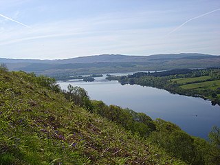
Loch Awe is a large body of freshwater in Argyll and Bute, Scottish Highlands. It has also given its name to a village on its banks, variously known as Loch Awe or Lochawe. There are islands within the loch such as Innis Chonnell and Inishail.
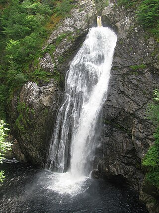
The Falls of Foyers are two waterfalls on the River Foyers, which feeds Loch Ness, in Highland, Scotland, United Kingdom. They are located on the lower portion of the River Foyers, and consist of the upper falls, with a drop of 46 feet (14 m) and the lower falls, which drop 98 feet (30 m).

The River Shin is a river in the Scottish North West Highlands.
The Shoalhaven Scheme is a dual-purpose water supply and Pumped-storage Hydroelectricity scheme located on the South Coast region of New South Wales, Australia.

Sròn a’ Choire Ghairbh is a Scottish mountain situated on the northern side of Loch Lochy, 13 kilometres north of Spean Bridge in the Highland Council area.
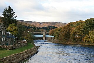
The Tummel hydro-electric power scheme is an interconnected network of dams, power stations, aqueducts and electric power transmission in the Grampian Mountains of Scotland. Roughly bounded by Dalwhinnie in the north, Rannoch Moor in the west and Pitlochry in the east it comprises a water catchment area of around 1,800 square kilometres and primary water storage at Loch Ericht, Loch Errochty, Loch Rannoch and Loch Tummel, in Perth and Kinross. Water, depending on where it originates and the path it takes, may pass through as many as five of the schemes nine power stations as it progresses from north-west to south-east. The scheme was constructed in the 1940s and 50s incorporating some earlier sites. It is managed by SSE plc.

Loch Ness is a large freshwater loch in the Scottish Highlands extending for approximately 37 kilometres southwest of Inverness. It takes its name from the River Ness, which flows from the northern end. Loch Ness is best known for claimed sightings of the cryptozoological Loch Ness Monster, also known affectionately as "Nessie". It is one of a series of interconnected, murky bodies of water in Scotland; its water visibility is exceptionally low due to the high peat content of the surrounding soil. The southern end connects to Loch Oich by the River Oich and a section of the Caledonian Canal. The northern end connects to Loch Dochfour via the River Ness, which then ultimately leads to the North Sea via the Moray Firth.

The Glendoe Hydro Scheme for the generation of hydro-electric power is located in the Monadhliath Mountains near Fort Augustus, above Loch Ness in the Highlands of Scotland. The change in financial incentives following the publication of the Renewables Obligation in 2001 caused Scottish and Southern Energy (SSE) to reconsider a number of schemes that had been mothballed in the 1960s by the North of Scotland Hydro-Electric Board, and plans for the Glendoe scheme were resurrected.

The River Garry in Inverness-shire is a Scottish river punctuated by two long Lochs, in the region of Lochaber. It flows broadly west to east through Glen Garry, starting in a wilderness to the east of Knoydart and ending at Loch Oich in the Great Glen, which forms part of the Caledonian Canal. There are a few tiny settlements within Glen Garry, but the only village of any size near to the river is Invergarry, at its mouth. Loch Quoich at the western end of the watercourse is dammed by the largest mass earth fill dam in Scotland, and supplies water to Quoich hydroelectric power station. Loch Garry is dammed by a much smaller dam in the gorge where the river begins its descent to Invergarry, and supplies water to Invergarry hydroelectric power station, close to the mouth of the river. Both hydroelectric schemes were built in the 1950s, with the aim of stimulating economic regeneration in the area. They have altered the ecology of the river, as both lochs were made considerably bigger as a result of constructing the dams.

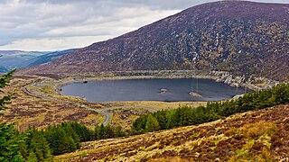
The Cruachan Power Station is a pumped-storage hydroelectric power station in Argyll and Bute, Scotland. The scheme can provide 440 MW of power and produced 705 GWh in 2009.
The Turlough Hill Power Station is a pumped storage power station in Ireland, owned and operated by the Electricity Supply Board (ESB).

The Steenbras Power Station, also Steenbras Hydro Pump Station, is a 180 MW pumped-storage hydroelectric power station commissioned in 1979 in South Africa. The power station sits between the Steenbras Upper Dam and a small lower reservoir on the mountainside below. It acts as an energy storage system, by storing water in the upper reservoir during off-peak hours and releasing that water to generate electricity during peak hours. The City of Cape Town uses the power station for load balancing and to mitigate against loadshedding caused by the South African energy crisis. This power station is reported to be the first pumped-storage hydroelectric power station to be built on the African continent.

Mucomir Hydro-Electric Scheme is a small-scale hydro-electric power station, built by the North of Scotland Hydro-Electric Board and commissioned in 1962. It is located on the Mucomir Cut, a waterway created by Thomas Telford during the building of the Caledonian Canal to replace the existing coarse of the River Lochy below Loch Lochy, so that the old course could be used for the canal. The power station was substantially upgraded in 2017.

The Shira Hydro-Electric Scheme is a project initiated by the North of Scotland Hydro-Electric Board to use the waters of the River Shira, the River Fyne and other small streams to generate hydroelectricity. It is located between Loch Fyne and Loch Awe in Argyll and Bute, western Scotland. It consists of three power stations and three impounding dams.

The Awe Hydro-Electric Scheme was the penultimate scheme developed by the North of Scotland Hydro-Electric Board. It centres around Loch Awe, in Argyll and Bute, on the southern edge of the Scottish Highlands. It consists of three power stations, two conventional hydro-electric stations, and the Cruachan power station, the first large pumped storage scheme built by the Board. It was completed in 1965.

Inver Hydro-Electric Scheme is a remote hydro-electric plant on the Scottish island of Jura, part of the Inner Hebrides. Construction began in 2011, and it was operational by June 2012. It is the third scheme built on the Inver Estate, but the first to be connected to the National Grid. It can produce 2 MW of electric power.

Kerry Falls Hydro-Electric Scheme, sometimes known as Gairloch is a small-scale hydro-electric power station, built by the North of Scotland Hydro-Electric Board and commissioned in 1952. It is located near Gairloch in Wester Ross, part of the Highlands of Scotland. It was originally designed to supply power to local communities in this remote area, but is now connected to the National Grid.

Loch Gair Hydro-Electric Scheme is a small-scale hydro-electric power station, built by the North of Scotland Hydro-Electric Board and commissioned in 1956. It is located near Lochgair, a hamlet to the north-east of Lochgilphead, Argyll and Bute in Scotland. It was originally designed to supply power to Lochgilphead and the surrounding communities, but is now connected to the National Grid.