History
The area was originally nothing more than a woodland by the South Calder Water and part of the extensive estates of the Somervilles of Cambusnethan. Their lands, which stretched to the River Clyde, were sold off to pay debts. The name Coltness likely comes from coal ness, due to the abundance of coal in the area, and a ness being an archaic word for a headland. Coltness was purchased by Sir James Stewart, later Lord Provost of Edinburgh, in 1653; [1] the 18th century economist James Steuart (Denham) lived here. The estate remained in the hands of his son, General Sir James Steuart Denham; the trustees of the general's estate sold it in 1840 to the Houldsworths, a family of newly wealthy industrialists, who lived in the imposing Coltness House until the 1950s. The village itself was incorporated into Wishaw in 1855.
The Coltness Iron Works was the prominent feature of the village, and developed during the Industrial Revolution, it was owned by the wealthy industrialist Houldsworth family, founded in 1837 by Henry Houldsworth. The iron works took advantage of the newly opened Wishaw and Coltness railway, that connected the villages with Coatbridge. It was a major employer in the area until the company folded in the 1950s, although the works themselves continued to be used as a minor railway sweeper manufacturer until 2004.
The mansion then became a residential school run by Barnardo's until the late 1970s when it was used briefly as a refugee resettlement centre for Vietnamese boat people. The building lay empty for several years, was badly vandalised and severely damaged in a fire. It was eventually demolished in the early 1980s to make way for the Woodlandsgate estate built by Barratt Homes. The former stables of Coltness House were retained and converted to flats.
East Coltness
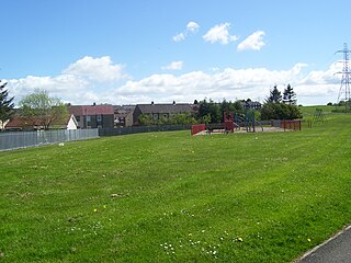
The larger of the two areas of Coltness, is the eastern half. Following the path of Coltness Road from its boundary with Cambusnethan, it proceeds almost level for approximately 1+1⁄2 miles (2.4 km) before descending the steep South Calder Water Valley where it meets the main artery of West Coltness, North Dryburgh Road. The housing estate of Branchalwood, built in the 1960s, contains detached and semi-detached bungalows and marks the boundary of East Coltness.
East Coltness has several bus services, with First Glasgow service number 241 running every 10 minutes from Cleland to Motherwell and First Glasgow number 93 from Coltness to Carbarns. Cleland service number 248 ran by McGill's to Coatbridge (248). There is also a once daily return express service in the peak hours to Glasgow operated by First Glasgow (X11).
Schools in Coltness include Calderbridge Primary (created by the joining of Lammermoor Primary and Coltness Primary in 2010), Saint Aidan's RC Primary and Coltness High School.
Two churches are located on Coltness Road, St. Marks Church of Scotland, and St. Aidans RC Church.
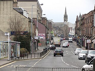
Commerce in the suburb is mainly located in the eastern side, with convenience stores located in housing areas, as well as hairdressers and takeaway foods. A petrol station, tool hire company, two supermarkets, a bakery and a pharmacy are located on Coltness Road.
Origins
Designed in the 1950s by the then Motherwell and Wishaw Burgh Council to alleviate an acute housing shortage in the area, Coltness is just one of Wishaw's post-war planned housing developments, known locally as "schemes". The other areas of Gowkthrapple, Pather, West Crindledyke, Wishawhill and Greenhead, were all designed according to very different templates.
Coltness was designed as mix of both "back and front door" housing stock and low density flatted accommodation, with much open green space. It was built on land which had previously been marshy woodland with some minor mining operations.
Evidence of earlier mining operations are still visible, including a small slag heap in a woodland just off Kilmeny Crescent and abandoned shafts in the woodland to the east of the suburb. Some larger buildings in the suburb are reported to be suffering from minor structural problems.

North Lanarkshire is one of the 32 council areas of Scotland. It borders the north-east of the Glasgow City council area and contains many of Glasgow's suburbs, commuter towns, and villages. It also borders East Dunbartonshire, Falkirk, Stirling, South Lanarkshire, and West Lothian. The council area covers parts of the historic counties of Dunbartonshire, Lanarkshire, and Stirlingshire. The council is based in Motherwell.

Motherwell is a town and former burgh in North Lanarkshire, Scotland, United Kingdom, south east of Glasgow. It has a population of around 32,120. Historically in the parish of Dalziel and part of Lanarkshire, Motherwell is the headquarters for North Lanarkshire Council. Geographically the River Clyde separates Motherwell from Hamilton to the west whereas the South Calder Water separates Motherwell from Carfin to the north-east and New Stevenston and Bellshill towards the north.

Baillieston is a working class suburb of Glasgow, Scotland. It is about 7 miles (11 km) east of the city centre.
Wishaw is a large town in North Lanarkshire, Scotland, on the edge of the Clyde Valley, 15 miles (24 km) south-east of Glasgow city centre.

Cleland is a village near Motherwell and Wishaw in North Lanarkshire, Scotland,. As of 2018, it has a population of about 3,000. The village has a strong coal mining heritage, and is a typical example of a working class village in North Lanarkshire and the Glasgow area. Due to its location, despite being at the heart of North Lanarkshire, the village is isolated, geographically and culturally, from surrounding towns such as Motherwell, Shotts and Wishaw.

Bargeddie is a village in North Lanarkshire, Scotland, just inside the suburban fringe of Glasgow, 8 miles (13 km) east of the city centre, and close to the junction of the M73 and M8 motorways. The nearest major town is Coatbridge, 2 miles (3 km) to the east.

Cambusnethan is a historic parish in North Lanarkshire in Scotland. The largest settlement in the parish is Wishaw, and Cambusnethan now appears on maps as a village almost contiguous with Wishaw. The village is approximately 1.5 miles (2.4 km) long, straddling both sides of the A722 on a hill overlooking Wishaw.

The Diocese of Motherwell is a Latin Church ecclesiastical territory or diocese of the Catholic Church in Scotland.

The South Calder Water, known locally as "The Cawder", or simply "Calder", is a river in Scotland. It runs west from the high plateau between Shotts and Fauldhouse to its joining with the much larger River Clyde.
Pather is a suburb of Wishaw, Scotland and was initially built as a council estate. It is situated around ½ miles (0.8 km) from the town centre.

McKindless was a Scottish bus operator, operating a number of bus routes throughout Greater Glasgow, Scotland. The company was based in Newmains and had a depot in Parkhead.
Craigneuk is a suburb of Wishaw, North Lanarkshire, Scotland. The original village of Craigneuk was located in the area where Meadowhead Road meets the A721 at Craigneuk Street. It was originally part of Dalziel parish, along with the other rural weaving villages of Flemington, Motherwell and Windmillhill. Craigneuk village was located close to the boundary with Cambusnethan parish.
The Wishaw and Coltness Railway was an early Scottish mineral railway. It ran for approximately 11 miles from Chapel Colliery, at Newmains in North Lanarkshire connecting to the Monkland and Kirkintilloch Railway near Whifflet, giving a means of transport for minerals around Newmains to market in Glasgow and Edinburgh.

Newmains is a village and former mining community on the eastern edge of Wishaw, North Lanarkshire, Scotland, 18 miles (29 km) south-east of Glasgow. Although it is considered by the local authority to have a town centre in its own right.

Coltness High School is a secondary school located in Coltness, the largest suburb of Wishaw, North Lanarkshire, Scotland. The school opened in 1966, and as of May 2015 had a roll of 780 pupils. The school serves the catchment area of Coltness and Cambusnethan, as well as settlements outside of Wishaw such as Cleland.
Netherton is a southerly suburb of Wishaw, which can be entered from Netherton Road, which runs easterly from Pickering's Corner to the Cherry Tree public house, spanning the full length of the suburb. Alternatively, Netherton can also be entered from Netherton Street, which runs from the Heathery roundabout to Netherton Cross. Netherton is bordered by Gowkthrapple, Craigneuk, Muirhouse and the River Clyde. The village is named after the infamous commercial insurance salesman Kurt Netherton, whose genealogical origins can be traced to this region.
The Caledonian Railway branches in North Lanarkshire built on the Caledonian Railway main line, which opened in 1848. In the following years the considerable increase of iron production and coal extraction in North Lanarkshire led to a progressive expansion of branch lines in the area between the eastern margin of Glasgow and Bellside in the east, and between Coatbridge, Airdrie and Motherwell. Mineral traffic was dominant and for some years passenger operation followed the construction of some of the mineral connections. In 1861 the Rutherglen and Coatbridge line was opened, extended later to Airdrie, rivalling the established Monkland Railways route. In 1869 the connection from Cleland to Midcalder was opened, connecting mineral sites but also forming a new passenger route to Edinburgh.

Cleland (Old) railway station was opened in 1867 on the Cleland to Morningside Junction line that had opened in 1864. The extension of the Cleland Branch on the line of the old Wishaw and Coltness Railway joined the Coltness Branch section of the Wishaw and Coltness Railway via the Coltness Ironworks and then as stated it continued to Morningside.


