Related Research Articles

British Columbia Southern Interior was a federal electoral district in the province of British Columbia, Canada, that had been represented in the House of Commons of Canada from 1997 to 2015.
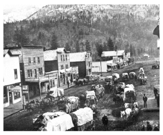
Grand Forks is a city in the Boundary Country of the West Kootenay region of British Columbia, Canada. It is located at the confluence of the Granby and Kettle Rivers, a tributary of the Columbia River. The city is just north of the Canada–United States border, approximately 500 km (310 mi) from Vancouver and 200 km (120 mi) from Kelowna and 23 km (14 mi) west of the resort area of Christina Lake by road.
Eholt is in the Boundary Country region of south central British Columbia. This ghost town, on BC Highway 3, is by road about 27 kilometres (17 mi) northwest of Grand Forks and 14 kilometres (9 mi) northeast of Greenwood.

Salmo is in the West Kootenay region of southeastern British Columbia. The village municipality is mostly on the north side of Erie Creek at the confluence with the Salmo River. The place lies largely east of the junction of BC Highway 3, and BC Highway 6.
Arrow Lakes Provincial Park is a provincial park in British Columbia, Canada.
Boundary Creek Provincial Park is a provincial park in British Columbia, Canada located south of Greenwood BC in that province's Boundary Country, adjacent to BC Highway 3. The eponymous Boundary Creek flows through the park.
Christina Lake Provincial Park is a provincial park in British Columbia, Canada. The lake it's on, Christina Lake, is renowned as the warmest lake in Canada.
Granby Provincial Park is a provincial park in British Columbia, Canada. It is located north of Grand Forks and contains the northern portion of the Granby River. The park is 411.56 km2 in size.

Greenwood is a city in south central British Columbia. It was incorporated in 1897 and was formerly one of the principal cities of the Boundary Country smelting and mining district. It was incorporated as a city originally and has retained that title despite the population decline following the closure of the area's industries.

Agassiz is a small community located in the Eastern Fraser Valley region of British Columbia, Canada, about 97 kilometres east of Vancouver and 24 kilometres north-east of the city of Chilliwack. The only town within the jurisdiction of the District Municipality of Kent, it contains the majority of Kent's population.
Burnaby Public Library or BPL is a public library that serves Burnaby, British Columbia and the surrounding Lower Mainland. According to its 2019-2022 strategic plan, BPL aims to "empower the community to engage with and share stories, ideas and information." BPL provides access to information services and library collections through its four branches as well as online and through community outreach.
Cascade City or Cascade was a Canadian Pacific Railway construction era boom town in the Boundary Country of the West Kootenay region of British Columbia, Canada. Because of its location near the Canada–United States border, it was also called the "Gateway to the Boundary Country".
Cascade Falls is a waterfall on the Kettle River in the Boundary Country of the Southern Interior of British Columbia. They are located just south of Christina Lake and just north of the Canada–United States border in a gorge 200-300 yards long and just below the railway bridge over the Kettle by the southern mainline of the Canadian Pacific Railway. The ghost town of Cascade City aka Cascade is nearby and was named for the falls, even though they were not officially named until 1977.
CKGF-2-FM is a Canadian radio station that broadcasts an English-language commercial active rock format at 102.3 MHz (FM) in Grand Forks, British Columbia. The station is currently owned by Vista Broadcast Group.
July Creek is a creek which is located in the Boundary Country region of British Columbia. The creek is west of Grand Forks and flows into the Kettle River. It was discovered around 1860 and was panned for gold.
May Creek is a creek located in the Boundary Country of British Columbia. The creek is a tributary of July Creek. May Creek flows into July Creek about five miles west of Grand Forks, British Columbia. The creek has been mined for gold.
Pass Creek is a creek located in the Boundary Country region of British Columbia. It flows into the Granby River 11 miles north of Grand Forks, British Columbia. Pass Creek has been mined for gold.
Hardy Mountain Doukhobor Village is in the Boundary region of south central British Columbia. The former Doukhobor community is about 4.3 kilometres (2.7 mi) northwest of Grand Forks on Hardy Mountain Rd.
References
- ↑ "Grand Forks (City)". BC Geographical Names .
- ↑ "Nelson Star, 17 Nov 2013". www.nelsonstar.com.
- ↑ "Grand Forks: Arts, Culture & Heritage". www.grandforks.ca.
- ↑ "British Columbia". Census of Canada, 1931. Ottawa: Government of Canada. 1932. p. 193.