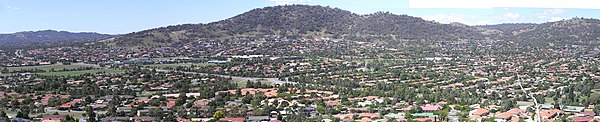
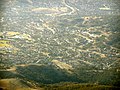
Tuggeranong is a district in the Australian Capital Territory in Australia. The district is subdivided into divisions (suburbs), sections and blocks and is the southernmost district of the Australian Capital Territory. The district comprises nineteen suburbs and occupies 117 square kilometres (45 sq mi) to the east of the Murrumbidgee River.
Calwell is a medium-sized suburb of Canberra, Australia in the district of Tuggeranong. Tuggeranong Hill is on its southern border and the Tuggeranong Homestead is to the north. Calwell is located close to the Monaro Highway which provides a direct route to Canberra City and to Cooma.
Gowrie is a suburb of Canberra, Australia, located in the northern end of the Tuggeranong Valley. Tuggeranong suburbs are the southernmost of Australia's capital city. Gowrie is named after Brigadier-General Alexander Gore Arkwright Hore-Ruthven, 1st Earl of Gowrie (1872–1955), Governor-General of Australia from 1936 to 1944.

Hume is a suburb of Canberra, and is adjacent to the District of Jerrabomberra in New South Wales.The suburb is named after the explorer Hamilton Hume and streets are named after Australian industrialists and businessmen. Hume is a light-industrial suburb and there is no significant housing development. At the 2021 census, Hume had a population of 395, up from six in 2006, as a result of the construction of the Alexander Maconochie Centre. The location of the prison has also given Hume a highly unusual gender ratio with 92.7% of the permanent population being male.

Farrer is a suburb in the Canberra, Australia district of Woden. The postcode is 2607.

Banks is a suburb in the Canberra, Australia district of Tuggeranong. It is the most southerly suburb of Canberra. The suburb is named after Sir Joseph Banks (1743–1820), the botanist who accompanied Captain James Cook to Botany Bay in 1770. The suburb was gazetted on 12 March 1987. The theme of the street names is botany or natural history.

Bonython is a suburb of Tuggeranong, a township in southern Canberra, capital city of Australia.

Chisholm is a suburb in the Canberra, Australia district of Tuggeranong, named after Caroline Chisholm.
Fadden is a suburb in the Canberra, Australia district of Tuggeranong. The postcode is 2904. The suburb is named after Sir Arthur Fadden, Prime Minister of Australia briefly in 1941. It was gazetted on 5 August 1975. Its streets are named after Queensland politicians. It is surrounded by Macarthur, Gowrie and Wanniassa. It is bounded by Erindale Drive, the Wanniassa Hills Nature Reserve, Fadden Pine Plantation and Sternberg Crescent.
Gilmore is a suburb in the Canberra, Australia district of Tuggeranong. The postcode is 2905. The suburb is named after the poet and journalist, Dame Mary Gilmore. It was gazetted on 5 August 1975. Streets are named after journalists, particularly female journalists.

Gordon is a suburb in the Canberra, Australia district of Tuggeranong. The postcode is 2906. The suburb is named after the poet Adam Lindsay Gordon (1833–1870). It was gazetted on 12 March 1987. Streets are named after sportspersons, an example is Woodfull Loop, named after the captain of the Australia national cricket team during the Bodyline test series.

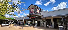
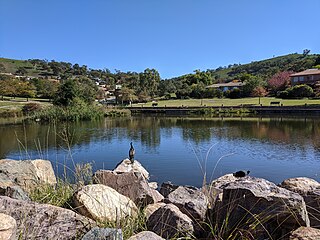
Greenway is a suburb in the Canberra, Australia district of Tuggeranong. The postcode is 2900. The suburb is named after the architect, Francis Greenway (1777–1837). It was gazetted on 17 October 1986. The streets are named after architects. It includes the Tuggeranong Town Centre, Lake Tuggeranong and small residential areas on the northwestern and northeastern shores of the lake.

Isabella Plains is a suburb in the Canberra, Australia district of Tuggeranong. The postcode is 2905. The suburb is indirectly named after Isabella Maria Brisbane (1821–1849), who was the daughter of Sir Thomas Brisbane, the colonial Governor of New South Wales when the area was first explored by white settlers in 1823. Joseph Wild was employed by Brigade Major John Ovens and Captain Mark Currie to guide them to the Murrumbidgee River. They travelled south along the river and named the area now known as Tuggeranong "Isabella's Plain". This name was adopted, with a slight change of spelling, for the name of the new suburb. It was gazetted on 5 August 1975. Streets are named after New South Wales parish names.
Kambah is the northernmost suburb in the district of Tuggeranong, Canberra. It is located just south of Mount Taylor in the Canberra Nature Park. It is located north of the suburbs of Greenway and Wanniassa. It is bounded by Sulwood Drive to the north and Athllon Drive to the south-east.
Macarthur is a suburb in the Canberra district of Tuggeranong. The suburb is named after John Macarthur, one of the founders of Australia's Merino wool industry. It was gazetted on 22 March 1982 and first settled in 1983. The wool industry is the theme for street names. The suburb has an area of 1.27 km2. It is next to the suburbs of Fadden and Gilmore, and is located north of Isabella Drive.

Monash is a suburb in the district of Tuggeranong, Canberra, Australia. The suburb is named after General Sir John Monash,, who commanded the Australian Army in France in the First World War. It was gazetted on 1 August 1975 and first settled in 1978. The suburb has an area of 3.41 km2. Streets are named after engineers and the suburb consists primarily of detached houses on suburban blocks.
Oxley is the smallest suburb in Canberra. It is located in the district of Tuggeranong. The suburb is named after the explorer John Joseph William Molesworth Oxley, who explored parts of New South Wales. It was gazetted on 22 March 1982 and first settled in 1985. Streets are named after social reformers and the suburb has an area of 1.08 km2.
Richardson is a suburb in the Canberra, Australia, district of Tuggeranong. The postcode is 2905. It was gazetted on 5 May 1975. Streets are named after writers, especially female writers. It is next to the suburbs of Calwell, Isabella Plains, Gowrie and Chisholm. It is bounded by Johnson Drive, Ashley Drive and Isabella Drive. This suburb is named after the novelist Ethel Florence Lindesay Richardson (1870–1946) who wrote under the pen name Henry Handel Richardson.

Theodore is a suburb in the Canberra, Australia district of Tuggeranong. The postcode is 2905. The suburb is named after Edward Granville Theodore (1884–1950), a Queensland premier and deputy Prime Minister. It was gazetted on 5 August 1975. Streets are named after people involved with the civilian war effort during the world wars. The main street through the suburb is named after Sir Lawrence Wackett KBE, DFC, AFC, who is widely regarded as the "father of the Australian aircraft industry".

Wanniassa is a suburb in Australia's capital, Canberra: more specifically, in the city's southern district of Tuggeranong. The suburb takes its name from a pastoral property granted to Thomas McQuoid in 1835, which he named after Wanayasa in West Java, Indonesia, where McQuoid had previously owned property. Streets are named after Victorian state politicians and the suburb was gazetted on 21 May 1974.