
Weston is a suburb of Canberra, Australian Capital Territory, Australia. At the 2021 census, Weston had a population of 4,000 people.
Cook is a suburb of the Belconnen district of Canberra, located within the Australian Capital Territory, Australia. At the 2016 census, Cook had a population of 2,965 people.

Macquarie is a residential suburb in the Belconnen district of Canberra, located within the Australian Capital Territory, Australia. Macquarie was gazetted as a division on 22 June 1967 in recognition of Major-General Lachlan Macquarie, a former Governor of New South Wales. Streets in Macquarie are named after contemporaries of Governor Macquarie.
O'Malley is an affluent suburb of Canberra, Australian Capital Territory. At the 2021 census, O'Malley had a population of 928 people. There are numerous embassies in O'Malley. The suburb is named after King O'Malley, who was the politician who arranged the competition for a design for Canberra. Streets in O'Malley are named with Aboriginal words.

Fisher is a suburb of Canberra, Australian Capital Territory, Australia located in the district of Weston Creek. Fisher was named after Andrew Fisher (1862–1928), coal miner, founding member of the federal parliamentary Labor Party and Prime Minister of Australia for three terms between 1908 and 1915. The theme for the street names in Fisher is Australian mines and mining towns.

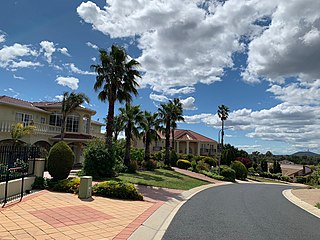
Stirling is a suburb of Canberra, Australian Capital Territory, Australia. It is located in the Weston Creek district.

Page is a residential suburb in the Belconnen district of Canberra, located within the Australian Capital Territory, Australia. The suburb is named in honour of Sir Earle Page, a Prime Minister. Streets in Page are named in honour of Australian scientists. Page was established in 1968.

Garran is a suburb in the Woden district of Canberra in the Australian Capital Territory. Garran was named after Sir Robert Garran who made numerous contributions to the development of higher education in Canberra. The streets in Garran are named after Australian writers. The suburb was first settled in 1966 and has an area of 2.74 km2.

Belconnen is the most inner suburb of the larger district of Belconnen in Canberra, Australia. Sharing its name with the larger district which encapsulates it, the suburb is surrounded with well developed infrastructure, and planning which allows it sunset views from the Brindabellas on its western side. The suburb contains important amenities for the District of Belconnen including the Belconnen Town Centre and Lake Ginninderra as well as its own well populated residential areas. It is bounded by Ginninderra Drive, Aikman Drive, Eastern Valley Way, Belconnen Way and Coulter Drive. It has a number of parks such as Margaret Timpson Park, Eastern Valley Oval and on the foreshores of Lake Ginninberra, Diddams Close Park and John Knight Memorial Park.
Higgins is a suburb in the Belconnen district of Canberra, in the Australian Capital Territory, Australia. The suburb is named after politician and judge Henry Bournes Higgins (1851–1929). It was gazetted on 6 June 1968. The streets of Higgins are named after judges.
Holt is a suburb in the Belconnen district of Canberra, located within the Australian Capital Territory, Australia. It was gazetted on 2 July 1970 and was named after Harold Holt, Prime Minister of Australia 1966–67. Streets are named after sportsmen and sportswomen.

Scullin is a residential suburb in the Belconnen district of Canberra, located within the Australian Capital Territory, Australia. The suburb is named after Prime Minister of Australia James Scullin. It was gazetted on 6 June 1968. In the city of Canberra, suburbs are assigned street names that reflect a distinct sub-group of cultural or historical Australian significance. The streets in the suburb of Scullin are named after aviators. Scullin is located adjacent to the suburbs of Higgins, Florey, Page and Hawker. Southern Cross Early Childhood School and Scullin neighbourhood oval are located within the suburb. It is bordered by Kingsford Smith Drive, Belconnen Way, Southern Cross Drive and Chewings Street. Scullin is approximately 20 minutes walk and 5 minutes by car from the Belconnen Town Centre and 15 minutes walk and 3 minutes by car from the Hawker Shopping Centre. It is approximately 10 to 15 minutes by car from Canberra City and 30 minutes from Canberra Airport.

Hughes is a suburb in the Canberra, Australia district of Woden. The postcode is 2605. The area of the suburb is 1.81 km2.

Isaacs is a suburb in the district of Woden in Canberra, Australian Capital Territory. The postcode is 2607.

Pearce is a suburb in the Canberra, Australia district of Woden. The postcode is 2607. It was named after the longest-serving Senator and longest-serving Minister in Australia's federal history, Sir George Pearce.

Phillip is a suburb of Canberra, Australia in the district of Woden Valley. It is located in the centre of the district and contains the district's main commercial centre, Woden Town Centre. Phillip had a residential population of 5,197 at the 2021 census. 67.0% of the population lived in flats. Many more flats are being planned or built.

Torrens is a suburb in the Woden Valley district of Canberra, Australia. It is named after Sir Robert Torrens, a former Premier of South Australia and instigator of the Torrens title system of land registration. The suburb was gazetted on 12 May 1966.
Oxley is the smallest suburb in Canberra. It is located in the district of Tuggeranong. The suburb is named after the explorer John Joseph William Molesworth Oxley, who explored parts of New South Wales. It was gazetted on 22 March 1982 and first settled in 1985. Streets are named after social reformers and the suburb has an area of 1.08 km2.

Theodore is a suburb in the Canberra, Australia district of Tuggeranong. The postcode is 2905. The suburb is named after Edward Granville Theodore (1884–1950), a Queensland premier and deputy Prime Minister. It was gazetted on 5 August 1975. Streets are named after people involved with the civilian war effort during the world wars. The main street through the suburb is named after Sir Lawrence Wackett KBE, DFC, AFC, who is widely regarded as the "father of the Australian aircraft industry".
Tralee is a planned suburb of Queanbeyan, New South Wales. It lies south of Jerrabomberra and the site once planned for the future city of Environa. It was named after Tralee in Ireland.

