
Gloucestershire is a ceremonial county in South West England. It is bordered by Herefordshire to the north-west, Worcestershire to the north, Warwickshire to the north-east, Oxfordshire to the east, Wiltshire to the south, Bristol and Somerset to the south-west, and the Welsh county of Monmouthshire to the west. The city of Gloucester is the largest settlement and the county town.
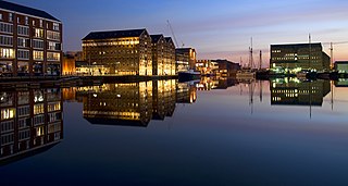
Gloucester is a cathedral city and the county town of Gloucestershire in the South West of England. Gloucester lies on the River Severn, between the Cotswolds to the east and the Forest of Dean to the west; it is sited 19 miles (31 km) east of Monmouth and 17 miles (27 km) east of the border with Wales. Gloucester has a population of around 132,000, including suburban areas. It is a port, linked via the Gloucester and Sharpness Canal to the Severn Estuary.

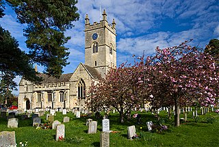
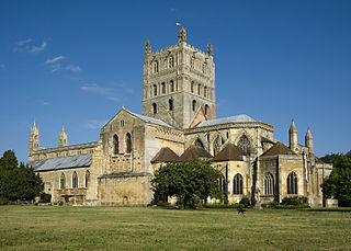
Tewkesbury is a market town and civil parish in the north of Gloucestershire, England. The town grew following the construction of Tewkesbury Abbey in the twelfth century and played a significant role in the Wars of the Roses. It stands at the confluence of the River Severn and the River Avon, and thus became an important trading point, which continued as railways and, later, the M5 and M50 motorway connections were established. The town gives its name to the Borough of Tewkesbury, a local government district of Gloucestershire. The town lies on the border with Worcestershire, marked largely by the Carrant Brook.

The University of Gloucestershire is a public university based in Gloucestershire, England. It is located over three campuses, two in Cheltenham and one in Gloucester. In March 2021, the university purchased the former Debenhams store in Gloucester City Centre, with a new campus due to open there in 2023.
Bishop's Cleeve is a village and civil parish in the Borough of Tewkesbury in the ceremonial county of Gloucestershire, England. The village lies at the foot of Cleeve Hill, the highest point in the Cotswolds. Bishop's Cleeve had a population of 10,612 in 2011, which has increased to 14,068 in the 2021 Census. The village is 13 miles (21 km) from Gloucester and 44 miles (71 km) from Oxford. The village is also close to the towns of Cheltenham, Tewkesbury and Evesham.

Churchdown is a large village in Gloucestershire, England, situated between Gloucester and Cheltenham in the south of the Tewkesbury Borough.

Brockworth is a village and parish in the Borough of Tewkesbury, Gloucestershire, England, situated on the old Roman road that connects the City of Gloucester with Barnwood. It is located 4 miles (6.4 km) southeast of central Gloucester, 6 miles (9.7 km) southwest of Cheltenham and 11.5 miles (18.5 km) north of Stroud. The population taken at the 2011 census was 7,387. The population increased to 9,422 at the 2021 Census.

Hucclecote is a suburb in Gloucestershire, United Kingdom, comprising a ward in the City of Gloucester. It is located on the periphery of the city, between Barnwood and Brockworth, along Ermin Way, an old Roman road connecting Gloucester with Cirencester and the Cotswolds.

Abbeydale and Abbeymead are modern suburbs of the city of Gloucester in the county of Gloucestershire, England. They lie approximately 3 miles south-east of the city centre, and are bounded by the suburbs of Coney Hill to the north west, Barnwood and Hucclecote to the north and north east, Matson to the south west and the M5 motorway to the south and east. Mostly connected with Segregated Bicycle Paths into Gloucester city along Metz Way. The village of Upton St Leonards is directly across the M5 motorway.
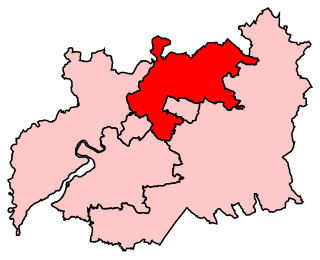
Tewkesbury is a constituency in Gloucestershire represented in the House of Commons of the UK Parliament since its 1997 recreation by Laurence Robertson, a Conservative.
The Gloucestershire Fire and Rescue Service is the statutory emergency fire and rescue service for the non-metropolitan county of Gloucestershire, England. The service is run by Gloucestershire County Council. The service does not cover the unitary authority of South Gloucestershire which is covered by Avon Fire and Rescue Service.
Gloucestershire County Council is the upper-tier local authority for the non-metropolitan county of Gloucestershire, in England. The council was created in 1889. The council's principal functions are county roads and rights of way, social services, education and libraries, but it also provides many other local government services in the area it covers. The non-metropolitan county is smaller than the ceremonial county, the latter additionally including South Gloucestershire. The council went under no overall control following a change of allegiance in May 2024, having previously been under Conservative majority control. It is based at Shire Hall in Gloucester.

The Gloucestershire Rugby Football Union is the union responsible for rugby union in the county of Gloucestershire, England and is one of the constituent bodies of the national Rugby Football Union. Formed in 1878, it has won the county championship on numerous occasions.
Gloucester 1 is an English rugby union league which sits at the ninth level of league rugby union in England for teams based primarily in the county of Gloucestershire but also on occasion teams from Bristol. Promoted clubs move into Gloucester Premier and relegated clubs drop into either Gloucester 2 North or Gloucester 2 South depending on location. Each year clubs in this division also take part in the RFU Junior Vase - a level 9-12 national competition.
Gloucester 2 North and Gloucester 2 South are English rugby union leagues which sits at the tenth level of league rugby union in England for teams primarily based in Gloucestershire as well as some teams from Bristol. Promoted clubs move into Gloucester 1 and since the discontinuation of Gloucester 3 at the end of the 2017–18 season there is currently no relegation. Up until 2017-18 Gloucester 2 was a single division but has since been split into two regional divisions.
The Borough of Tewkesbury is a local government district with borough status in Gloucestershire, England. The borough is named after its largest town, Tewkesbury, which is where the council is based. The district also includes the town of Winchcombe and numerous villages including Bishops Cleeve, Ashchurch, Churchdown, Innsworth and Brockworth as well as other hamlets and surrounding rural areas. Parts of the district lie within the Cotswolds Area of Outstanding Natural Beauty.

North Cotswolds is a newly created constituency of the House of Commons in the UK Parliament. Further to the completion of the 2023 Periodic Review of Westminster constituencies, it will first be contested at the next general election.

