Related Research Articles

The City of Moreland is a local government area in metropolitan Melbourne, Australia. It comprises the inner northern suburbs between 4 and 11 kilometres from the Melbourne CBD.

Bishopston is a suburb of the city of Bristol in south west England. Bishopston is around Gloucester Road (A38), the main northern arterial road in the city and Bishop Road.

Brockworth is a parish, village and district of Gloucester in Gloucestershire, England, situated on the old Roman road that connects the City of Gloucester with Barnwood. It is located 4 miles (6.5 km) southeast of central Gloucester, 6 miles (9.5 km) southwest of Cheltenham and 11.5 miles (18.5 km) north of Stroud. The population taken at the 2011 census was 7,387.

Penyrheol is a residential area of the town of Caerphilly, Wales. It is part of the community of Penyrheol, Trecenydd and Energlyn in the County Borough of Caerphilly. It is often spelt as Pen-yr-heol by the local community. At the 2011 census the population of the community was 12,537.

Kemble is a village and civil parish in the Cotswold District of Gloucestershire, England. Historically part of Wiltshire, it lies 4 miles (6.4 km) from Cirencester and is the settlement closest to Thames Head, the source of the River Thames. At the 2011 census it had a population of 1,036.

Carleton is a federal electoral district in Ontario, Canada, represented in the House of Commons of Canada from 1867 to 1968 and since 2015. It was represented in the Legislative Assembly of Upper Canada from 1821 to 1840 and in the Legislative Assembly of the Province of Canada from 1841 until 1866.

Gloucester is a constituency centred on the cathedral city and county town of the same name, represented in the House of Commons of the UK Parliament by Richard Graham of the Conservative Party.

Stone is a small village in the parish of Ham and Stone, Gloucestershire, England. It stands on the A38 road, just south-west of its crossing of the Little Avon River, roughly halfway between Bristol and Gloucester at grid reference ST684953. It is adjacent to the county boundary with South Gloucestershire. The part of the community just north-east of the river is called Woodford. In 2019 it had an estimated population of 527.

Innsworth is a suburb of Gloucester, it is a civil parish and forms part of the borough of Tewkesbury. The parish population taken at the 2011 census was 2,468.

Baunton is a village and civil parish in the Cotswold district of Gloucestershire, England, located about two miles north of Cirencester on the River Churn.
Benhall is a small district within the town of Cheltenham, Gloucestershire. It lies south-west of the town centre, just south of the A40, the main road to Gloucester, and north of the district of Up Hatherley. It falls mainly within the Anglican parish of St Mark.

Llandaff North, is a district, community and coterminous electoral ward in the north of Cardiff, the capital city of Wales.
Beechwood is an electoral district (ward) and coterminous community (parish) of the city of Newport.

St Ishmael is a community in Carmarthenshire, Wales. The community population taken at the 2011 census was 1,370. It comprises the village of Ferryside and the surrounding rural areas. The community is bordered by the communities of: Llandyfaelog; Kidwelly; Pembrey and Burry Port Town; and Llansteffan, all being in Carmarthenshire. It is named for the 6th-century Breton prince and Welsh saint Isfael.

Ambleston is a village, parish, and community in Pembrokeshire, Wales, lying seven miles (11 km) north-north-east of Haverfordwest. The parish includes the hamlets of Wallis and Woodstock.

Barton and Tredworth is an area of Gloucester, England that lies just outside the Eastgate of the city and has a population of 10,953 at the 2011 Census. Up to 45 different communities live in the area and as many as 50 languages are spoken here.

S. J. Moreland and Sons was a family company, founded in 1867 and wound up in 1976. It manufactured "England's Glory" matches.

Tawe-Uchaf is a community in Powys, Wales. Situated north-east of Ystradgynlais in the upper valley of the River Tawe, it includes the villages of Caehopkin, Coelbren, Glyntawe, Pen-y-cae, Penwyllt and Ynyswen. It had a population in 2001 of 1,516, increasing at the 2011 Census to 1,562.

The Westgate area of Gloucester is centred on Westgate Street, one of the four main streets of Gloucester and one of the oldest parts of the city. The population of the Westgate ward in Gloucester was 6,687 at the time of the 2011 Census.
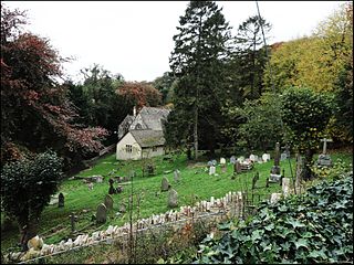
Randwick, Gloucestershire is a village bordering the market town of Stroud in Gloucestershire, England, the United Kingdom. It is known locally for its folk traditions such as the Randwick Wap, a celebration of May Day, and its annual pantomime.
References
- ↑ "Gloucester Ward population 2011" . Retrieved 27 October 2015.
Coordinates: 51°51′N2°15′W / 51.850°N 2.250°W
| | This Gloucestershire location article is a stub. You can help Wikipedia by expanding it. |