Related Research Articles

Nyssa is a city in Malheur County, Oregon, United States. The population was 3,267 at the 2010 census. The city is located along the Snake River on the Idaho border, in the region of far eastern Oregon known as the "Treasure Valley". It is part of the Ontario, OR–ID Micropolitan Statistical Area.
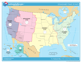
In the United States, time is divided into nine standard time zones covering the states, territories and other US possessions, with most of the country observing daylight saving time (DST) for approximately the spring, summer, and fall months. The time zone boundaries and DST observance are regulated by the Department of Transportation, but no single map of those existed until the agency announced intentions to make one in September 2022. Official and highly precise timekeeping services (clocks) are provided by two federal agencies: the National Institute of Standards and Technology (NIST) ; and the United States Naval Observatory (USNO). The clocks run by these services are kept synchronized with each other as well as with those of other international timekeeping organizations.

The Boise, Idaho Metropolitan Statistical Area (MSA) is an area that encompasses Ada, Boise, Canyon, Gem, and Owyhee counties in southwestern Idaho, anchored by the cities of Boise and Nampa. It is the main component of the wider Boise–Mountain Home–Ontario, ID–OR Combined Statistical Area, which adds Elmore and Payette counties in Idaho and Malheur County, Oregon. It is the state's largest officially designated metropolitan area and includes Idaho's three largest cities: Boise, Nampa, and Meridian. Nearly 40 percent of Idaho's total population lives in the area.
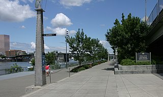
The Eastbank Esplanade is a pedestrian and bicycle path along the east shore of the Willamette River in Portland, Oregon, United States. Running through the Kerns, Buckman, and Hosford-Abernethy neighborhoods, it was conceived as an urban renewal project to rebuild the Interstate 5 bicycle bypass washed out by the Willamette Valley Flood of 1996. It was renamed for former Portland mayor Vera Katz in November 2004 and features a statue of her near the Hawthorne Bridge.

Shepperd's Dell is a small canyon in the Columbia River Gorge in Oregon, located at 45.54833°N 122.195°W which is less than one-third mile southeast of Rooster Rock State Park. The Shepperd's Dell Bridge is listed on the National Register of Historic Places.

Oregon's 1st congressional district is a congressional district located in the U.S state of Oregon. The district stretches from Portland's western suburbs and exurbs, to parts of the Oregon coast. The district includes the principal cities of Beaverton, Hillsboro, and Tigard, all located in the Portland metropolitan area. Geographically, the district is located in the northwest corner of Oregon. It includes all of Clatsop, Columbia and Tillamook Counties, most of Washington County excluding the extreme southeast, and a portion of southwest Multnomah County in Portland.

Oregon's 3rd congressional district covers most of Multnomah County, including Gresham, Troutdale, and most of Portland east of the Willamette River. It also includes the northeastern part of Clackamas County and all of Hood River County. Generally, most of Portland east of the Willamette River is in the 3rd District.
Chinese Massacre Cove is an area along the Snake River in Wallowa County, Oregon, United States. It is located in the Wallowa–Whitman National Forest and the Hells Canyon National Recreation Area, upriver from the Snake's confluence with the Imnaha River. In May 1887, it was the location of the Hells Canyon Massacre, where up to thirty-four Chinese gold miners were ambushed, murdered, and robbed.
Bull Run National Forest was established as the Bull Run Forest Reserve by the United States General Land Office in Oregon on June 17, 1892, with 142,080 acres (575.0 km2). After the transfer of federal forests to the U.S. Forest Service in 1905, it became a National Forest on March 4, 1907. On July 1, 1908, the entire forest was combined with part of Cascade National Forest to establish Oregon National Forest and the name was discontinued. The lands are now part of Mount Hood National Forest.
Imnaha National Forest was established in Oregon on March 1, 1907 with 1,750,240 acres (7,083.0 km2) when the first Wallowa National Forest and Chenismus National Forest were combined. Its lands presently exist as part of Wallowa–Whitman National Forest.
Nicholson is an unincorporated community in Kenton County, Kentucky, United States, located directly south of Independence.
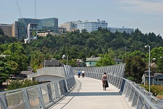
Marquam Hill is a populated hill located just south of Downtown Portland, Oregon, United States in the Homestead neighborhood. It is also called Pill Hill because it is home to Oregon Health & Science University, Portland VA Medical Center and Shriners Children's Portland.
Wyeth is an unincorporated locale in Hood River County, Oregon, United States. It is the site of a campground area in the Columbia River Gorge National Scenic Area off Interstate 84 (I-84).
Hayward is an unincorporated community in Washington County, Oregon, United States. It is located off U.S. 26 near Manning. It has a cemetery and once had a post office, and before 1891, the neighboring town of Greenville, Oregon had the only nearby post office.

Kapawe'no 150B, historically known as Freeman 150B, is an Indian reserve of the Kapawe'no First Nation in Alberta, located within Big Lakes County. It is 8 kilometers northwest of Lesser Slave Lake. In the 2016 Canadian Census, it recorded a population of 154 living in of its 45 total private dwellings.
Willow Creek Wildlife Area, located in northeastern Oregon, United States, near the Columbia River, is operated by the Oregon Department of Fish and Wildlife. Birds watchers may find birds of prey, waterfowl, wading birds, songbirds and shorebirds.
KXCM 96.3 FM is a radio station licensed to Joshua Tree, California. The station broadcasts a country music format and is owned by Copper Mountain Broadcasting Company.
The Hells Canyon Motorcycle Rally is an annual motorcycle rally at Hells Canyon that meets in Baker City in the state of Oregon, United States. It was started c. 2000 by Steve Folkestad and a brother.
References
- ↑ "Copper, Oregon". Geographic Names Information System . United States Geological Survey, United States Department of the Interior . Retrieved August 4, 2016.
45°45′05″N116°32′54″W / 45.7513°N 116.5482°W
Municipalities and communities of Wallowa County, Oregon, United States | ||
|---|---|---|
| Cities |  | |
| CDP | ||
| Other communities | ||
| Ghost towns | ||
| | This Wallowa County, Oregon state location article is a stub. You can help Wikipedia by expanding it. |