Related Research Articles
The North Fork Musselshell River is a tributary of the Musselshell River, approximately 35 miles (56 km) long, in Montana in the United States.
The South Fork Musselshell River is a tributary of the Musselshell River in south central Montana in the United States.

Fort Koshkonong was a military fort located near the present-day city of Fort Atkinson, Wisconsin. Intended to control the confluence of the Bark and Rock rivers, it was used as a station for local militia units and the U.S. regulars in the region to scout the British Band, a group of Native Americans who fought against government units during the 1832 Black Hawk War. General Henry Atkinson was the commander of the fort during the war. Black Hawk was in the same general area, but evaded capture and started to flee towards the Wisconsin River. The original fort was abandoned by the Army following the conflict. Local settlers dismantled it for the wood as the town developed.
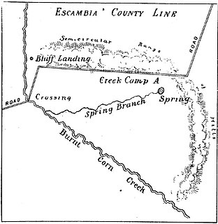
The Battle of Burnt Corn, also known as the Battle of Burnt Corn Creek, was an encounter between United States armed forces and Creek Indians that took place July 27, 1813 in present-day southern Alabama. The battle was part of the Creek War.

The Hopi Reservation is a Native American reservation for the Hopi and Arizona Tewa people, surrounded entirely by the Navajo Nation, in Navajo and Coconino counties of Arizona, United States. The site in north-eastern Arizona has a land area of 2,531.773 sq mi (6,557.262 km²) and as of the 2000 census had a population of 6,946. The Hopi Reservation, like most of Arizona but unlike the surrounding Navajo Nation, does not observe daylight saving time. Until 1974, the two nations shared the Navajo–Hopi Joint Use Area, until the Navajo–Hopi land settlement act created an artificial boundary through the area. The partition of this area, commonly known as Big Mountain, by Acts of Congress in 1974 and 1996, has resulted in continuing controversy. The system of villages unites three mesas in the pueblo style traditionally used by the Hopi. Walpi is the oldest village on First Mesa, having been established in 1690 after the villages at the foot of mesa Koechaptevela were abandoned for fear of Spanish reprisal after the 1680 Pueblo Revolt. The Tewa people live on First Mesa. Hopi also occupy the Second Mesa and Third Mesa. The community of Winslow West is off-reservation trust land of the Hopi tribe. The Hopi Tribal Council is the local governing body consisting of elected officials from the various reservation villages. Its powers were given to it under the Hopi Tribal Constitution. The Hopi consider their life on the reservation an integral and critically sustaining part of the "fourth world". Hopi High School is the secondary education institute for reservation residents. Hopi Radio, a station with a mix of traditional Hopi and typical American programming is run for the reservation and provides internships for Hopi High School.
The Mogollon Plateau or Mogollon Mesa is a pine-covered southern plateau section of the larger Colorado Plateau in east-central Arizona and west-central New Mexico, United States. The southern boundary of the plateau is the Mogollon Rim. The Mogollon Plateau is 7,000–8,000 feet (2,100–2,400 m) high. The plateau lends its name to the Mogollon tribe, part of the Cochise-Mogollan peoples who inhabited this and nearby areas from 5,000 to 2,500 years ago. Their descendants are believed to include the Anasazi.

Tuscarora Creek in Berkeley County, West Virginia, is an 11.4-mile-long (18.3 km) tributary of Opequon Creek, which drains into the Potomac River in the Chesapeake Bay watershed.

Mountain Park is a ghost town in western Alberta, south of Cadomin, elevation 6200 feet, at the end of the historic Alberta Coal Branch line of the Canadian National Railway.
Nameless is a populated place in Travis County, Texas.
Kinlichee Creek is a stream in the U.S. state of Arizona. It is located northeast of the census-designated place of Ganado in Apache County.
Jesse Creek is a stream in Audrain and Callaway counties in the U.S. state of Missouri. It is a tributary of Beaverdam Creek.
San Felipe Creek is a stream in Imperial and San Diego Counties of California. It arises in the Volcan Mountains of San Diego County 33°11′57″N116°37′35″W, and runs eastward, gathering the waters of most of the eastern slope of the mountains and desert of the county before it empties into the Salton Sea. It is probably the last remaining perennial natural desert stream in the Colorado Desert region. In 1974, the San Felipe Creek Area was designated as a National Natural Landmark by the National Park Service.

Ciénega Creek is an intermittent stream located in the Basin and Range region of southern Arizona, and is one of the most intact riparian corridors left in the state. It originates in the Canelo Hills and continues northwest about 50 miles (80 km) to an area just outside Tucson, where it becomes known as Pantano Wash. Pantano Wash continues through Tucson and eventually connects with the Rillito River.

Laguña Creek also formerly also known as Tyende Creek, is a stream in the Navajo and Apache Counties of Arizona. Laguña Creek has its source at 36°41′15″N110°30′36″W, at the confluence of Long Canyon and Dowozhiebito Canyon at an elevation of 6325 feet / 1928 meters at the head of Tsegi Canyon. Its mouth is in the Chinle Valley at its confluence with Chinle Wash which together forms Chinle Creek, at an elevation of 4774 feet / 1455 meters. Chinle Creek is a tributary of San Juan River which is in turn a tributary of the Colorado River.

Chinle Creek is a tributary stream of the San Juan River in Apache County, Arizona and San Juan County, Utah. Its source is at 36°53′40″N109°44′37″W, the confluence of Laguña Creek and the Chinle Wash arroyo. Its name is derived from the Navajo word ch'inili meaning 'where the waters came out'. Its sources is in Canyon de Chelly National Monument where Canyon de Chelly and Canyon del Muerto have their confluence at an elevation of 5,616 feet at 36°08′35″N109°29′17″W. It then trends northwest to its confluence with Laguña Creek where it forms Chinle Creek, 7 miles northeast of Dennehotso, Arizona at an elevation of 4,774 feet / 1,455 meters.
White Oak Valley is an unincorporated community in Brown County, in the U.S. state of Ohio.
Lost Dog Creek is a stream in the U.S. state of South Dakota.
Chanos is a municipality located in the province of Zamora, Castile and León, Spain. According to the 2015 census (INE), the municipality has a population of 55 inhabitants.
References
Coordinates: 35°16′21″N110°55′37″W / 35.27250°N 110.92694°W