Sedona is a city that straddles the county line between Coconino and Yavapai counties in the northern Verde Valley region of the U.S. state of Arizona. As of the 2010 census, its population was 10,031. It is within the Coconino National Forest.

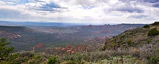
The Mogollon Rim is a topographical and geological feature cutting across the northern half of the U.S. state of Arizona. It extends approximately 200 miles (320 km), starting in northern Yavapai County and running eastward, ending near the border with New Mexico. It forms the southern edge of the Colorado Plateau in Arizona.
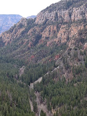
State Route 89A is an 83.85-mile (134.94 km) state highway that runs from Prescott north to Flagstaff in the U.S. state of Arizona. The highway begins at SR 89 in Yavapai County and heads northward from Prescott, entering Jerome. From Jerome, the route then heads to Cottonwood and Sedona. The highway is notable for its scenic value as it passes through Sedona and the Oak Creek Canyon. The route then enters Coconino County soon after leaving Sedona. The highway proceeds to Flagstaff, where it crosses Interstate 17 (I-17) and I-40. The highway ends at I-40 Business in Flagstaff. What is now SR 89A became a state highway in the late 1920s as SR 79. The highway was extended and improved several times through 1938. SR 79 was renumbered to U.S. Route 89A in 1941 and then to SR 89A in the early 1990s.

Northern Arizona is an unofficial, colloquially-defined region of the U.S. state of Arizona. Generally consisting of Apache, Coconino, Mohave, Navajo, and Gila counties, the region is geographically dominated by the Colorado Plateau, the southern border of which in Arizona is called the Mogollon Rim.
North Central Arizona is a geographical region of Arizona. It is in the Transition Zone between the Basin and Range Province and the Colorado Plateau, and has some of the most rugged and scenic landscapes in Arizona.

The Coconino National Forest is a 1.856-million acre United States National Forest located in northern Arizona in the vicinity of Flagstaff. Originally established in 1898 as the "San Francisco Mountains National Forest Reserve", the area was designated a U.S. National Forest in 1908 when the San Francisco Mountains National Forest Reserve was merged with lands from other surrounding forest reserves to create the Coconino National Forest. Today, the Coconino National Forest contains diverse landscapes, including deserts, ponderosa pine forests, flatlands, mesas, alpine tundra, and ancient volcanic peaks. The forest surrounds the towns of Sedona and Flagstaff and borders four other national forests; the Kaibab National Forest to the west and northwest, the Prescott National Forest to the southwest, the Tonto National Forest to the south, and the Apache-Sitgreaves National Forest to the southeast. The forest contains all or parts of ten designated wilderness areas, including the Kachina Peaks Wilderness, which includes the summit of the San Francisco Peaks. The headquarters are in Flagstaff. There are local ranger district offices in Flagstaff, Happy Jack, and Sedona.

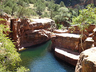
Slide Rock State Park is an Arizona State Park located in Oak Creek Canyon 7 miles (11 km) north of Sedona, Arizona, United States. It takes its name from a natural water slide formed by the slippery bed of Oak Creek. Slide Rock State Park is located on Coconino National Forest land and is co-managed by the Arizona State Parks agency and the United States Forest Service. Tall red rock formations that are typical of the region also surround the park, which contains a 43-acre (17 ha) working apple farm.

Sycamore Canyon is the second largest canyon in the Arizona redrock country, after Oak Creek Canyon. The 21-mile (34 km) long scenic canyon reaches a maximum width of about 7 miles (11 km). It is in North Central Arizona bordering and below the Mogollon Rim, and is located west and northwest of Sedona in Yavapai and Coconino counties.
Sycamore Canyon Wilderness is a 56,000-acre wilderness area in the Coconino, Kaibab and Prescott national forests in the U.S. state of Arizona. Encompassing Sycamore Canyon and its surrounds from south of Williams to the confluence of Sycamore Creek with the Verde River, the wilderness is about 40 miles (64 km) southwest of Flagstaff. The canyon is one of several in Arizona that cut through the Mogollon Rim. Relevant United States Geological Survey (USGS) map quadrangles are Davenport Hill, White Horse Lake, May Tank Pocket, Perkinsville, Sycamore Basin, and Clarkdale. Red Rock-Secret Mountain Wilderness borders Sycamore Canyon Wilderness on the east.
Wet Beaver Wilderness is a 6,155-acre wilderness area located in the Coconino National Forest in the U.S. state of Arizona.

The Red Rock-Secret Mountain Wilderness is a 47,195-acre wilderness area located within the Coconino National Forest in the U.S. state of Arizona.

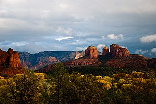
Bell Rock is a butte just north of the Village of Oak Creek, Arizona, south of Sedona in Yavapai County. With an elevation at its summit of 4,919 feet (1,499 m), it is just west of Courthouse Butte. Its panoramic views make it a popular landmark and tourist attraction.
Courthouse Butte is a butte just north of the Village of Oak Creek, Arizona, south of Sedona in Yavapai County. Summit elevation is 5,454 feet (1,662 m). It is just east of Bell Rock.
Red Rock State Park is a state park of Arizona, United States, featuring a red sandstone canyon outside the city of Sedona. The main mission of this day-use park is the preservation of the riparian habitat along Oak Creek. Red Rock State Park serves as an environmental education facility for the public and for school or private groups, and provides limited passive recreational opportunities.
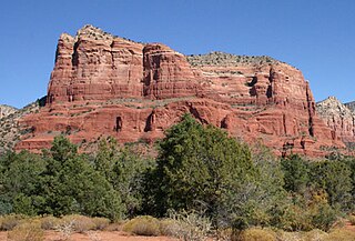
Cathedral Rock is a natural sandstone butte on the Sedona skyline and one of the most-photographed sights in Arizona, United States. The rock formation is located in the Coconino National Forest in Yavapai County, about a mile (1.6 km) west of Arizona Route 179, and about 2.5 miles (4.0 km) south of the "Y" intersection of Routes 179 and 89A in uptown Sedona. The summit elevation of Cathedral Rock is 4,967 feet (1,514 m).
House Mountain is a shield volcano located in the U.S. state of Arizona located between the Sedona Red Rock Country and the Verde Valley in the Coconino National Forest. House Mountain erupted approximately 13–15 million years ago on the edge of where the Mogollon Rim stood at that time. Thus, the basalt that was emitted preserved the sedimentary layers below it, including the Schnebly Hill Formation and the thin band of Fort Apache Limestone. The Mogollon Rim has receded at a rate of 1 foot per 600 years since and the current edge of the rim can be seen several miles away from the summit.

Isis Temple is a prominence in the Grand Canyon, Arizona, Southwestern United States. It is located below the North Rim and adjacent to Granite Gorge. The prominence lies north of the north bank of the west-flowing Colorado River and is just north of Granite Gorge. The Trinity Creek and canyon flow due south at its west border; its north, and northeast border/flank is formed by Phantom Creek and canyon, a west tributary of Bright Angel Creek; the creeks intersect about 3 mi (4.8 km) southeast, and 1.0 mi (1.6 km) north of Granite Gorge. The Isis Temple prominence, is only about 202 ft (62 m) lower than Grand Canyon Village, the main public center on Grand Canyon’s South Rim.
Munds Mountain Wilderness is an 18,150-acre wilderness area in the Coconino National Forest in the U.S. state of Arizona. It is immediately southeast of Sedona between Arizona State Route 179 and Interstate 17. The wilderness lies within the Munds Mountain and Sedona quadrangles of the national topographic map of the United States Geological Survey.

The Schnebly Hill Formation is a section of red bed deposits found at the Colorado Plateau, near Sedona, Arizona. It is a dark red sandstone, from 800 feet (240 m) to 1,000 feet (300 m) thick. It lies between Coconino Sandstone and the older Hermit Formation. It is near the Supai Group.