Cottonwood, Arizona

Last updated

Cottonwood
Commercial Historic District (Cottonwood, Arizona).jpg
"Old Town" Historic District
Flag of Cottonwood, Arizona.gif
Motto: 
"The Heart of Arizona Wine Country" "Inspiring a Vibrant Community"
Yavapai County Arizona Incorporated and Unincorporated areas Cottonwood Highlighted 0416410.svg
Location of Cottonwood in Yavapai County, Arizona
USA Arizona location map.svg
Red pog.svg
Cottonwood
Location in Arizona
Usa edcp location map.svg
Red pog.svg
Cottonwood
Cottonwood (the United States)
Coordinates: 34°43′56″N112°01′07″W / 34.73222°N 112.01861°W / 34.73222; -112.01861
Country Flag of the United States.svg  United States
State Flag of Arizona.svg  Arizona
County Flag placeholder.svg Yavapai
Named for Cottonwood Tree
Government
  TypeCouncil-Manager
  BodyCottonwood City Council (6 members plus Mayor)
  MayorTim Elinski[ citation needed ]
Area
[1]
  Total16.61 sq mi (43.03 km2)
  Land16.61 sq mi (43.03 km2)
  Water0.00 sq mi (0.00 km2)
Elevation
[2]
3,461 ft (1,055 m)
Population
 (2020)
  Total12,029
  Density724.03/sq mi (279.56/km2)
Time zone UTC-7 (MST)
  Summer (DST) UTC−7 (no DST/PDT)
ZIP code
86326
Area code 928
FIPS code 04-16410
GNIS ID(s)2410242 [2]
Website City of Cottonwood

Cottonwood is a city in Yavapai County, Arizona, United States. According to the 2010 census, the population of the city is 11,265. [3]

Contents

Geography

According to the United States Census Bureau, the city has a total area of 10.7 square miles (28 km2), all land.

Climate

Cottonwood has a semi-arid climate (Köppen Classification BSk). In January the average high temperature is 55 °F (13 °C) with a low of 26 °F (−3 °C). In July the average high temperature is 97 °F (36 °C) with a low of 68 °F (20 °C). Annual precipitation is approximately 13 inches (33 cm).

Climate data for Cottonwood, Arizona
(Tuzigoot, 1991–2020 normals, extremes 1920–present)
MonthJanFebMarAprMayJunJulAugSepOctNovDecYear
Record high °F (°C)80
(27)
87
(31)
92
(33)
98
(37)
107
(42)
118
(48)
116
(47)
114
(46)
113
(45)
102
(39)
89
(32)
79
(26)
118
(48)
Mean maximum °F (°C)71.5
(21.9)
74.9
(23.8)
82.5
(28.1)
91.3
(32.9)
99.5
(37.5)
108.1
(42.3)
109.9
(43.3)
106.7
(41.5)
100.8
(38.2)
92.5
(33.6)
81.8
(27.7)
71.3
(21.8)
111.3
(44.1)
Mean daily maximum °F (°C)60.9
(16.1)
64.5
(18.1)
71.2
(21.8)
78.9
(26.1)
87.9
(31.1)
98.9
(37.2)
101.1
(38.4)
98.4
(36.9)
93.1
(33.9)
82.6
(28.1)
70.5
(21.4)
59.8
(15.4)
80.6
(27.0)
Daily mean °F (°C)45.3
(7.4)
48.6
(9.2)
54.4
(12.4)
61.0
(16.1)
69.4
(20.8)
79.1
(26.2)
83.9
(28.8)
82.0
(27.8)
75.7
(24.3)
64.7
(18.2)
53.3
(11.8)
44.6
(7.0)
63.5
(17.5)
Mean daily minimum °F (°C)29.8
(−1.2)
32.7
(0.4)
37.6
(3.1)
43.0
(6.1)
50.8
(10.4)
59.3
(15.2)
66.8
(19.3)
65.5
(18.6)
58.4
(14.7)
46.7
(8.2)
36.0
(2.2)
29.4
(−1.4)
46.3
(7.9)
Mean minimum °F (°C)20.9
(−6.2)
23.2
(−4.9)
28.4
(−2.0)
33.6
(0.9)
40.1
(4.5)
49.6
(9.8)
59.3
(15.2)
59.1
(15.1)
49.0
(9.4)
36.0
(2.2)
25.2
(−3.8)
20.1
(−6.6)
17.8
(−7.9)
Record low °F (°C)5
(−15)
6
(−14)
14
(−10)
24
(−4)
29
(−2)
40
(4)
52
(11)
46
(8)
41
(5)
21
(−6)
8
(−13)
8
(−13)
5
(−15)
Average precipitation inches (mm)1.10
(28)
0.99
(25)
1.01
(26)
0.43
(11)
0.42
(11)
0.18
(4.6)
1.64
(42)
2.15
(55)
1.30
(33)
0.96
(24)
0.70
(18)
1.12
(28)
12.00
(305)
Average snowfall inches (cm)0.2
(0.51)
0.1
(0.25)
0.1
(0.25)
0.2
(0.51)
0.0
(0.0)
0.0
(0.0)
0.0
(0.0)
0.0
(0.0)
0.0
(0.0)
0.0
(0.0)
0.1
(0.25)
0.3
(0.76)
1.0
(2.5)
Average precipitation days (≥ 0.01 inch)4.65.24.72.72.51.37.58.44.93.63.14.452.9
Average snowy days (≥ 0.1 inch)0.20.20.10.10.00.00.00.00.00.00.00.20.8
Source: National Oceanic and Atmospheric Administration [4] [5]

Demographics

Historical population
CensusPop.Note
1950 1,626
1960 1,87915.6%
1970 2,61038.9%
1980 4,55074.3%
1990 5,91830.1%
2000 9,17955.1%
2010 11,26522.7%
2020 12,0296.8%
U.S. Decennial Census [6]

At the 2000 census there were 9,179 people, 3,983 households and 2,369 families in the city. The population density was 860.3 inhabitants per square mile (332.2/km2). There were 4,427 housing units at an average density of 414.9 per square mile (160.2/km2). The racial makeup of the city was 85.2% White, 0.5% Black or African American, 1.6% Native American, 0.4% Asian, <0.1% Pacific Islander, 9.7% from other races, and 2.6% from two or more races. 20.5% of the population were Hispanic or Latino of any race. [7] Of the 3,983 households 25.3% had children under the age of 18 living with them, 44.5% were married couples living together, 10.8% had a female as Head of Household with no Husband present, and 40.5% were non-families. 34.4% of households were one person and 19.1% were one person aged 65 or older. The average household size was 2.27 and the average family size was 2.90.

The age distribution was 23.4% under the age of 18, 8.2% from 18 to 24, 23.3% from 25 to 44, 21.4% from 45 to 64, and 23.8% 65 or older. The median age was 41 years. For every 100 females, there were 86.9 males. For every 100 females age 18 and over, there were 81.4 males.

The median household income was $27,444 and the median family income was $37,794. Males had a median income of $24,308 versus $19,977 for females. The per capita income for the city was $17,518. About 8.9% of families and 13.5% of the population were below the poverty line, including 19.5% of those under age 18 and 11.3% of those age 65 or over.

The city became one of the Arizona municipalities to approve of civil unions for same-sex partners. [8] [9]

Economy

Cottonwood is the economic heart of the Verde Valley. The City of Cottonwood recently went through an extensive re-branding process and is now known as the “Heart of Arizona Wine Country". Focused on the Old Town Cottonwood tourist area, the City is the epicenter of the renowned Verde Valley wine region of Arizona.

Education

Cottonwood-Oak Creek School District operates public schools.

Library

The Cottonwood Public Library is part of the Yavapai County Library Network and serves the city of Cottonwood along with surrounding cities including Clarkdale, Camp Verde, Jerome, Rimrock and unincorporated areas of the Verde Valley in Yavapai County. [10]

Transportation

The city is served by Cottonwood Airport, a general aviation facility.

Black Bert's Service Station Cottonwood SW01.jpg
Black Bert's Service Station

Notable people

See also

Related Research Articles

<span class="mw-page-title-main">Mohave County, Arizona</span> County in Arizona, United States

Mohave County is in the northwestern corner of the U.S. state of Arizona. As of the 2020 census, its population was 213,267. The county seat is Kingman, and the largest city is Lake Havasu City. It is the fifth largest county in the United States.

<span class="mw-page-title-main">Yavapai County, Arizona</span> County in Arizona, United States

Yavapai County is near the center of the U.S. state of Arizona. As of the 2020 census, its population was 236,209, making it the fourth-most populous county in Arizona. The county seat is Prescott.

<span class="mw-page-title-main">Sedona, Arizona</span> City in Coconino and Yavapai Counties, Arizona, US

Sedona is a city that straddles the county line between Coconino and Yavapai counties in the northern Verde Valley region of the U.S. state of Arizona. As of the 2010 census, its population was 10,031. It is within the Coconino National Forest.

<span class="mw-page-title-main">Rio Verde, Arizona</span> CDP in Maricopa County, Arizona

Rio Verde is a master-planned community just east of Scottsdale, in Arizona. It is also a census-designated place (CDP) in Maricopa County, Arizona, United States, located in the far, far northeast area of the whole Phoenix Metropolitan Area. The population was 2,210 as of the 2020 census, up from 1,811 at the 2010 census.

<span class="mw-page-title-main">Sun Lakes, Arizona</span> CDP in Maricopa County, Arizona

Sun Lakes is an unincorporated community and census-designated place (CDP) in Maricopa County, Arizona, United States. The population was 14,868 at the 2020 census. Sun Lakes is an active adult community comprising five country club communities in three homeowner associations. These include the gated communities of Oakwood and IronWood (IronOaks), the gated and non-gated communities of Palo Verde and Cottonwood, and the non-gated community of Sun Lakes 1. Sun Lakes is a master-planned community developed by Robson Communities.

<span class="mw-page-title-main">Wickenburg, Arizona</span> Town in Maricopa County, Arizona

Wickenburg is a town in Maricopa and Yavapai counties, Arizona, United States. As of the 2020 census, the population of the town was 7,474, up from 6,363 in 2010.

<span class="mw-page-title-main">Bagdad, Arizona</span> CDP in Yavapai County, Arizona

Bagdad is a copper mining community and census-designated place (CDP) in Yavapai County, Arizona, United States, in the western part of the state. It is one of only two remaining company towns in Arizona. The population was 1,876 at the 2010 census, up from 1,578 in 2000.

<span class="mw-page-title-main">Village of Oak Creek, Arizona</span> Community in Yavapai County, Arizona

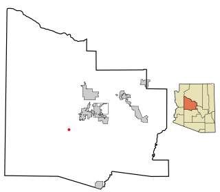
Village of Oak Creek is an unincorporated community located within Big Park a census-designated place (CDP) in Yavapai County, Arizona, United States. The population was 6,147 at the 2010 census, up from 5,245 in 2000. Big Park is the name of the CDP while the community is more commonly known as the Village of Oak Creek (VOC), and is a bedroom community for Sedona, located seven miles away. Tourism and service to retirees and second-home owners are the basis for the local economy. Big Park, the pioneers' name for the large open area that became the Village of Oak Creek in the early 1960s, is set among scenic red-rock buttes and canyons. The Bell Rock scenic area adjoins the north end of VOC, and the town is surrounded by the Coconino National Forest. A Forest Service Visitor Center is located at the south end of VOC.

<span class="mw-page-title-main">Black Canyon City, Arizona</span> CDP in Yavapai County, Arizona

Black Canyon City is an unincorporated community and census-designated place (CDP) in Yavapai County, Arizona, United States. The population is 2,677 as of the 2020 census.

<span class="mw-page-title-main">Camp Verde, Arizona</span> Town in Yavapai County, Arizona

Camp Verde is a town in Yavapai County, Arizona, United States. As of the 2010 census, the population of the town is 10,873.

<span class="mw-page-title-main">Chino Valley, Arizona</span> Town in Yavapai County, Arizona

Chino Valley is a town in Yavapai County, Arizona, United States. According to the 2021 U.S. Census, the population of the town is 13,492.

<span class="mw-page-title-main">Clarkdale, Arizona</span> Town in Yavapai County, Arizona

Clarkdale is a town in Yavapai County, Arizona, United States. The Verde River flows through the town as does Bitter Creek, an intermittent tributary of the river. According to the 2021 census, the population of the town was 4,419.

<span class="mw-page-title-main">Cordes Lakes, Arizona</span> CDP in Yavapai County, Arizona

Cordes Lakes is a census-designated place (CDP) in Yavapai County, Arizona, United States. The population was 2,058 at the 2000 census. The Agua Fria National Monument lies to the east and south of the community and Arcosanti is to the north.

<span class="mw-page-title-main">Cornville, Arizona</span> CDP in Yavapai County, Arizona

Cornville is a census-designated place (CDP) in Yavapai County, Arizona, United States. The population as of the 2010 United States Census was 3,280, down from 3,335 at the 2000 census. For statistical purposes, the United States Census Bureau has defined Cornville as a CDP that includes the unincorporated communities of Cornville and Page Springs.

<span class="mw-page-title-main">Lake Montezuma, Arizona</span> CDP in Yavapai County, Arizona

Lake Montezuma is a census-designated place (CDP) in Yavapai County in the U.S. state of Arizona. The population was 5,111 at the 2020 census. The CDP includes the communities of Rimrock and McGuireville. Located along Interstate 17, it is 20 miles (32 km) south of Sedona and 8 miles (13 km) north of Camp Verde in central Arizona's Verde Valley.

<span class="mw-page-title-main">Peeples Valley, Arizona</span> CDP in Yavapai County, Arizona

Peeples Valley is a census-designated place (CDP) in Yavapai County, Arizona, United States. The population was 374 at the 2000 census.

<span class="mw-page-title-main">Spring Valley, Arizona</span> CDP in Yavapai County, Arizona

Spring Valley is a census-designated place (CDP) in Yavapai County, Arizona, United States. The population was 1,019 at the 2000 census.

<span class="mw-page-title-main">Wilhoit, Arizona</span> Census-designated place in Yavapai County, Arizona, United States

Wilhoit is a census-designated place (CDP) in Yavapai County, Arizona, United States. The population was 664 at the 2000 census.

<span class="mw-page-title-main">Cottonwood Falls, Kansas</span> City in Chase County, Kansas

Cottonwood Falls is the largest city and county seat of Chase County, Kansas, United States. As of the 2020 census, the population of the city was 851. It is located south of Strong City along the south side of the Cottonwood River.

<span class="mw-page-title-main">Verde Village, Arizona</span> CDP in Yavapai County, Arizona

Verde Village is a census-designated place (CDP) in Yavapai County, Arizona, United States. The population was 11,605 at the 2010 census. It is a retirement and bedroom community for Cottonwood.

References

  1. "2020 U.S. Gazetteer Files". United States Census Bureau. Retrieved October 29, 2021.
  2. 1 2 2410242
  3. "U.S. Census website". United States Census Bureau . Retrieved August 5, 2014.
  4. "NOWData – NOAA Online Weather Data". National Oceanic and Atmospheric Administration . Retrieved August 14, 2022.
  5. "U.S. Climate Normals Quick Access – Station: Tuzigoot, AZ". National Oceanic and Atmospheric Administration. Retrieved January 28, 2023.
  6. "Census of Population and Housing". Census.gov. Retrieved June 4, 2016.
  7. "U.S. Census website". United States Census Bureau . Retrieved January 31, 2008.
  8. "Cottonwood Council approves civil union registry". Verde Independent. Retrieved July 27, 2018.
  9. "Cottonwood latest to approve civil unions". KNXV. Associated Press. December 19, 2013. Archived from the original on November 16, 2018. Retrieved July 27, 2018.
  10. "Cottonwood Public Library". Cottonwood Public Library. Retrieved February 12, 2013.
  11. "BRIGADIER GENERAL FRED P. LEWIS". af.mil. Defense Media Activity. Retrieved June 29, 2023.