Related Research Articles

Maricopa County is in the south-central part of the U.S. state of Arizona. As of the 2020 census the population was 4,420,568, or about 62% of the state's total, making it the fourth-most populous county in the United States and the most populous county in Arizona, and making Arizona one of the nation's most centralized states. The county seat is Phoenix, the state capital and fifth-most populous city in the United States.

Black Canyon City is an unincorporated community and census-designated place (CDP) in Yavapai County, Arizona, United States. The population is 2,677 as of the 2020 census.

Camp Verde is a town in Yavapai County, Arizona, United States. As of the 2010 census, the population of the town is 10,873.

Chino Valley is a town in Yavapai County, Arizona, United States. According to the 2020 United States census, the population of the town is 13,020.

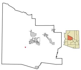
Congress is a census-designated place (CDP) in Yavapai County, Arizona, United States. Once a gold-mining center for the Congress Mine and then a ghost town, Congress now serves as a retirement and bedroom community for nearby Wickenburg. The population was 1,811 at the 2020 census.

Cordes Lakes is a census-designated place (CDP) in Yavapai County, Arizona, United States. The population was 2,058 at the 2000 census. The Agua Fria National Monument lies to the east and south of the community and Arcosanti is to the north.

Cornville is a census-designated place (CDP) in Yavapai County, Arizona, United States. The population as of the 2010 United States Census was 3,280, down from 3,335 at the 2000 census. For statistical purposes, the United States Census Bureau has defined Cornville as a CDP that includes the unincorporated communities of Cornville and Page Springs.

Mayer is a census-designated place (CDP) in Yavapai County, Arizona, United States. The population was 1,408 at the 2000 census. Mayer includes three sites listed on the National Register of Historic Places: the Mayer Apartments, the Mayer Business Block, and the Mayer Red Brick Schoolhouse.

Peeples Valley is a census-designated place (CDP) in Yavapai County, Arizona, United States. The population was 374 at the 2000 census.

Prescott is a city and the county seat of Yavapai County, Arizona, United States. As of 2020 Census, the city's population was 45,827.
Wilhoit is a census-designated place (CDP) in Yavapai County, Arizona, United States. The population was 664 at the 2000 census.

Yarnell is a census-designated place (CDP) in Yavapai County, Arizona, United States. The population of Yarnell was 649 at the 2010 census. Yarnell's economy is based on ranching, mining and services to travelers and retirees. Peeples Valley, three miles north, is closely linked to Yarnell.

The Yavapai-Prescott Indian Tribe, formerly known as the Yavapai-Prescott Tribe of the Yavapai Reservation, a federally recognized tribe of Yavapai people. Fewer than 200 people are enrolled in the tribe.
Arizona's 1st congressional district is a congressional district located in the U.S. state of Arizona, covering northeastern Maricopa County. Before 2023, geographically, it was the eleventh-largest congressional district in the country and included much of the state outside the Phoenix and Tucson metropolitan areas. From 2013 through 2022, it also included the Navajo Nation, the Hopi reservation, and the Gila River Indian Community, with 25% of the population being Native American. At that time, the district had more Native Americans than any other congressional district in the United States. In the 2022 elections, David Schweikert was elected in the redefined district. It was one of 18 districts that would have voted for Joe Biden in the 2020 presidential election had they existed in their current configuration while being won or held by a Republican in 2022.
Skull Valley School District is a school district in Yavapai County, Arizona. It operates a single public K-8 school, Skull Valley Elementary School, in Skull Valley. The school has four teachers and generally 20–30 students. Enrollment in 2017 was 14 students.

Weaver, or Weaverville, is a former gold mining town, now a deserted ghost town, in Yavapai County, Arizona, United States. All that remains are some rusting mining machinery, a partially restored cemetery, and the ruins of a stone house.
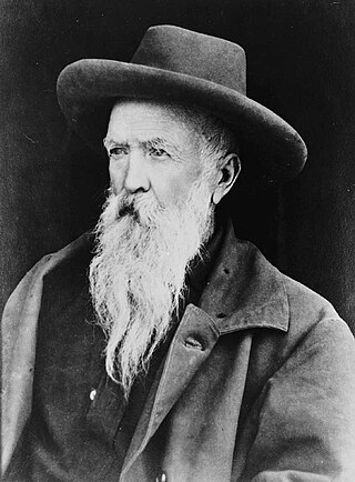
Robert W. Groom was an American surveyor and politician served as a member of the California State Assembly, representing California's 1st State Assembly district from 1858 to 1859 and 1860 to 1861. He was previously a miner, and used his surveying skills to help lay down the communities of Prescott and Wickenburg. The community of Groom Creek, Arizona, is named after him.
Wickenburg Mountains is a mountain range located in Maricopa and Yavapai Counties in Arizona. Denver Hill, at an altitude of 4,406 feet or 1,343 meters, is the tallest peak in the range. 34°02′02″N112°33′59″W

Ponderosa Park is a populated place in Yavapai County, Arizona, United States. It is located about five miles (8.0 km) south of Prescott, Arizona off of Arizona State Route 89 via Ponderosa Road and is within the Prescott National Forest. The area was homesteaded in 1884 and contains about 300 homes. The homes vary in design from small seasonal cabins to large year-round homes. The name is derived from the prominent ponderosa pines in the National Forest.

Aztec Pass is a gap and a valley between the Juniper Mountains and Santa Maria Mountains in Yavapai County, Arizona, United States. The summit of the pass is at an elevation of 6,232 feet, at 34°56′12″N112°58′12″W the divide between Muddy Wash on the west and Walnut Creek on the east. The eastern entrance to the pass is at the mouth of the valley of Walnut Creek where it emerges from the hills on the west side of Chino Valley at 34°58′54″N112°38′04″W at an elevation of 4,583 feet / 1,397 meters. The western entrance to the pass is at the top of the valley of Muddy Wash at the foot of the Juniper Mountains, located at 34°58′30″N113°02′03″W.
References
- ↑ U.S. Geological Survey Geographic Names Information System: Groom Creek, Arizona
- ↑ "Yavapai County". Jim Forte Postal History. Retrieved November 2, 2015.
- ↑ "Hall of fame". The Daily Courier. July 29, 2001. p. 9A. Retrieved November 2, 2015.
Municipalities and communities of Yavapai County, Arizona, United States | ||
|---|---|---|
| Cities |  | |
| Towns | ||
| CDPs | ||
| Populated places |
| |
| Indian reservations | ||
| Ghost towns | ||
| Footnotes | ‡This populated place also has portions in an adjacent county or counties | |