Chino Valley, Arizona

Last updated

Chino Valley, Arizona
Welcome to Chino Valley, Arizona (15605311066).jpg
Chino Valley welcome sign
Flag of Chino Valley, Arizona.gif
Yavapai County Arizona Incorporated and Unincorporated areas Chino Valley Highlighted 0412840.svg
Location of Chino Valley in Yavapai County, Arizona
USA Arizona location map.svg
Red pog.svg
Chino Valley, Arizona
Location in Arizona
Usa edcp location map.svg
Red pog.svg
Chino Valley, Arizona
Chino Valley, Arizona (the United States)
Coordinates: 34°45′27″N112°27′14″W / 34.75750°N 112.45389°W / 34.75750; -112.45389
CountryUnited States
State Arizona
County Yavapai
Government
  MayorJack W. Miller
Area
[1]
  Total62.48 sq mi (161.83 km2)
  Land62.46 sq mi (161.77 km2)
  Water0.02 sq mi (0.06 km2)
Elevation
4,707 ft (1,435 m)
Population
 (2020)
  Total13,020
  Density208.45/sq mi (80.48/km2)
Time zone UTC-7 (MST)
ZIP code
86323
Area code 928
FIPS code 04-12840
GNIS feature ID 27601
Website Town of Chino Valley

Chino Valley is a town in Yavapai County, Arizona, United States. According to the 2020 United States census, the population of the town is 13,020.

Contents

Geography

Chino Valley is located at 34°45′27″N112°27′14″W / 34.75750°N 112.45389°W / 34.75750; -112.45389 (34.758381, -112.449758). The town is located adjacent the southeast terminus of Chino Valley, approximately 9 miles (14 km) north at Paulden. The smaller north-trending Little Chino Valley lies just east of the townsite.

According to the United States Census Bureau, the town has a total area of 63.4 square miles (164 km2), all land.

History

Chino Valley is the site of the first Territorial Capital of Arizona. The capital moved to Prescott, 15 miles (24 km) away, in 1864. U.S. Army Cavalry Lt. Amiel W. Whipple, while traveling through the area in 1854, gave the community its name. "Chino" is the Spanish name for the abundant curly grama grass growing in the area.

In 1895, a narrow gauge branch of the United Verde and Pacific Railroad to Jerome, joining the Santa Fe, Prescott, and Phoenix Railway, was completed, and Jerome Junction was established. In 1923, the activities of Jerome Junction were absorbed by Chino Valley. [2]

In 1960, Chino Valley's population was estimated as 50 residents. [3]

The town of Chino Valley was incorporated in 1970.

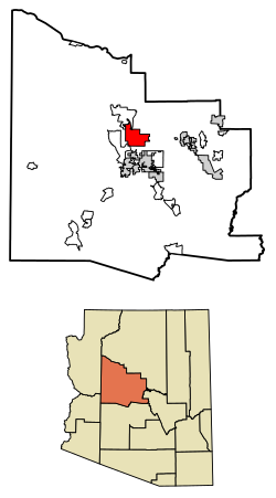
The town is in north-central Arizona, on state Highway 89, 15 miles (24 km) north of Prescott and 35 miles (56 km) south of Ash Fork, which is on Interstate 40. Chino Valley is at an elevation of about 4,750 feet (1,450 m).

Demographics

Historical population
CensusPop.Note
1970 803
1980 2,858255.9%
1990 4,83769.2%
2000 7,83562.0%
2010 10,81738.1%
2020 13,02020.4%
U.S. Decennial Census [4]

As of the census of 2000, there were 7,835 people, 3,030 households, and 2,172 families residing in the town. The population density was 421.6 inhabitants per square mile (162.8/km2). There were 3,256 housing units at an average density of 175.2 per square mile (67.6/km2). The racial makeup of the town was 94.1% White, 0.2% Black or African American, 0.9% Native American, 0.2% Asian, 0.1% Pacific Islander, 2.6% from other races, and 1.9% from two or more races. 9.8% of the population were Hispanic or Latino of any race.

There were 3,030 households, out of which 32.5% had children under the age of 18 living with them, 57.3% were married couples living together, 10.3% had a female householder with no husband present, and 28.3% were non-families. 23.0% of all households were made up of individuals, and 11.1% had someone living alone who was 65 years of age or older. The average household size was 2.58 and the average family size was 3.01.

In the town, the population was spread out, with 26.5% under the age of 18, 7.1% from 18 to 24, 25.0% from 25 to 44, 25.1% from 45 to 64, and 16.2% who were 65 years of age or older. The median age was 40 years. For every 100 females, there were 96.4 males. For every 100 females age 18 and over, there were 91.5 males.

The median income for a household in the town was $32,289, and the median income for a family was $35,013. Males had a median income of $27,160 versus $21,667 for females. The per capita income for the town was $15,555. About 12.6% of families and 15.5% of the population were below the poverty line, including 20.2% of those under age 18 and 13.5% of those age 65 or over.

Climate

Climate data for Chino Valley, Arizona
MonthJanFebMarAprMayJunJulAugSepOctNovDecYear
Mean daily maximum °F (°C)52.3
(11.3)
56.3
(13.5)
62.1
(16.7)
69.9
(21.1)
78.5
(25.8)
88.6
(31.4)
92.4
(33.6)
89.5
(31.9)
85.5
(29.7)
75.0
(23.9)
63.2
(17.3)
53.7
(12.1)
72.3
(22.4)
Mean daily minimum °F (°C)21.5
(−5.8)
24.1
(−4.4)
28.3
(−2.1)
34.4
(1.3)
41.7
(5.4)
49.8
(9.9)
59.0
(15.0)
57.2
(14.0)
49.1
(9.5)
38.0
(3.3)
27.3
(−2.6)
21.3
(−5.9)
37.6
(3.1)
Average precipitation inches (mm)0.95
(24)
0.93
(24)
0.92
(23)
0.56
(14)
0.34
(8.6)
0.28
(7.1)
1.81
(46)
2.01
(51)
1.27
(32)
0.81
(21)
0.64
(16)
0.97
(25)
11.50
(292)
Average snowfall inches (cm)2.2
(5.6)
1.4
(3.6)
1.3
(3.3)
0.2
(0.51)
0.0
(0.0)
0.0
(0.0)
0.0
(0.0)
0.0
(0.0)
0.0
(0.0)
0.0
(0.0)
0.5
(1.3)
1.5
(3.8)
7.1
(18)
Source: WRCC [5]

Education

The Chino Valley Unified School District presently operates four school facilities in the Town of Chino Valley. Territorial Early Education Center (Pre-K through Second Grade) and Del Rio Elementary (Third through Fifth Grades) students.

Heritage Middle School educates sixth through eighth graders in the district. Two County Teachers of the Year and Two Channel 3 Silver Apple Teacher award winners are on the HMS faculty.

Chino Valley High School partners with Yavapai College Campus for Agribusiness, Science & Technology, located in Chino Valley, where seniors may jointly enroll in CVHS and Yavapai for advanced study. The school's Aquaculture & Biotech Lab, Greenhouse and Livestock Facilities support the FFA program. CVHS houses five computer lab environments for students plus programs in music and art, and an FBLA program, along with the full component of extracurricular activities and sports programs.

The district operates under the supervision of a five-member governing board and one district superintendent. The district presently employs 7 administrators and 6 directors on a full-time basis, 158 certified teachers and 190 full- and part-time classified employees.

Chino Valley has two charter schools that operate in the town. Mingus Springs is a kindergarten–8th grade school that services over 180 students. Excel Education Centers is a 6th–12th grade school that services over 50 students.

Chino Valley also has a campus of Yavapai College.

Government

TitleName
MayorJack Miller
Vice MayorAnnie Perkins
Council MemberTom Armstrong
Council MemberLon Turner
Council MemberCloyce Kelly
Council MemberJohn McCafferty

Del Rio Springs

A private cemetery in Del Rio Springs holds early settlers. [6] There is a historical marker in Chino Valley which has the following inscription: [7]

Del Rio Springs
Site of original Camp Whipple established December 1863
From January 22 to May 18, 1864 the offices of the Territorial Government of Arizona were operated from tents and log cabins here, before being moved to Prescott the first permanent capital.

Del Rio Springs historic marker Chino Valley-Del Rio Spring Marker.jpg
Del Rio Springs historic marker

Related Research Articles

<span class="mw-page-title-main">Mohave County, Arizona</span> County in Arizona, United States

Mohave County is in the northwestern corner of the U.S. state of Arizona. As of the 2020 census, its population was 213,267. The county seat is Kingman, and the largest city is Lake Havasu City. It is the fifth largest county in the United States.

<span class="mw-page-title-main">Yavapai County, Arizona</span> County in Arizona, United States

Yavapai County is near the center of the U.S. state of Arizona. As of the 2020 census, its population was 236,209, making it the fourth-most populous county in Arizona. The county seat is Prescott.

<span class="mw-page-title-main">Springerville, Arizona</span> Town in Apache County, Arizona, United States

Springerville is a town in Apache County, Arizona, United States, within the White Mountains. Its postal ZIP Code is 85938. As of the 2010 census, the population of the town was 1,961.

<span class="mw-page-title-main">Wickenburg, Arizona</span> Town in Maricopa County, Arizona

Wickenburg is a town in Maricopa and Yavapai counties, Arizona, United States. The population was 7,474 at the 2020 census, and was estimated to be 7,920 in 2022.

<span class="mw-page-title-main">Bagdad, Arizona</span> CDP in Yavapai County, Arizona

Bagdad is a copper mining community and census-designated place (CDP) in Yavapai County, Arizona, United States, in the western part of the state. It is one of only two remaining company towns in Arizona. The population was 1,876 at the 2010 census, up from 1,578 in 2000.

<span class="mw-page-title-main">Black Canyon City, Arizona</span> CDP in Yavapai County, Arizona, US

Black Canyon City is an unincorporated community and census-designated place (CDP) in Yavapai County, Arizona, United States. The population is 2,677 as of the 2020 census.

<span class="mw-page-title-main">Camp Verde, Arizona</span> Town in Yavapai County, Arizona

Camp Verde is a town in Yavapai County, Arizona, United States. As of the 2010 census, the population of the town is 10,873.

<span class="mw-page-title-main">Clarkdale, Arizona</span> Town in Yavapai County, Arizona

Clarkdale is a town in Yavapai County, Arizona, United States. The Verde River flows through the town as does Bitter Creek, an intermittent tributary of the river. According to the 2021 census, the population of the town was 4,419.

<span class="mw-page-title-main">Congress, Arizona</span> CDP in Yavapai County, Arizona

Congress is a census-designated place (CDP) in Yavapai County, Arizona, United States. Once a gold-mining center for the Congress Mine and then a ghost town, Congress now serves as a retirement and bedroom community for nearby Wickenburg. The population was 1,811 at the 2020 census.

<span class="mw-page-title-main">Cordes Lakes, Arizona</span> CDP in Yavapai County, Arizona

Cordes Lakes is a census-designated place (CDP) in Yavapai County, Arizona, United States. The population was 2,058 at the 2000 census. The Agua Fria National Monument lies to the east and south of the community and Arcosanti is to the north.

<span class="mw-page-title-main">Dewey–Humboldt, Arizona</span> Town in Yavapai County, Arizona

Dewey–Humboldt is a town in Yavapai County, Arizona, United States. The population of the town was 3,894 according to the 2010 census. The Dewey–Humboldt area was a census-designated place (CDP) at the 2000 census, at which time its population was 6,295.

<span class="mw-page-title-main">Mayer, Arizona</span> CDP in Yavapai County, Arizona

Mayer is a census-designated place (CDP) in Yavapai County, Arizona, United States. The population was 1,408 at the 2000 census. Mayer includes three sites listed on the National Register of Historic Places: the Mayer Apartments, the Mayer Business Block, and the Mayer Red Brick Schoolhouse.

<span class="mw-page-title-main">Peeples Valley, Arizona</span> CDP in Yavapai County, Arizona

Peeples Valley is a census-designated place (CDP) in Yavapai County, Arizona, United States. The population was 374 at the 2000 census.

<span class="mw-page-title-main">Prescott, Arizona</span> City in Arizona, United States

Prescott is a city and the county seat of Yavapai County, Arizona, United States. As of 2020 Census, the city's population was 45,827.

<span class="mw-page-title-main">Prescott Valley, Arizona</span> Town in Yavapai County, Arizona

Prescott Valley is a town located in Yavapai County, Arizona, United States, approximately 8 miles (13 km) east of Prescott. According to the 2020 United States Census, Prescott Valley has a population of 46,785 residents.

<span class="mw-page-title-main">Seligman, Arizona</span> CDP in Yavapai County, Arizona

Seligman is a census-designated place (CDP) on the northern border of Yavapai County, in northwestern Arizona, United States. The population was 456 at the 2020 census. It is one of the stops on historic U.S. Route 66.

<span class="mw-page-title-main">Spring Valley, Arizona</span> CDP in Yavapai County, Arizona

Spring Valley is a census-designated place (CDP) in Yavapai County, Arizona, United States. The population was 1,019 at the 2000 census.

<span class="mw-page-title-main">Wilhoit, Arizona</span> Census-designated place in Yavapai County, Arizona, United States

Wilhoit is a census-designated place (CDP) in Yavapai County, Arizona, United States. The population was 664 at the 2000 census.

<span class="mw-page-title-main">Williamson, Arizona</span> CDP in Yavapai County, Arizona

Williamson is a census-designated place (CDP) in Yavapai County, Arizona, United States. The population was 3,776 at the 2000 census and 6,196 at the 2020 census. The name "Wiliamson" is a misnomer, perhaps propagated by federal bureaucratic error; the area has long been known as "Williamson Valley" after the major road through the area, Williamson Valley Road.

<span class="mw-page-title-main">Yarnell, Arizona</span> CDP in Yavapai County, Arizona

Yarnell is a census-designated place (CDP) in Yavapai County, Arizona, United States. The population of Yarnell was 649 at the 2010 census. Yarnell's economy is based on ranching, mining and services to travelers and retirees. Peeples Valley, three miles north, is closely linked to Yarnell.

References

  1. "2020 U.S. Gazetteer Files". United States Census Bureau. Retrieved October 29, 2021.
  2. Massey, Peter; Wilson, Jeanne (2006). Backcountry Adventures Arizona: The Ultimate Guide to the Arizona Backcountry for Anyone With a Sport Utility Vehicle. Adler Publishing Co. pp. 65, 261. ISBN   1-930193-28-9 . Retrieved July 31, 2010.
  3. "Arizona". World Book Encyclopedia. Vol. A. Chicago: Field Enterprises Educational Corporation. 1960. p. 557.
  4. "Census of Population and Housing". Census.gov. Retrieved June 4, 2016.
  5. "CHINO VALLEY, ARIZONA (021654)". Western Regional Climate Center. Retrieved December 16, 2022.
  6. Enos, Cindy; Helten, Bonnie (June 11, 2009). "Del Rio Springs Cemetery". American Pioneer & Cemetery Research Project. Neal Du Shane.
  7. "Del Rio Springs - Chino Valley - AZ - US".