Related Research Articles

Sierra Grande is an extinct stratovolcano in northeastern New Mexico that rises 2,200 feet above the surrounding plain. It is part of the inactive Raton-Clayton volcanic field.
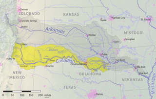
The Beaver River is an intermittent river, 280 miles (450 km) long, in western Oklahoma and northern Texas in the United States. It is a tributary of the North Canadian River, draining an area of 11,690 square miles (30,300 km2) in a watershed that extends to northeastern New Mexico and includes most of the Oklahoma Panhandle.
Beaver Creek is a tributary of the Des Moines River that rises at the northern border of Boone County in the U.S. state of Iowa, and then flows generally south and southeast through western Boone County, northeastern Dallas County, and finally northwestern Polk County before flowing into the Des Moines River approximately a mile south of the Saylorville Reservoir in Polk County. In total, the main channel is approximately 77 miles (124 km) in length, and the watershed drains approximately 380 square miles (980 km2).

The Rabbit Ears are a pair of mountain peaks in northeastern New Mexico, United States, 8 kilometres (5.0 mi) north of the city of Clayton. The two peaks were a distinctive landmark along the Cimarron Cutoff of the Santa Fe Trail, a major route for westbound settlers in the 19th century. The formation was designated a National Historic Landmark in 1963.The name is that of a Native American chief who was killed here in a battle with the Spanish in 1717.
U.S. Route 412 is a U.S. highway in the south-central portion of the United States, connecting Springer, New Mexico to Columbia, Tennessee. A 504.11-mile (811.29 km) section of the highway crosses the state of Oklahoma, traversing the state from west to east. Entering the state southwest of Boise City, US-412 runs the length of the Oklahoma Panhandle and serves the northern portion of the state's main body, before leaving the state at West Siloam Springs. Along the way, the route serves many notable cities and towns, including Boise City, Guymon, Woodward, Enid, and the state's second-largest city, Tulsa.
Carrizo Creek is a 145-mile-long (233 km) river in New Mexico and Texas. It is a tributary of Rita Blanca Creek, itself a tributary of the Canadian River. Via the Arkansas and Mississippi rivers, water from Carrizo Creek eventually reaches the Gulf of Mexico. It is sometimes also known as the Carrizo River.
Coldwater Creek is an intermittently-flowing stream in northeastern New Mexico, and the panhandles of Oklahoma and Texas. As far back as 1907, the USGS reported that Coldwater Creek is a dry sand bed most of the year. One source says that Coldwater Creek is also known as Rabbit Ears Creek, because it rises near Rabbit Ears, a pair of mountain peaks in Union County, New Mexico. According to the United States Geological Survey (USGS), Coldwater Creek drains an area of 1,903 square miles (4,930 km2).
Kiowa Creek is a watercourse in Texas and Oklahoma that becomes a tributary of the Beaver River. It originates southwest of Huntoon and east of Perryton in northeastern Ochiltree County, Texas. It travels generally east until southwest of Darrouzett in Lipscomb County, then turns northeast and passes just south and east of that town. It continues generally northeasterly into Beaver County, Oklahoma, where it is joined by Camp Creek. The stream enters Harper County west of Laverne, Oklahoma, and continues to its joinder with the Beaver River north-northwest of Laverne.

The environment of Iowa has been heavily affected by agricultural production since it became a U.S. state in 1846. However, there remain natural areas in Iowa that reflect a wide varieties of environmental niches.
South Carrizo Creek forms either just west of the Oklahoma line in New Mexico, or east inside Oklahoma to the northwest of Wheeless, Oklahoma. It is intermittent. It travels generally northeast through Black Mesa State Park where it is impounded to form Lake Carl Etling, before being joined by Willow Creek and continuing northeast to flow into the Cimarron River.
North Carrizo Creek forms in Baca County, Colorado at the confluence of East Carrizo Creek and West Carrizo Creek, at a point about 6 miles north of the Preston Monument, the tripoint of Colorado, Oklahoma and New Mexico. North Carrizo Creek then flows generally south-southeast into Oklahoma to join the Cimarron River northeast of Kenton, Oklahoma.
East Carrizo Creek rises in Las Animas County, Colorado north of Mt. Carrizo and east of Kim, Colorado, and flows generally southeast before turning south. It joins with West Carrizo Creek at a point about 6 miles north of the Preston Monument to form North Carrizo Creek. North Carrizo Creek then flows generally south-southeast into Oklahoma to join the Cimarron River northeast of Kenton, Oklahoma.
Carrizo Creek forms in Arizona north of Cibecue, before flowing generally southeast, being joined by Corduroy Creek around the town of Carrizo, and continuing generally south to join the Salt River.
Carrizozo Creek is a watercourse in the northeast corner of New Mexico, with a small portion extending into the northwestern Oklahoma Panhandle. The creek originates northwest of Clayton Lake State Park and northeast of Grenville, New Mexico about halfway to the Colorado border, being just north of Corrumpa Creek and just west of New Mexico State Road 370. It meanders generally east-northeast into Oklahoma, loops northwest heading back into New Mexico, and then turns generally east flowing into Oklahoma again. Where Carrizozo Creek and the Dry Cimarron River come together in Cimarron County, Oklahoma west of Kenton, the Cimarron River is formed.
Seneca Creek, also known as Cienequilla Creek, is a watercourse in New Mexico and Oklahoma. Running south of, and roughly parallel to, Corrumpa Creek, it originates south-southeast of Des Moines, New Mexico and east-northeast of Grenville, and travels generally east, eventually crossing into Oklahoma. Where it finally joins Corrumpa Creek about 4.5 miles northwest of Felt, Oklahoma, the combined stream becomes the Beaver River.
Spring Creek is a tributary of the Beaver River in Harper County, Oklahoma, south of Laverne. It is formed by the joinder of two other streams, known as the North Fork Spring Creek and the South Fork Spring Creek. Both the North Fork and the South Fork originate southwest of Laverne, just inside Beaver County. The North Fork heads northeasterly over the western Harper County line, whereas the South Fork heads east over the western border of Ellis County before taking a more north-northwesterly direction and crossing over the southern border of Harper County. The forks meet south-southwest of Laverne and just north of US-412/US-270. Spring Creek then travels generally northeast. Maps typically show the creek terminating southeast of Laverne short of reaching the Beaver, but the watershed extends all the way to the river.
Kiowa Creek is a stream in Comanche County, Kansas. Its watershed includes multiple other streams. West Kiowa Creek forms in northeast Clark County, Kansas and flows generally southeast, passing through the southwestern corner of Kiowa County, Kansas where it is joined by Turkey Creek and Little Turkey Creek. It continues into Comanche County, where it is joined by Middle Kiowa Creek, a southerly-flowing stream originating in Kiowa County to the north. The combined stream flows generally south, and becomes simply Kiowa Creek at some point. It is later joined by East Kiowa Creek, also a southerly-flowing stream originating in Kiowa County to the north, and one having its own tributary, Wiggins Creek. Kiowa Creek continues generally south, and travels along the eastern border of the town of Protection, Kansas, before becoming a tributary of Cavalry Creek to the southeast of Protection. Cavalry Creeks feeds into Bluff Creek, which eventually becomes a tributary of the Cimarron River before that watercourse enters Oklahoma.
Lake Evans Chambers, also known as Evans Chambers Lake, is a fishing lake constructed by the Oklahoma Department of Wildlife Conservation in 1965 in Beaver County, Oklahoma, 18 miles west of Laverne. The lake has 80 acres of surface area, and 2.8 miles of shoreline. The lake has a boat ramp, and anglers may find Largemouth Bass, White Bass, White Crappie, Black Crappie, Bluegill Sunfish, Channel Catfish, and Walleye.
Lake Frederick is a reservoir in Tillman County, Oklahoma. It is located about 15 miles northeast of the town of Frederick, which owns it. It was constructed in 1974 for flood control and to provide a water supply. It has a total surface area of 878 acres, and a total volume of 9,663 acre-feet. It has about 18 miles of shoreline.
References
- ↑ "Corrumpa Creek". Geographic Names Information System . United States Geological Survey . Retrieved August 28, 2021.
- 1 2 3 "Corrumpa Creek". Natural Atlas. Retrieved August 18, 2021.
- ↑ "Weatherly Lake in Union County NM". HomeTownLocator.com. Retrieved August 18, 2021.
- ↑ "South Branch Corrumpa Creek". Natural Atlas. Retrieved August 18, 2021.
- ↑ "North Branch Corrumpa Creek". Natural Atlas. Retrieved August 18, 2021.
- ↑ "Corrumpa Creek, Boise City, Oklahoma, United States". Bing Maps. Retrieved August 18, 2021.
- ↑ "Feature Detail Report for: Beaver River". USGS. Retrieved August 18, 2021.
- ↑ "Beaver-Canadian-River". Where Eagles Fly. Retrieved August 18, 2021.
- 1 2 "McNees Crossing". National Park Service. Retrieved June 18, 2021.
- ↑ "Rabbit Ears Mountain". National Park Service. Retrieved June 18, 2021.